Skip header and navigation

20 records – page 1 of 1.

The battle continues over the annexation of county island 80-2. Some residents favor annexation by Arcadia, while others wish to become a part of Temple City. The Arcadia City Council has approved annexation of the Shelter Isle Village condominium as a separate unit. Costs involved in the annexation of the rest of the area are discussed.

https://arcadiahistory.andornot.com/en/permalink/newspaper414
Newspaper
Arcadia Tribune
Date
July 22, 1982
Pages
p. A-1
Newspaper
Arcadia Tribune
Date
July 22, 1982
Pages
p. A-1
Subjects
Annexation (Municipal Government)
Item ID
414AN
Collection
Newspaper Index
Less detail

Temple City will not try to annex an unincorporated area near Arcadia, bounded by Daines Drive on the north, Tyler Avenue on the east, West Hondo Parkway on the south and Santa Anita Avenue on the west. Temple City will continue efforts to expand the city's north and south boundaries but wanted to avoid a fight with Arcadia for this area.

https://arcadiahistory.andornot.com/en/permalink/newspaper30103
Newspaper
Pasadena Star News
Date
June 22, 2006
Pages
p. A3
Newspaper
Pasadena Star News
Date
June 22, 2006
Pages
p. A3
Subjects
Annexation
Temple City
Unincorporated areas - Los Angeles County
Item ID
30290AN
Collection
Newspaper Index
Less detail

Proposed annexation of the area between Standish Street on the north and Jeffries on the south. One hundred percent of the residents of the area have asked to be annexed, so proceedings should move rapidly.

https://arcadiahistory.andornot.com/en/permalink/newspaper399
Newspaper
Arcadia Tribune
Date
June 8, 1975
Pages
p. 1
Newspaper
Arcadia Tribune
Date
June 8, 1975
Pages
p. 1
Subjects
Annexation (Municipal Government)
Item ID
399AN
Collection
Newspaper Index
Less detail

Residents of the 80-2 Homeowners Association are regrouping in their efforts to have their 84+ acre area south and west of the city annexed. Issues involved are discussed.

https://arcadiahistory.andornot.com/en/permalink/newspaper411
Newspaper
Arcadia Tribune
Date
January 17, 1982
Pages
p. A-1
Newspaper
Arcadia Tribune
Date
January 17, 1982
Pages
p. A-1
Subjects
Annexation (Municipal Government)
Item ID
411AN
Collection
Newspaper Index
Less detail

Annexation 80-2 proponents have taken first formal step toward annexation to Arcadia. Notice states boundaries of proposed annexation.

https://arcadiahistory.andornot.com/en/permalink/newspaper417
Newspaper
Arcadia Tribune
Date
August 22, 1982
Pages
p. 1
Newspaper
Arcadia Tribune
Date
August 22, 1982
Pages
p. 1
Subjects
Annexation (Municipal Government)
Item ID
417AN
Collection
Newspaper Index
Less detail

City Council accepted an updated staff report on annexation 80-2, an 84-acre area southwest of the city.

https://arcadiahistory.andornot.com/en/permalink/newspaper416
Newspaper
Arcadia Tribune
Date
August 5, 1982
Pages
p. 1
Newspaper
Arcadia Tribune
Date
August 5, 1982
Pages
p. 1
Subjects
Annexation (Municipal Government)
Item ID
416AN
Collection
Newspaper Index
Less detail

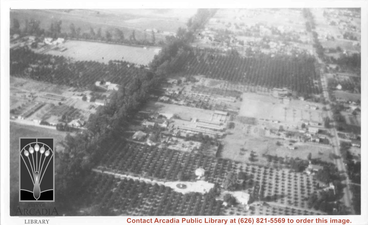
Aerial view north. Main tree-lined street is Santa Anita Avenue. Most of the orange grove in center of photo was owned by Jaspar Teague family. They had built a circular art gallery on their property at 1380 South Santa Anita Avenue. The large buildings north of Teague's and to the west of Santa Anita Avenue are chicken houses. Duarte Road is the east/west street across photo near top of photo.

https://arcadiahistory.andornot.com/en/permalink/photographs645
Date
November 1929

  1 image

Date
November 1929
Subjects
Aerial Photo Collection
Aerial views
Agriculture
Duarte Road
Orange groves
Poultry
Santa Anita Avenue
Teague, Jaspar
Physical Description
6x10 b&w
ID
641
Collection
Photographs
Images
Less detail

Plans for a series of office buildings and a high-rise hotel in the Arcadia redevelopment area require general plan and zone changes. The first move is an environmental impact report for the area bounded by the 210 Freeway on the north, the railroad tracks on the south, Fifth Avenue on the east and Second Avenue on the west.

https://arcadiahistory.andornot.com/en/permalink/newspaper1274
Newspaper
Arcadia Tribune
Date
July 13, 1980
Pages
p. A-1
Newspaper
Arcadia Tribune
Date
July 13, 1980
Pages
p. A-1
Subjects
Community Redevelopment
Item ID
1273AN
Collection
Newspaper Index
Less detail

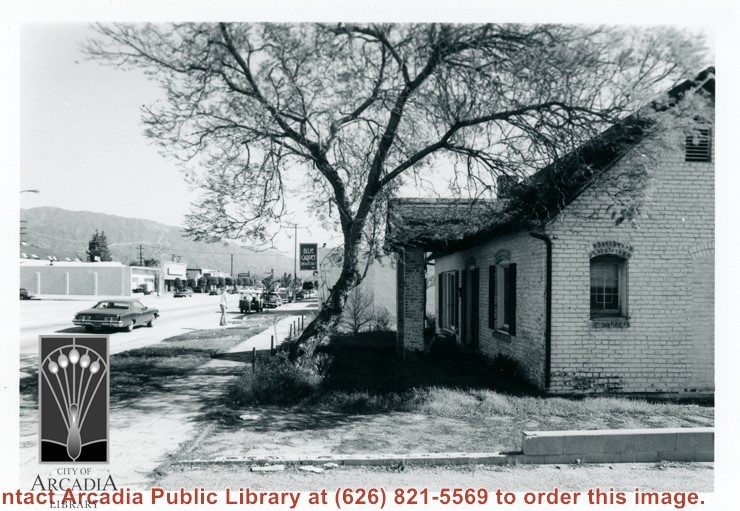
View of west end and front of house at 22 E. Foothill Blvd. House was apparently used as a residence and later, for a business. Foothill Blvd is clearly in view toward east.

https://arcadiahistory.andornot.com/en/permalink/photographs264
Date
Feb. 1978

  1 image

Date
Feb. 1978
Subjects
Houses
Business & industry
Foothill Blvd
Physical Description
3 1/2 x 5 b&w
ID
262
Collection
Photographs
Images
Less detail

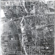
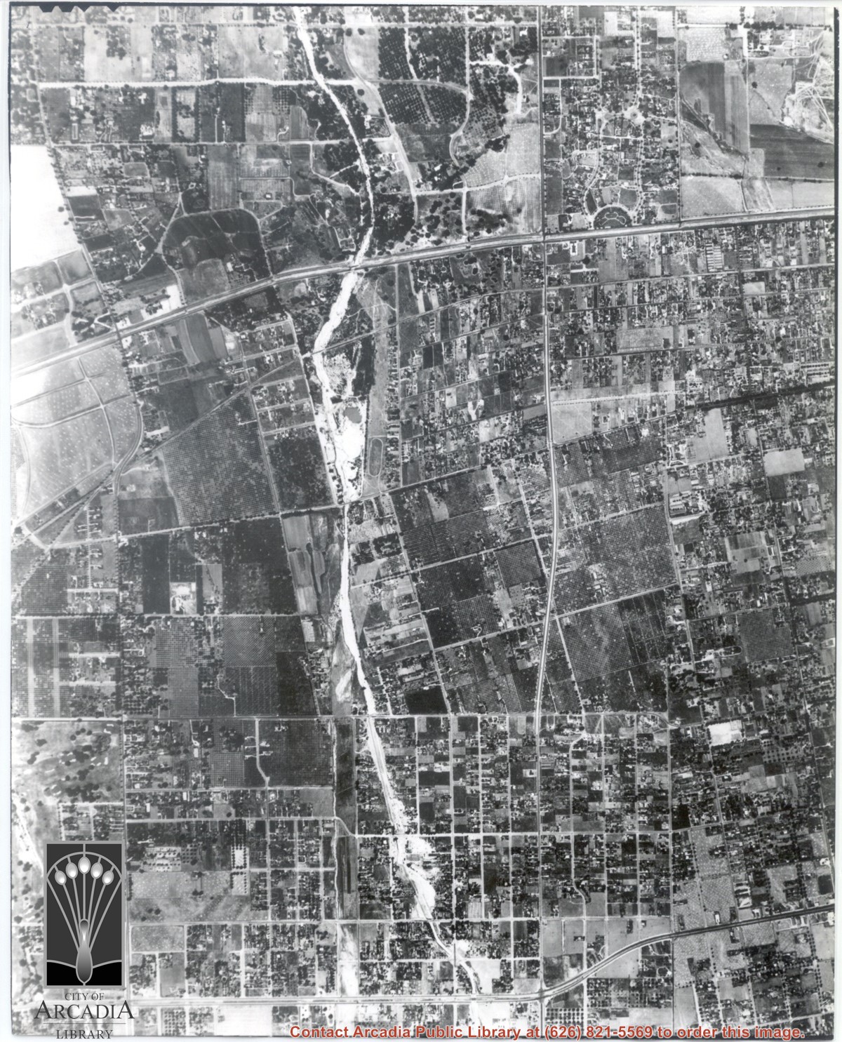
Main road crossing photo east to west in top third of photo is Huntington Drive. The main street running North/South in right portion of photo is Rosemead Boulevard. Wash running North/South is Eaton Wash. Very little in this view is of Arcadia.

https://arcadiahistory.andornot.com/en/permalink/photographs624
Date
June 5, 1938

  1 image

Date
June 5, 1938
Subjects
Aerial Photo Collection
Aerial views
Eaton Wash
Huntington Drive
Rosemead Boulevard
Physical Description
8x10 b&w
ID
620
Collection
Photographs
Images
Less detail

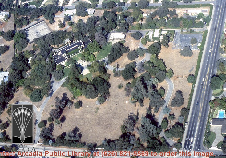
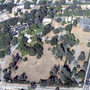
Aerial view, of Anita M. Baldwin's former estate known as Anoakia, looking north. Address was at 701 West Foothill Boulevard in Arcadia, when it was the Anoakia School. The street that runs north/south is North Baldwin Avenue. The street that runs east/west is Foothill Boulevard. Any use of this image must be credited "Photograph by David Stevens. Copyright David Stevens."

https://arcadiahistory.andornot.com/en/permalink/photographs2413
Date
1990?

  1 image

Date
1990?
Subjects
Aerial Photo Collection
Aerial views
Anoakia
Anoakia School
Baldwin, Anita M.
David Stevens Collection
Physical Description
color image, digital, see i:images
ID
2271A
Collection
Photographs
Images
Less detail

Anoakia annexation by Arcadia effort underway. Because of a law change, the major landholder can no longer determine an area's status. On January 21, 1975, a petition was presented signed by 33 registered voters in the area around Anoakia.

https://arcadiahistory.andornot.com/en/permalink/newspaper394
Newspaper
Arcadia Tribune
Date
January 19, 1975
January 29, 1975
Pages
p. 1
Newspaper
Arcadia Tribune
Date
January 19, 1975
January 29, 1975
Pages
p. 1
Subjects
Annexation (Municipal Government)
Item ID
394AN
Collection
Newspaper Index
Less detail

There is no print of this negative. The negative is a Baldwin tract map for the Santa Anita Colony. The 800 acres of Santa Anita Colony were bounded by today's Duarte Road on the north, Live Oak Avenue on the south, El Monte Avenue on the west and Second Avenue on the east.

https://arcadiahistory.andornot.com/en/permalink/photographs1444
Date
c.1891

  1 image

Date
c.1891
Subjects
Santa Anita Colony
Physical Description
4x6 negative only
ID
1431
Collection
Photographs
Images
Less detail

Arcadia voters overwhelmingly supported their schools in the tax base election held November 8. There was a heavy turnout, with over 80% of those eligible going to the polls.

https://arcadiahistory.andornot.com/en/permalink/newspaper2993
Newspaper
Arcadia Tribune
Date
November 10, 1977
Pages
p. A-1
Newspaper
Arcadia Tribune
Date
November 10, 1977
Pages
p. A-1
Subjects
Schools - Finance
Item ID
2918AN
Collection
Newspaper Index
Less detail

2024 ELECTIONS - Pasadena City College: Four candidates compete for two Board of Trustee seats on the March 5 election. Voters elect a trustess from each of the seven districts in an area that includes Arcadia, a portion of El Monte, La Canada Flintridge, Pasadena, Rosemead, San Marino, Sierra Madre, South Pasadena, and Temple City. Area 2 candidates are Kevin D. Strotz and James Aragon. Area 6 candidates are Ryan Liu and John Quintanilla.

https://arcadiahistory.andornot.com/en/permalink/newspaper36639
Newspaper
Pasadena Star News
Date
February 25, 2024
Pages
p. A3, A11

The general plan will be reviewed by the Planning Commission. The "central area" will be the focus of study. This area runs from the 210 Foothill freeway on the north to Duarte Road on the south and from the east city boundary to Santa Anita Avenue. It also includes the commercial section west of Santa Anita Avenue and north of Huntington Drive.

https://arcadiahistory.andornot.com/en/permalink/newspaper1176
Newspaper
Arcadia Tribune
Date
March 28, 1974
Pages
p. 1
Newspaper
Arcadia Tribune
Date
March 28, 1974
Pages
p. 1
Subjects
City Planning
Item ID
1175AN
Collection
Newspaper Index
Less detail

Arcadia City Council has approved the de-annexation of approximately five acres of property north of Hillcrest Boulevard. Monrovia gains the property that is included in a development proposal for the area.

https://arcadiahistory.andornot.com/en/permalink/newspaper407
Newspaper
Arcadia Tribune
Date
November 15, 1979
Pages
p. A-1
Newspaper
Arcadia Tribune
Date
November 15, 1979
Pages
p. A-1
Item ID
407AN
Collection
Newspaper Index
Less detail

Arcadia City Council has approved the de-annexation of approximately five acres of property north of Hillcrest Boulevard. Monrovia gains the property that is included in a development proposal for the area.

https://arcadiahistory.andornot.com/en/permalink/newspaper999
Newspaper
Arcadia Tribune
Date
November 15, 1979
Pages
p. A-1
Newspaper
Arcadia Tribune
Date
November 15, 1979
Pages
p. A-1
Subjects
City Council 1970 - 1979
Item ID
999AN
Collection
Newspaper Index
Less detail

View northeast over Pacific Electric Railroad. Ross Field Balloon School occupies portion on right side of photo over to the railroad tracks. The street marking its northern boundary would be Huntington Drive. The large rectangle just north of this street was Rancho Resevoir, converted into a swimming pool. The principal street marking east boundary of Balloon School property running north to south across this photo about at middle, is Santa Anita Avenue.

https://arcadiahistory.andornot.com/en/permalink/photographs634
Date
November, 1929

  1 image

Date
November, 1929
Subjects
Aerial Photo Collection
Aerial views
Balloon School
Pacific Electric Railway
Railroads
Ross Field
Physical Description
8x10 b&w
ID
630
Collection
Photographs
Images
Less detail

County Area west of City limits to Rosemead - known as West Arcadia annex #40.

https://arcadiahistory.andornot.com/en/permalink/newspaper3699
Newspaper
Arcadia Tribune
Date
February 2, 1967 p. 1
February 16, 1967 p. 1
February 23, 1967 p. 1
March 12, 1967 p. 1
March 16,1967 p. 1
March 19, 1967 p. 1
April 9, 1967 p. 1
April 13, 1967 p. 1
April 23, 1967 p. 1
May 4, 1967 p. 1
May 7, 1967 p. 1
May 14, 1967 p. 1
May 18, 1967 p. 1
June 11, 1967 p. 1
June 25, 1967 p. 1
July 20, 1967 p. 1
September 28, 1967 p. 1
October 1, 1967 p. 1
January 18, 1968 p. 1
January 21, 1968 p. 1
January 25, 1968 p. 1
February 8 1968 p. 1
March 17, 1968 p. 1
March 21, 1968 p. 1
March 28, 1968 p. 1 (protests)
April 18, 1968 p. 1 (defeated)
Subjects
Annexation (Municipal Government)
Item ID
3574AN
Collection
Newspaper Index
Less detail

20 records – page 1 of 1.