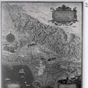
1. "Tour of Arcadia - Past and Present." Map prepared by Arcadia schools and given to the Library by Roberta Ramsell, August 1980. 2. Map of the San Pascual Plantation. Published 1870 in San Francisco.
1. Where Arcadia children learn their R's. news photo and art on school district staff. 1933. 2. Arcadia's first school house. news photo, n.d. 3. Arcadia schools struggle to keep up with growth in community. 1903-E.J. Baldwin donated barn near Huntington Drive and South Santa Anita. First of…
1. Where Arcadia children learn their R's. news photo and art on school district staff. 1933.
2. Arcadia's first school house. news photo, n.d.
3. Arcadia schools struggle to keep up with growth in community. 1903-E.J. Baldwin donated barn near Huntington Drive and South Santa Anita. First official school building in Arcadia was a two-room bungalow at First Avenue and California Street. Arcadia Tribune May 24, 1949.
4. Enrollment of 125 in schools. Arcadia Journal September 14, 1918.
5. Two-room bungalow called Arcadia's first official school building. news photo, n.d.
6. Original section of First Avenue School. news photo, n.d.
7. Historical society marks school site. news clip and photo October 3, 1963.
8. Profile of a city and its schools. History of Arcadia schools by D. Pinney April 1959.
9. Arcadia school old-timers to hold reunion. Los Angeles Times June 24, 1962.
10. One of the highlights of the 60th anniversary celebration of Arcadia. Arcadia Tribune photo and caption June 24, 1962.
11. Directory of Public Schools of Los Angeles County, CA. pages applicable to Arcadia November 1925.
12. Arcadia's first school on Falling Leaf Avenue. news photo and article August 4, 1933.
13. Arcadia completes fine grammar school. Arcadia Journal May 7, 1921.
14. Sierra Madre's early school days. TV news clip October 1973?
15. This painting of the original class of First Avenue School in Arcadia. Photo with identification of pupils attached. News-Post, n.d.
16. Presented in recognition of California Public Schools Week by Arcadia Chamber of Commerce. news clip, n.d. (circa 1948?)
17. Arcadia schools. page from San Gabriel Valley Digest, April 1930.
18. Arcadia's first back to school days. page from TV facts September 16, 1973? photo and text about first school.
19. Unique alumni group welcomes former Baldwin-era residents. Arcadia Tribune, n.d. (circa 1963)
20. Students, teachers, district meet and overcome obstacles. Arcadia Tribune September 14, 1978.
21. First Avenue class graduates before honored guests from first graduation. Arcadia Tribune June 16, 1946.
22. Queen City's schools: growth through the years. Arcadia Tribune May 18, 1978.
23. Ranch School. Note regarding school on the Lucky Baldwin ranch and number of pupils - 1880; taken from Carew, HISTORY OF PASADENA AND SAN GABRIEL VALLEY.
24. Mrs. Finley is teaching a school of 12 pupils in the new lodging house. news clip in a column in the San Gabriel Valley News entitled Santa Anita. May 9, 1878.
25. Arcadia Grammar School children win essay prizes. news clip regarding participation in essay contest sponsored by electrical industry of the U.S. 1924.
26. Closing School Days. Arcadia Journal June 21, 1919.
27. Program of musical given at San Joaquin School. Made from original owned by Adrian Winkler who participated in program May 27, 1924; received February 1981. (Arcadia School District Office knows nothing about this school as of January 1981, yet it is listed in the 1923 City Directory.)
28. Information from the 1923 City Directory regarding Santa Anita Grammar School in San Joaquin Street.
29. Lived here 60 years. Arcadia Tribune n.d. Regarding San Joaquin School.
30. Arcadia School District Chronology. received July 5, 1985.
31. Public Schools Week. Pamphlet with historic photos of schools April 21-25, 1975.
32. Arcadia City Schools Eighth Grade Graduation Exercises program June 13, 1924.
33. Auditor's Semi-Annual report for Santa Anita School District, six months ending December 31, 1890. photocopy courtesy Don Chapat.
34. same. Six months ending June 30, 1890.
35. State of California Teacher's Public School Register of Arcadia City School District, County of Los Angeles, California, 1901-1911. Includes records of attendance, teacher's reports, reports of classification and grading of pupils, visitors' records, list of apparatus and other school property, principal's reports, daily programs, and miscellaneous blank forms.
NOTE: Unless otherwise noted, all items are street maps. Items preceded by (*) are housed in Arcadia History Box 53 and are available for viewing by appointment only. Also some duplicates of maps in folder will be found in Box 53. Most issues of the Arcadia City Directory also contain maps. Fo…
NOTE: Unless otherwise noted, all items are street maps. Items preceded by (*) are housed in Arcadia History Box 53 and are available for viewing by appointment only. Also some duplicates of maps in folder will be found in Box 53. Most issues of the Arcadia City Directory also contain maps. For further assistance, see the Local History Librarian.
1. * 1950
2. *1951
3. * 1954
4. 4a. 1952 Map of Arcadia furnished by City of Arcadia for distribution through Arcadia Chamber of Commerce 37 West Huntington Drive; 4b. 1955 - original in Archives VF.
5. 1955
6. 1956
7. 1957
8 * 1958
9. *1959
10. *1961
11. 1962
12. 1964
13. * 1965
14. 1965
15. 1966
16. 1968
17. 1969
18. 1970-1971 (2 copies)
19. 1971-1972
20. 1973 (2 copies)
21. 1974 (2 copies)
22. 1976
23. 1977
24. *1968 - precinct index.
25. 1960 (missing 4/15/03)
26. Arcadia map book pages, undated. Original in Archives VF.
27. 1974 - copies of map transparencies. Originals in Archives VF.
28. 1978
29. Area-wide map showing freeways, undated.
30. * circa 1989.
31. 1987-1988
31A. 1986 map official Chamber of Commerce map of Arcadia.
32. * Flooding hazards map, 1975. Also found in Arcadia General Plan, 1975, R 711.4A.
33. * Seismic hazards map, 1975. Also found in Arcadia General Plan, 1975, R 711.4A.
34. * 1979-1980
35. 1984 (2 copies)
36. "Arcadia Home of the Equestrian 1984 Olympics" map.
37. Security-First National California Motor Route Map with detailed Automobile Highway Maps of Southern California, Los Angeles and Vicinity and the entire state of California, undated.
38. 1963 Map of Arcadia, includes city statistics.
39. 1979-80 Arcadia, CA city map and business directory, published by Arcadia Chamber of Commerce.
40. 1971 San Gabriel Valley map distributed by Shepard & Morgan Realtors and Builders.
41. 1977-1978 Arcadia City Map & Business Directory published by Arcadia Chamber of Commerce, celebrating Arcadia's Diamond Jubilee, or 75th Birthday.
42. Arcadia Unified School District Elementary and Middle School Boundaries and Zones map. Copyright 1973. 2 copies.
All items are street maps unless otherwise noted. 1. 1990-1991 2. 1992-1993 3.1994-1995 4. 1995-1996 5. 1996-1997 6. 1999 7. Thomas Bros. Maps Los Angeles and Orange Counties fold-out map, showing freeway system, copyright 1997.
All items are street maps unless otherwise noted.
1. Official City Map of Arcadia Centennial 1903-2003 2. California City Map featuring the cities of Arcadia and E. San Gabriel. 2002 edition. 3. City of Arcadia & Los Angeles County, 2008. 4. The City of Arcadia & Los Angeles County. Undated. c…
All items are street maps unless otherwise noted.
1. Official City Map of Arcadia Centennial 1903-2003
2. California City Map featuring the cities of Arcadia and E. San Gabriel. 2002 edition.
3. City of Arcadia & Los Angeles County, 2008.
4. The City of Arcadia & Los Angeles County. Undated. c. 2009. Map provided by Hometown Productions & Premier Map Company.
5. Arcadia, CA. Official City Map, published by Arcadia Chamber of Commerce. c. 2007. Verified advertiser Cynthia's Afternoon Tea Room was listed in 2007 Arcadia yellow pages directory.
All items are street maps unless otherwise noted. 1. The City of Arcadia and Los Angeles County map, c. 2015. 2. Arcadia street map, 2015. Pull-out map from Arcadia Chamber of Commerce Community Profile. 3. Arcadia Downtown Business Association Visitor's Guide to Downtown Arcadia, c. 2018. 4. Pages…
1. The City of Arcadia and Los Angeles County map, c. 2015.
2. Arcadia street map, 2015. Pull-out map from Arcadia Chamber of Commerce Community Profile.
3. Arcadia Downtown Business Association Visitor's Guide to Downtown Arcadia, c. 2018.
4. Pages 537, 566, 567, 597 from The Thomas Guide Los Angeles & Orange Counties street guide, by Rand McNally, 2013 showing Arcadia street map.
5. Downtown Arcadia map, updated January 2018, by the Downtown Arcadia Improvement Association. 2 copies.
6. Current Land Use Map Zoning Map of Arcadia from Arcadia General Plan Update, 2010.
7. Arcadia Chamber of Commerce Map of Arcadia, 2011.
8. Zoning Map of the City of Arcadia. Updated December 6, 2017.
9. Map of Arcadia, include street map and foothills area map. Pulled out from the 2019 Arcadia Chamber of Commerce Community Profile and Business Resource Guide.
10. Color map of Arcadia with Lodging Guide that includes addresses and phone numbers on one side, and map of Downtown Arcadia on the other that lists restaurants and nightlife, shops and services, including addresses and phone numbers. Prepared by the Downtown Arcadia Improvement Association (DAIA). c.2018.
a. Property Ownership Maps. No. 1-16; with Index (Prior to October, 1972)
b. Property Ownership Maps. No. 16A-37B
c. Property Ownership Maps. No. 38-58
d. Board Roll of State Assessed Property. Prepared by the State Board of Equalization, State of California. City of Arcadia. 1954. Includes letter…
a. Property Ownership Maps. No. 1-16; with Index (Prior to October, 1972)
b. Property Ownership Maps. No. 16A-37B
c. Property Ownership Maps. No. 38-58
d. Board Roll of State Assessed Property. Prepared by the State Board of Equalization, State of California. City of Arcadia. 1954. Includes letter to Mr. Walter Cornish, Arcadia City Clerk from Broley E. Travis, Chief, Valuation Division, Sept 17, 1954.
e. Assessment Roll of Property. Assessed by the State Board of Equalization. State of California. City of Arcadia. 1947-1954.
f. Assessment Book of the Property of the City of Arcadia, Los Angeles County, for the years 1904-1908
All items in Box 84 came from the Arcadia City Hall vaults, given to the Arcadia Public Library in July, 2004.
1. Kingsley map of Rancho, Section II. Surveyed March 1910. 2. Kingsley map of Rancho, Section III. Surveyed March 1910. 3. Boundaries of Hugo Reid's original 13,316 acre Rancho Santa Anita. Lasca Leaves, September 1975. 4. Rancho as sketch outlines by Lupe Cuellar. Copy received 1967. 5. Ranc…
The library does not have a print of this negative. This oversized negative is marked 1923 Official Map of the City of Arcadia. It appears to have been produced by the City Engineer.
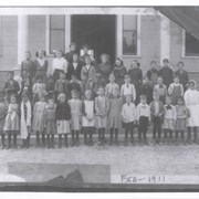
Students at Arcadia Grammar School, where present First Avenue Middle School is now. Built in 1907, this building replaced the packing shed school provided earlier by E.J. Baldwin. This school was located at the southwest corner of First Avenue and California Street. No identification of teachers or students.
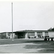
View east of the front of Santa Anita School, probably shortly after its opening, as shrubbery is small. This school was located at 1900 S. Santa Anita Avenue from about the late 1940s until June 1981. Santa Anita School was built on the site of the second school building built by the City, a two-room red brick building, built in 1913 to house grades 1 and 2. In 1982, Arcadia Christian School moved into this location.
Maps shift election shapes. Redistricting offers little for Democrats to fear but comes as retirements open doors. Final maps were released yesterday to redraw boundaries for California's elected seats in Sacramento and Washington DC. The 14-member independent California Citizens Redistricting Commission's maps set up newly drawn Assembly, State Senate and Congressional maps, which must be formally approved. The maps did little to loosen Democrats' hold on Los Angeles County's state and federal districts. On the State Senate level, where the Commission is tasked with creating districts with 1 million people each, state Senator Susan Rubio's vast San Gabriel Valley District 22 loses several heavily Asian American communities, including San Gabriel, Alhambra, Monterey Park, Rosemead and Arcadia. Those communities would join Pasadena, Glendale and Altadena in Senator Anthony Portantino's District 25.
TV's Mario Lopez to host Lucky Baldwin Poker Tournament on June 10. It is a fundraiser to preserve the 1880s architecture of Elias J. "Lucky" Baldwin's home at the site of Los Angeles County Arboretum and Botanic Garden.