Skip header and navigation

11 records – page 1 of 1.

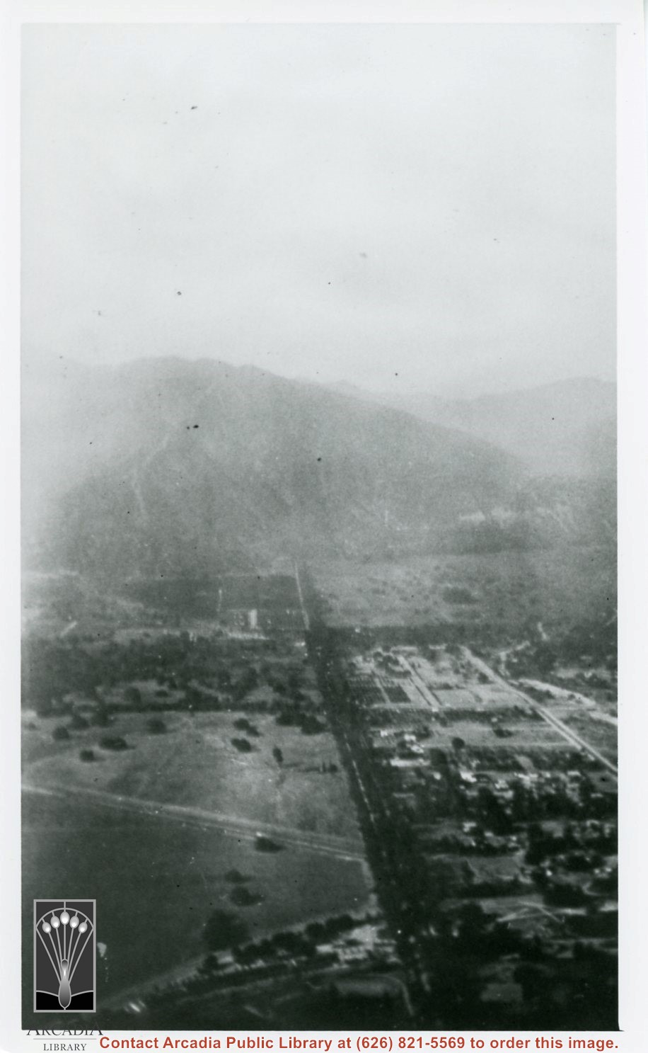
Aerial view north up Santa Anita Avenue. Note Chantry Flats Road on mountain near right side of photo. This view was taken from just south of Huntington Drive. This image belongs to Arcadia Historical Society.

https://arcadiahistory.andornot.com/en/permalink/photographs587
Date
November 1926

  1 image

Date
November 1926
Subjects
Aerial Photo Collection
Aerial views
Chantry Flats Road
Santa Anita Avenue
Physical Description
6x10 vertical
ID
583
Collection
Photographs
Images
Less detail

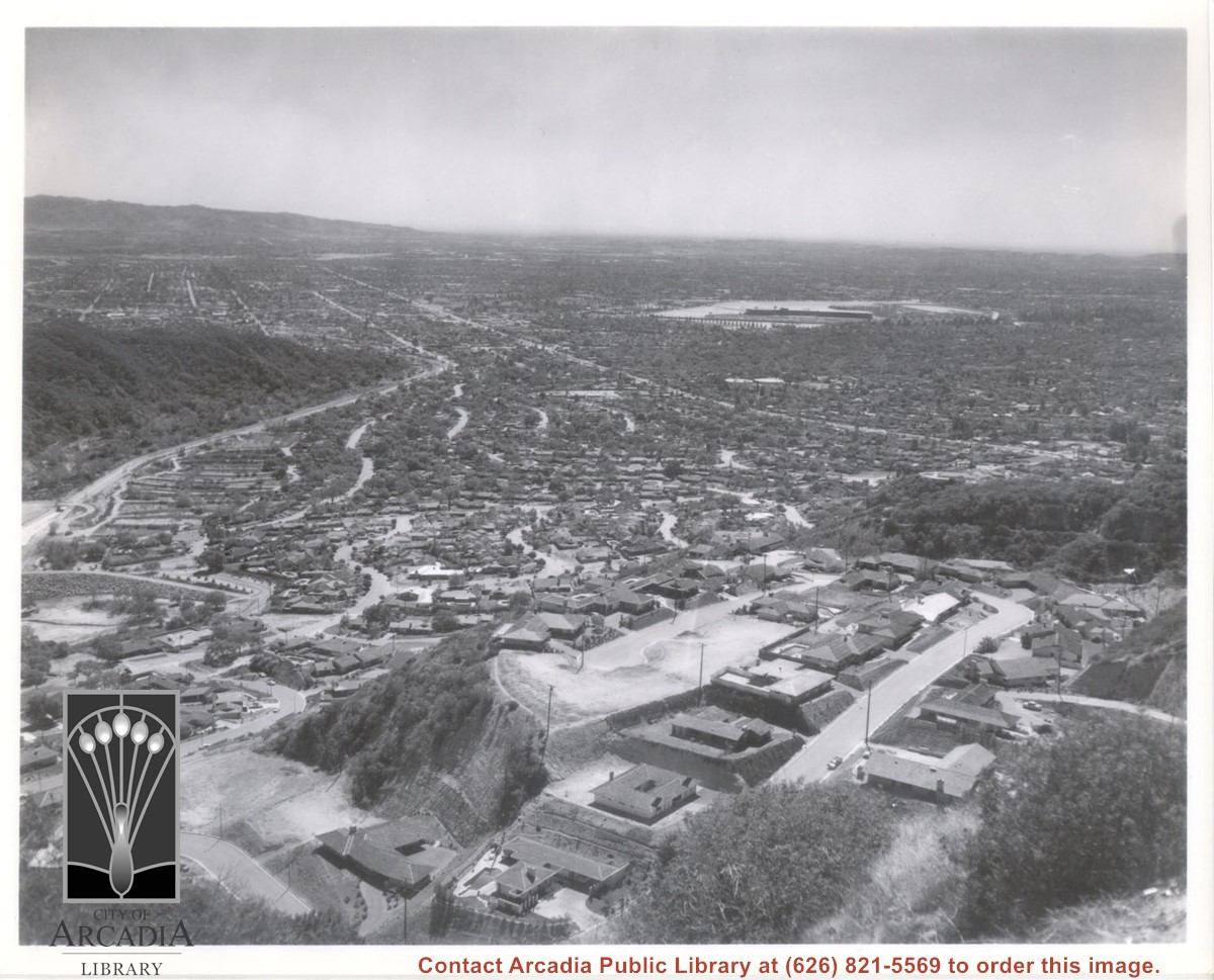
Aerial view south from Chantry Flats Road over the still-developing upper Highlands section of Arcadia. View is across Arcadia toward the Puente Hills. Santa Anita Park Race Track is seen in the center. Santa Anita Wash is seen on extreme left.

https://arcadiahistory.andornot.com/en/permalink/photographs955
Date
c.1965

  1 image

Date
c.1965
Subjects
Aerial Photo Collection
Aerial views
Arcadia(City)-History-1960-1969
Chantry Flats Road
Santa Anita Wash
Physical Description
8x10 b&w
ID
949
Collection
Photographs
Images
Less detail

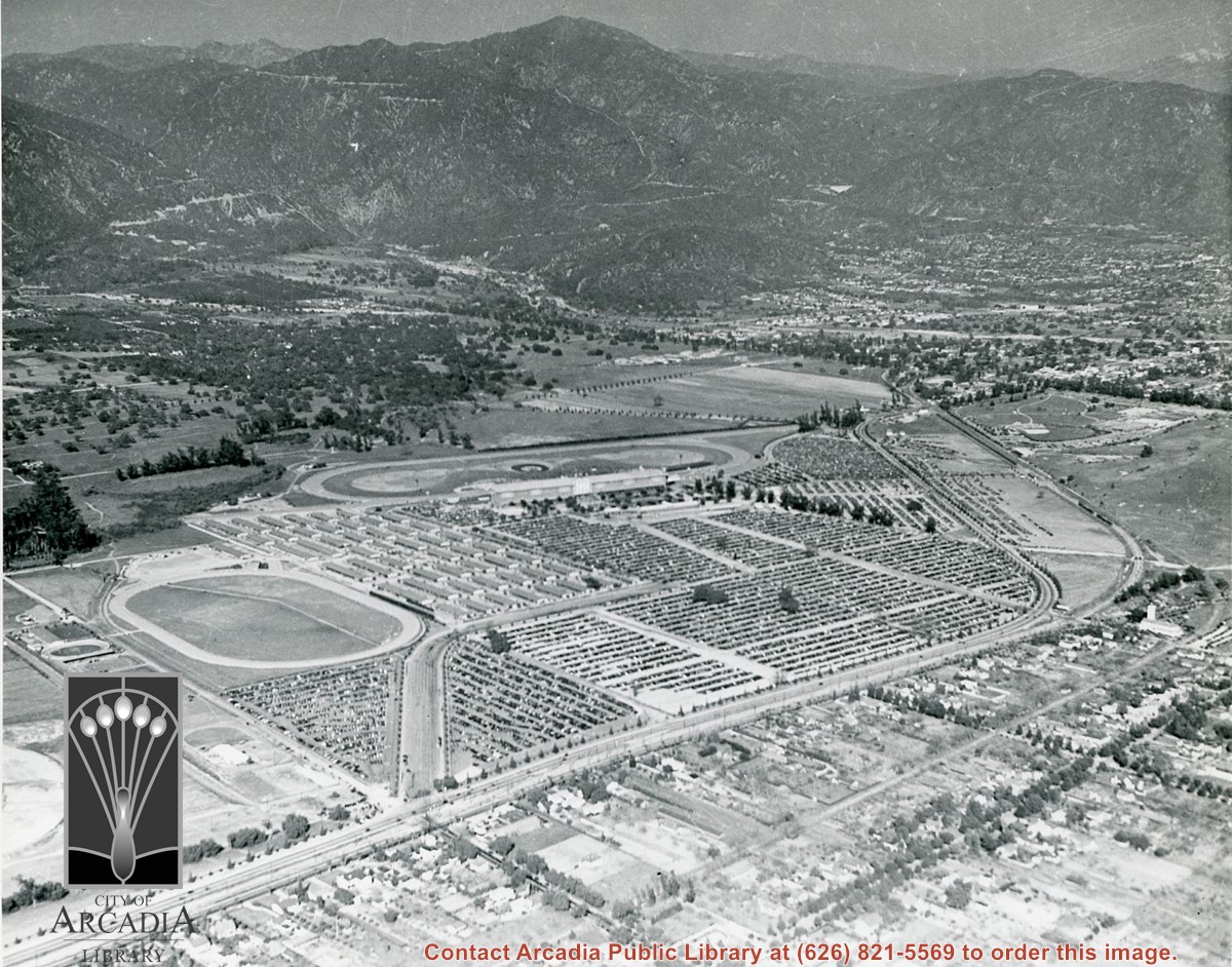
Aerial view toward NE. Main thoroughfare cutting across east to west with young trees planted on north side, is Huntington Drive. Main race track at Santa Anita is seen almost directly in center of photo, with Club House on side closest to camera. The smaller oval near left edge of photo was a training track belonging to Santa Anita which was removed for the Fashion Park. The Chantry Flats Road up to Santa Anita Canyon is clearly seen as it zig-zags around San Gabriel Mountains. This photo belongs to the Huntington Library. It is shown here for research only.

https://arcadiahistory.andornot.com/en/permalink/photographs629
Date
c. 1940s

  1 image

Date
c. 1940s
Subjects
San Gabriel Mountains
Santa Anita Park-1934-1942
Chantry Flats Road
Huntington Drive
Fashion Park
Physical Description
8x10 b&w
ID
625
Collection
Photographs
Images
Less detail

Aerial view toward north from a position south of Huntington Drive near intersection with Baldwin Avenue. It shows Santa Anita Fashion Park (currently known as Westfield Santa Anita Shopping Mall) developed by and on property owned by Santa Anita Consolidated. The Santa Anita Park Race Track and club house can be seen in center of photo. The straight white line about one inch above the club house roof is 210 Foothill Freeway. Chantry Flats road can be seen going up into San Gabriel Mountains in distance.

https://arcadiahistory.andornot.com/en/permalink/photographs646
Date
c. 1975

  1 image

Chantry Flat Road, also known as Santa Anita Canyon Road, will reopen to the public on Wednesday, April 16, despite unfinished repairs. Fire in the Santa Anita Canyon had forced a 6-month closure of the road.

https://arcadiahistory.andornot.com/en/permalink/newspaper31236
Newspaper
Arcadia Weekly
Date
April 17, 2003
Pages
p. 19
Newspaper
Arcadia Weekly
Date
April 17, 2003
Pages
p. 19
Subjects
Chantry Flat Road
Santa Anita Canyon Road
United States Forest Service
Item ID
31429AN
Collection
Newspaper Index
Less detail

The City Council approved funding for a new guardrail along Santa Anita Canyon Road, where a motorist drove over a mountainside last year. Federal funds will cover 90% of the new guardrail costs, and the new guardrail could be in place as early as spring.

https://arcadiahistory.andornot.com/en/permalink/newspaper3393
Newspaper
Arcadia Tribune
Date
December 23, 1990
Pages
p. A-1
Newspaper
Arcadia Tribune
Date
December 23, 1990
Pages
p. A-1
Subjects
Streets - Chantry Flat Road
Item ID
3283AN
Collection
Newspaper Index
Less detail

Santa Anita Canyon Road, aka Chantry Flat Road, has been jointly owned by Arcadia, Sierra Madre, Monrovia, and Los Angeles County for years. The 3-mile mountain road that leads to the Angeles National Forest will be turned over to Los Angeles County if the cities pay to fix it up. Arcadia and Sierra Madre have completed their repairs and are waiting for Monrovia to start a roughly $500,000 project.

https://arcadiahistory.andornot.com/en/permalink/newspaper31867
Newspaper
Pasadena Star News
Date
January 18, 2010
Pages
p. A3
Newspaper
Pasadena Star News
Date
January 18, 2010
Pages
p. A3
Subjects
Chantry Flat Road
Santa Anita Canyon Road
Item ID
32064AN
Collection
Newspaper Index
Less detail

Seven months after Chantry Flat Road was closed at night, the noise that bothered residents and the injuries from auto accidents have virtually ceased.

https://arcadiahistory.andornot.com/en/permalink/newspaper3391
Newspaper
Arcadia Tribune
Date
December 23, 1987
Pages
p. A-1
Newspaper
Arcadia Tribune
Date
December 23, 1987
Pages
p. A-1
Subjects
Streets - Chantry Flat Road
Item ID
3281AN
Collection
Newspaper Index
Less detail

Several cities including Arcadia, Monrovia and Sierra Madre and Los Angeles County are coordinating efforts to repair damage from heavy rains on Chantry Flat Road. Arcadia owns two stretches of the road. Arcadia and Monrovia are asking FEMA, the Federal Emergency Management Agency, for funds.

https://arcadiahistory.andornot.com/en/permalink/newspaper29455
Newspaper
Pasadena Star News
Date
March 30, 2005
Pages
p. A1
Newspaper
Pasadena Star News
Date
March 30, 2005
Pages
p. A1
Subjects
Chantry Flat Road
Roads--closures
Big Santa Anita Canyon
Item ID
29640AN
Collection
Newspaper Index
Less detail

Susan Clavey, the mother of Tanya Clavey (the 16-year old girl who died following a 400-foot plunge off the Santa Anita Canyon Road) asked the Arcadia City Council to close the road's gate at dusk to prevent further fatalities. The gate, normally locked at 10 PM, was unlocked when the accident occurred at 10:15 PM.

https://arcadiahistory.andornot.com/en/permalink/newspaper3392
Newspaper
Arcadia Tribune
Date
November 26, 1989
Pages
p. A-1
Newspaper
Arcadia Tribune
Date
November 26, 1989
Pages
p. A-1
Subjects
Streets - Chantry Flat Road
Item ID
3282AN
Collection
Newspaper Index
Less detail

View across Arcadia taken from Chantry Flats Road at night. Long diagonal streak starting near bottom of lower right, marks Santa Anita Avenue.

https://arcadiahistory.andornot.com/en/permalink/photographs1159
Date
c.1952

  1 image

Date
c.1952
Subjects
Aerial Photo Collection
Aerial views
Arcadia(City)-History-1950-1959
Chantry Flats Road
Physical Description
5x10 b&w
ID
1150
Collection
Photographs
Images
Less detail

11 records – page 1 of 1.