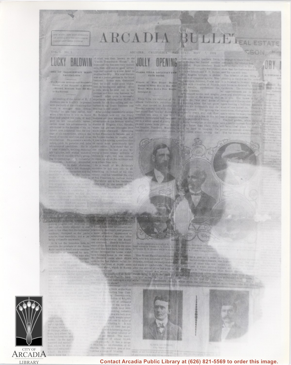
Volume I no. 1 issue of first Arcadia newspaper, THE ARCADIA BULLETIN. Paper included an article on the opening of Clara Villa which opened May 3, 1904. The paper has photos of five members of the Board of Trustees (now City Council) and also one of Arcadia's first City Marshall, Elmer Anderson and his brother, Charles Anderson, City Treasurer.
https://arcadiahistory.andornot.com/en/permalink/photographs1093
- Date
- May 7, 1904
1 image
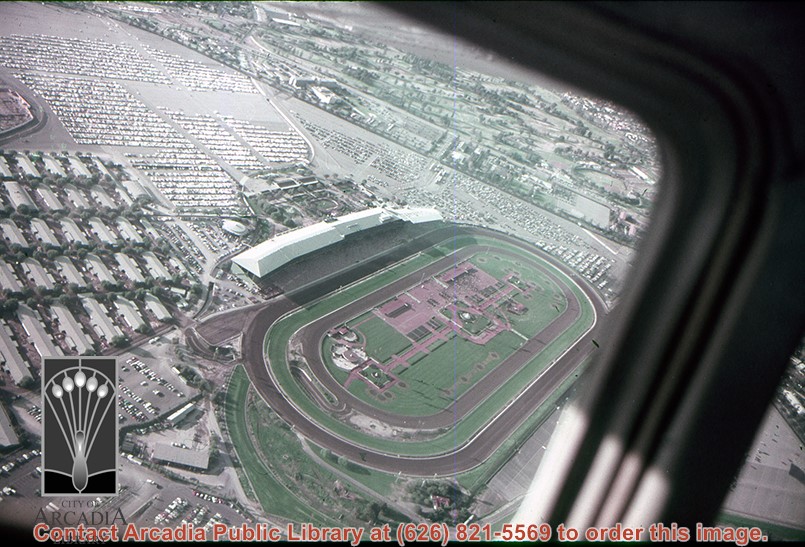
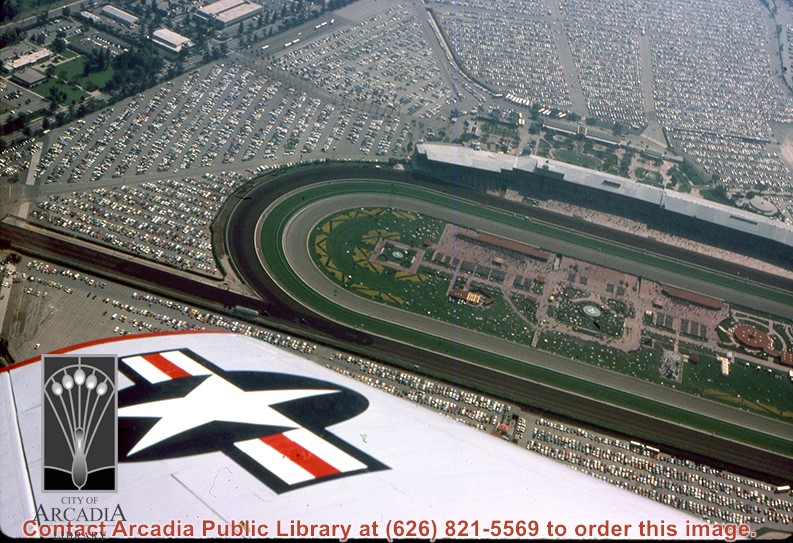
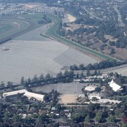
Aerial view, of Santa Anita Park Race Track, address is 285 West Huntington Drive, Arcadia, California. Any use of this image must be credited "Photograph by David Stevens. Copyright David Stevens."
https://arcadiahistory.andornot.com/en/permalink/photographs2417
- Date
- 1990?
1 image
- Date
- 1990?
- Physical Description
- color image, digital, see i:images
- ID
- 2275
- Collection
- Photographs
Images
Aerial view, of Santa Anita Park Race Track, address is 285 West Huntington Drive, Arcadia, California. Many cars are parked there. Any use of this image must be credited "Photograph by David Stevens. Copyright David Stevens."
https://arcadiahistory.andornot.com/en/permalink/photographs2418
- Date
- 1990?
1 image
- Date
- 1990?
- Physical Description
- color image, digital, see i:images
- ID
- 2276
- Collection
- Photographs
Images
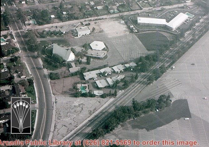
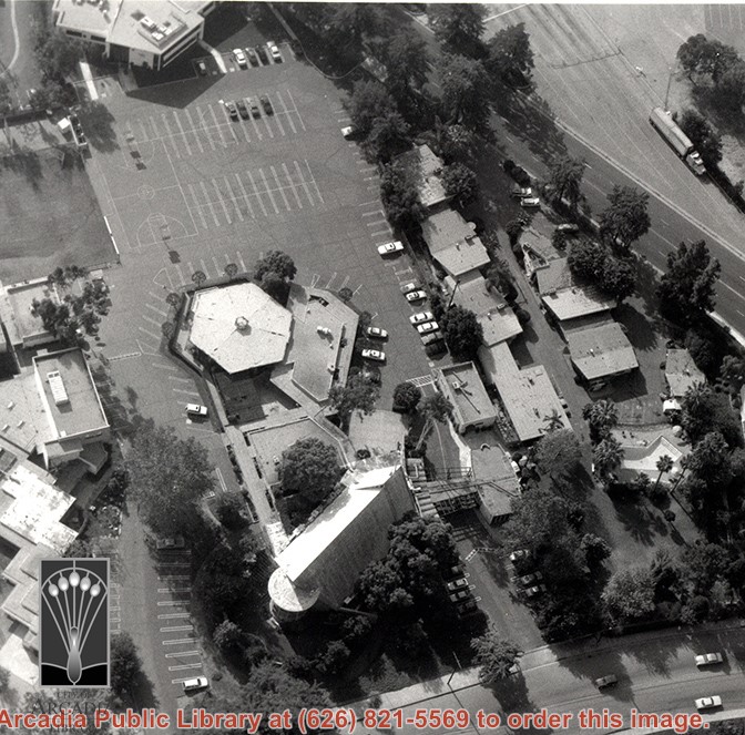
Aerial view, of the white A-Frame roof of Santa Anita Church (address is 226 West Colorado Boulevard, Arcadia, California). The Fireside Room and Fellowship Hall is the building with a hexagonal roof, seen to the right of Santa Anita Church. Any use of this image must be credited "Photograph by David Stevens. Copyright David Stevens."
https://arcadiahistory.andornot.com/en/permalink/photographs2419
- Date
- 1990?
1 image
- Date
- 1990?
- Physical Description
- color image, digital, see i:images
- ID
- 2277
- Collection
- Photographs
Images
Aerial view, of the white A-Frame roof of Santa Anita Church (address is 226 West Colorado Boulevard, Arcadia, California). A six-sided, hexagon building near Santa Anita Church is the Fireside Room and Fellowship Hall, which is part of the Santa Anita Church. Any use of this image must be credited "Photograph by David Stevens. Copyright David Stevens."
https://arcadiahistory.andornot.com/en/permalink/photographs2420
- Date
- 1990?
1 image
- Date
- 1990?
- Physical Description
- color image, digital, see i:images
- ID
- 2278
- Collection
- Photographs
Images
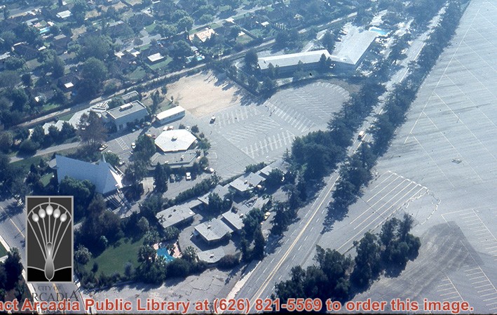
Aerial view, of the white A-Frame roof of Santa Anita Church (address is 226 West Colorado Boulevard, Arcadia, California). A six-sided, hexagon building near Santa Anita Church is the Fireside Room and Fellowship Hall, which is part of the Santa Anita Church. The church property goes all the way to Colorado Place (including "The Village Apartments," formerly the Frontier Motel, which the church purchased in 1972) and includes the parking lot and the building at the top of the photo, the Margaret Stevens Center. Any use of this image must be credited "Photograph by David Stevens. Copyright David Stevens."
https://arcadiahistory.andornot.com/en/permalink/photographs2421
- Date
- 1990?
1 image
- Date
- 1990?
- Physical Description
- color image, digital, see i:images
- ID
- 2279
- Collection
- Photographs
Images
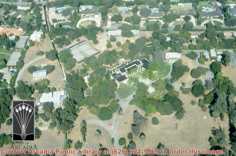
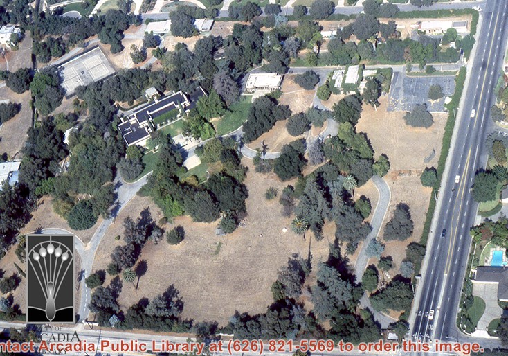
Aerial view, of Anita M. Baldwin's former estate known as Anoakia, looking north. Address was at 701 West Foothill Boulevard in Arcadia, when it was the Anoakia School. Any use of this image must be credited "Photograph by David Stevens. Copyright David Stevens."
https://arcadiahistory.andornot.com/en/permalink/photographs2411
- Date
- 1990?
1 image
- Date
- 1990?
- Subjects
- Aerial Photo Collection
- Aerial views
- Anoakia
- Anoakia School
- Baldwin, Anita M.
- David Stevens Collection
- Physical Description
- color image, digital, see i:images
- ID
- 2271
- Collection
- Photographs
Images
Aerial view, of Anita M. Baldwin's former estate known as Anoakia, looking south. Address was at 701 West Foothill Boulevard in Arcadia, when it was the Anoakia School. Any use of this image must be credited "Photograph by David Stevens. Copyright David Stevens."
https://arcadiahistory.andornot.com/en/permalink/photographs2412
- Date
- 1990?
1 image
- Date
- 1990?
- Subjects
- Aerial Photo Collection
- Aerial views
- Anoakia
- Anoakia School
- Baldwin, Anita M.
- David Stevens Collection
- Physical Description
- color image, digital, see i:images
- ID
- 2272
- Collection
- Photographs
Images
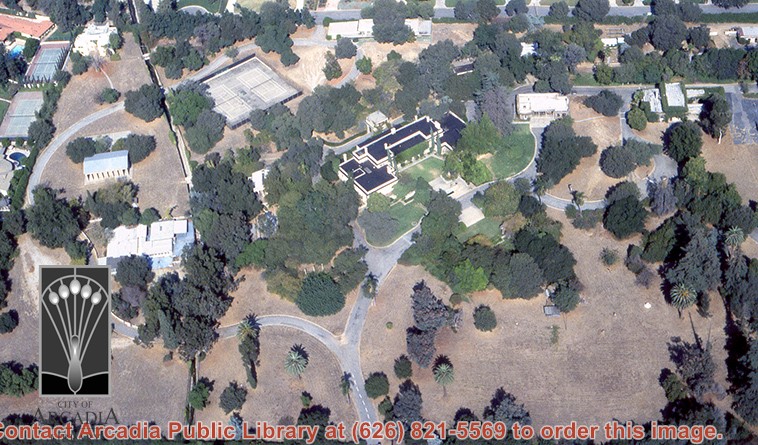
Aerial view, of Anita M. Baldwin's former estate known as Anoakia, looking north. Address was at 701 West Foothill Boulevard in Arcadia, when it was the Anoakia School. The street that runs north/south is North Baldwin Avenue. The street that runs east/west is Foothill Boulevard. Any use of this image must be credited "Photograph by David Stevens. Copyright David Stevens."
https://arcadiahistory.andornot.com/en/permalink/photographs2413
- Date
- 1990?
1 image
- Date
- 1990?
- Subjects
- Aerial Photo Collection
- Aerial views
- Anoakia
- Anoakia School
- Baldwin, Anita M.
- David Stevens Collection
- Physical Description
- color image, digital, see i:images
- ID
- 2271A
- Collection
- Photographs
Images
Aerial view, of Anita M. Baldwin's former estate known as Anoakia, looking north. Address was at 701 West Foothill Boulevard in Arcadia, when it was the Anoakia School. Any use of this image must be credited "Photograph by David Stevens. Copyright David Stevens."
https://arcadiahistory.andornot.com/en/permalink/photographs2414
- Date
- 1990?
1 image
- Date
- 1990?
- Subjects
- Aerial Photo Collection
- Aerial views
- Anoakia
- Anoakia School
- Baldwin, Anita M.
- David Stevens Collection
- Physical Description
- color image, digital, see i:images
- ID
- 2272A
- Collection
- Photographs
Images
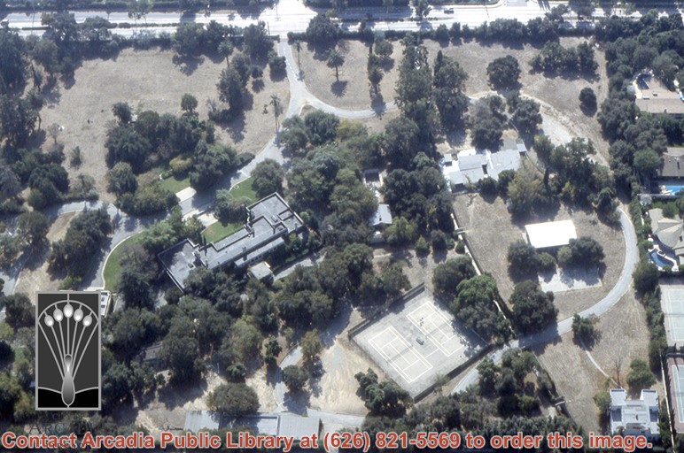
Aerial view, of Anita M. Baldwin's former estate known as Anoakia, looking west. Address was at 701 West Foothill Boulevard in Arcadia, when it was the Anoakia School. Street on the left is Foothill Boulevard? Gatehouse in the lower left corner? Any use of this image must be credited "Photograph by David Stevens. Copyright David Stevens."
https://arcadiahistory.andornot.com/en/permalink/photographs2415
- Date
- 1990?
1 image
- Date
- 1990?
- Subjects
- Aerial Photo Collection
- Aerial views
- Anoakia
- Anoakia School
- Baldwin, Anita M.
- David Stevens Collection
- Physical Description
- color image, digital, see i:images
- ID
- 2273
- Collection
- Photographs
Images
Aerial view, of Santa Anita Park Race Track in the upper left quadrant (address is 285 West Huntington Drive) and the white A-Frame roof of Santa Anita Church (address is 226 West Colorado Boulevard) in the lower right quadrant. A six-sided, hexagon building seen to the left of Santa Anita Church, is the Fireside Room and Fellowship Hall, which is part of the Santa Anita Church. Any use of this image must be credited "Photograph by David Stevens. Copyright David Stevens."
https://arcadiahistory.andornot.com/en/permalink/photographs2416
- Date
- 1990?
1 image
- Date
- 1990?
- Subjects
- Aerial Photo Collection
- Aerial views
- David Stevens Collection
- Santa Anita Church
- Santa Anita Park
- Physical Description
- color image, digital, see i:images
- ID
- 2274
- Collection
- Photographs
Images

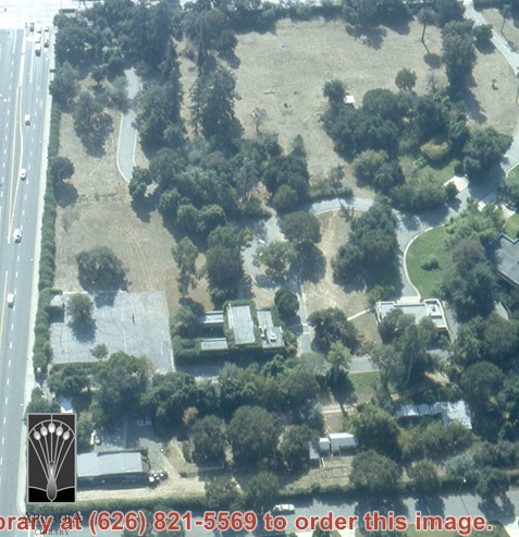
Aerial view toward NE. Plane is over property of Charles W. Stewart (10 acres), and Jaspar Teague (10 acres), at 1320 S. Santa Anita Avenue, which is directly under the plane. Next street east is First Avenue, then Second Avenue, the Fourth Avenue. Reservoir is at corner of Valnett Avenue and Second Avenue and was owned by Walnut Grove Mutual Water Company (Valnett Avenue was first through street south of Duarte Road at this time and became Camino Real).
https://arcadiahistory.andornot.com/en/permalink/photographs644
- Date
- November 1929
1 image
- Date
- November 1929
- Subjects
- Aerial Photo Collection
- Aerial views
- Camino Real
- Duarte Road
- First Avenue
- Fourth Avenue
- Second Avenue
- Santa Anita Avenue (South)
- Stewart, Charles W.
- Teague, Jaspar
- Valnett Avenue
- Physical Description
- 6x10 b&w
- ID
- 640
- Collection
- Photographs
Images

