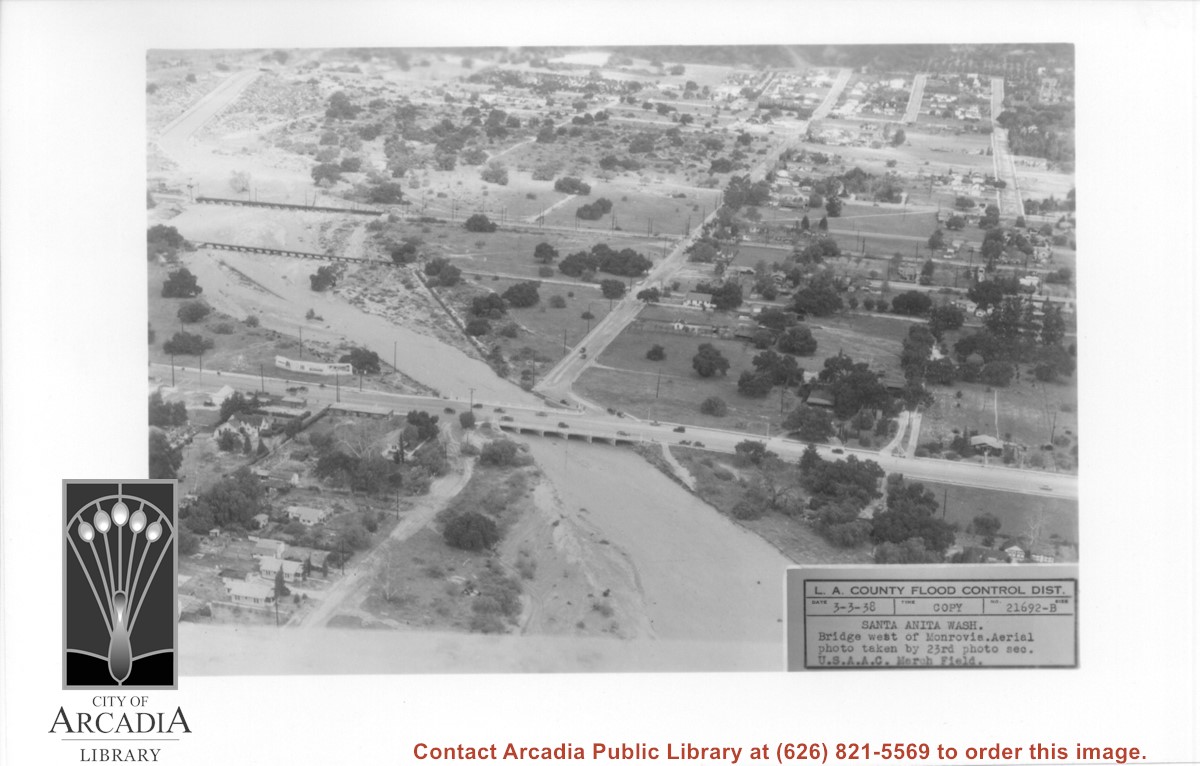
Aerial view looking north over flooded Santa Anita Wash looking upstream. Street cutting across photo closest to bottom is Huntington Drive. The next crossing upstream carries Santa Fe Railroad track. The last crossing that is clearly visible is Pacific Electric Railroad bridge. North/south street crossing Huntington Drive nearest wash would be Fifth Avenue. Foothill Boulevard is just barely visible near top of photo.
https://arcadiahistory.andornot.com/en/permalink/photographs815
- Date
- March 3, 1938
1 image
- Date
- March 3, 1938
- Subjects
- Aerial Photo Collection
- Aerial views
- Fifth Avenue
- Flood control
- Foothill Boulevard
- Huntington Drive
- Railroads
- Santa Anita Wash
- Physical Description
- 5x7 b&w
- ID
- 809
- Collection
- Photographs
Images
- Newspaper
- Arcadia Tribune
- Date
- April 23, 1962
- Pages
- p. 10
- Announcement Type
- Birth
- Subjects
- Penkoff, daughter (To Mr. and Mrs. Donald Penkoff, Mar. 21)
- Bryant, son (To Mr. and Mrs. Bobby Bryant, Mar. 21
- Bingham, son (To Mr. and Mrs. Donald Bingham, Mar. 21)
- Blashcke, son (To Mr. and Mrfs. Henry Blaschke, Mar. 21)
- Becker, son (To Mr. and Mrs. Edward Becker, Jr., Mar. 22)
- Webb, daughter (To Mr. and Mrs. Herbert Webb, Mar. 26)
- Simpson, son (To Mr. and Mrs. Frank Simpson, Mar. 26)
- Buehler, son (To Mr. and Mrs. Lawrence Buehler, Mar. 28)
- Bigley, son (To Mr. and Mrs. John Bigley, Mar. 20)
- DeFazio, son (To Mr. and Mrs. Frank DeFazio, Apr. 1)
- Weiss, son (To Mr. and Mrs. James Weiss, Apr. 2)
- Flood, son (To Mr. and Mrs. Bernard Flood, Apr. 5)
- Martin, son (To Mr. and Mrs. Eric Martin, Apr. 5)
- Moore, daughter (To Mr. and Mrs. Glenn Moore, Apr. 6)
- Long, daughter (To Mr. and Mrs. Frederick Long, Apr. 6)
- Taylor, son (To Mr. and Mrs. Alfred Taylor, Apr. 7)
- Bacic, daughter (To Mr. and Mrs. Mark Bacic, Apr. 3)
- Downum, son (To Mr. and Mrs. Floyd E. Downum, Apr. 4)
- Item ID
- 18674AN
- Collection
- Newspaper Index
Birth. To Mr. and Mrs. George W. Flood, June 28.
https://arcadiahistory.andornot.com/en/permalink/newspaper14409
- Newspaper
- Arcadia Tribune
- Date
- July 5, 1956
- Pages
- p. 16
- Announcement Type
- Birth
- Subjects
- Flood, daughter
- Item ID
- 14969AN
- Collection
- Newspaper Index
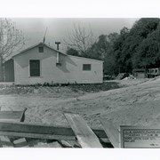
Clapboard house shown at the very edge of excavation work for flood control channel being constructed. There are rabbit hutches in area behind house. Exact location in Arcadia not known.
https://arcadiahistory.andornot.com/en/permalink/photographs820
- Date
- April 19, 1940
1 image
- Date
- April 19, 1940
- Subjects
- Flood control
- Physical Description
- 5x7 b&w
- ID
- 814
- Collection
- Photographs
Images

Despite recent heavy rains, water managers across the San Gabriel Valley still recommend that residents conserve water.
https://arcadiahistory.andornot.com/en/permalink/newspaper29387
- Newspaper
- Pasadena Star News
- Date
- January 17, 2005
- Pages
- p. A1
- Item ID
- 29571AN
- Collection
- Newspaper Index
- Contents
- 1. "Streams, washes, etc." Overlay to be used with the Thomas Brothers map book showing streams, washes, and drainage systems in Arcadia. Gift of Los Angeles County Flood Control, November 11, 1979.
- Contents
- 1. "Streams, washes, etc." Overlay to be used with the Thomas Brothers map book showing streams, washes, and drainage systems in Arcadia. Gift of Los Angeles County Flood Control, November 11, 1979.
- Subjects
- Flood Control
- Item ID
- 92AF
- Collection
- Subject Files
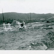
Flood damage on N. Santa Anita Avenue. A house is visible to the right and a person is standing with his/her back to the camera on the left. There are two sawhorses visible. The San Gabriel Mountains are seen in the background.
https://arcadiahistory.andornot.com/en/permalink/photographs1437
- Date
- March 1954
1 image
- Date
- March 1954
- Subjects
- Streets-Santa Anita Avenue
- Floods
- Physical Description
- 3x4
- ID
- 1424
- Collection
- Photographs
Images

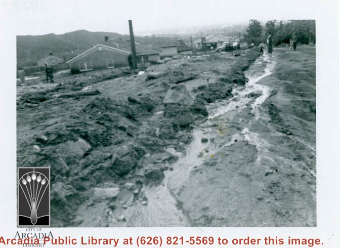
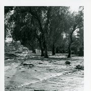
Flood damage on N. Santa Anita Avenue. A lot of mud and debris is visible. There are houses in the background and several people standing in the distance.
https://arcadiahistory.andornot.com/en/permalink/photographs1435
- Date
- March 1954
1 image
- Date
- March 1954
- Subjects
- Streets-Santa Anita Avenue
- Floods
- Physical Description
- 3x4
- ID
- 1422
- Collection
- Photographs
Images
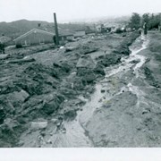
Flood damage on N. Santa Anita Avenue. A sign reads "FIRST BAPTIST CHURCH a MILE." There is an unidentified man walking toward the camera on the left.
https://arcadiahistory.andornot.com/en/permalink/photographs1439
- Date
- March 1954
1 image
- Date
- March 1954
- Subjects
- Streets-Santa Anita Avenue
- Floods
- Physical Description
- 3x4
- ID
- 1426
- Collection
- Photographs
Images

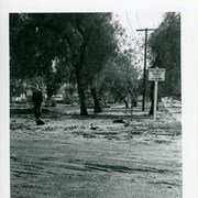
Flood damage on N. Santa Anita Avenue at Perkins Drive. Two or three people are seen walking in the distance.
https://arcadiahistory.andornot.com/en/permalink/photographs1436
- Date
- March 1954
1 image
- Date
- March 1954
- Subjects
- Streets-Santa Anita Avenue
- Floods
- Physical Description
- 3x4
- ID
- 1423
- Collection
- Photographs
Images
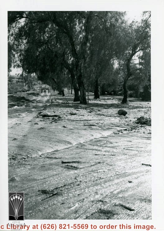
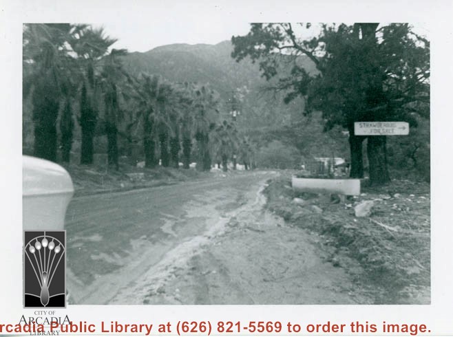
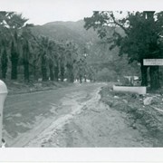
Flood damage on N. Santa Anita Avenue. The front end of a car is just visible in the left foreground. A sign nailed to a tree reads "STRAWBERRIES FOR SALE." The San Gabriel mountains are seen in the background.
https://arcadiahistory.andornot.com/en/permalink/photographs1438
- Date
- March 1954
1 image
- Date
- March 1954
- Subjects
- Streets-Santa Anita Avenue
- Floods
- Physical Description
- 3x4
- ID
- 1425
- Collection
- Photographs
Images
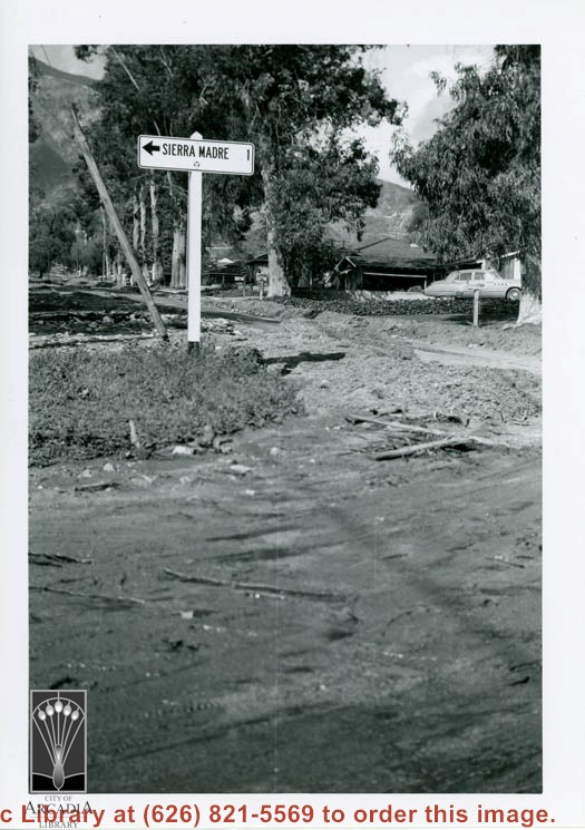
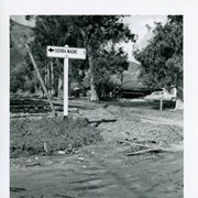
Flood damage on N. Santa Anita Avenue. This view was taken at Perkins and Santa Anita. A sign pointing toward Sierra Madre is visible on the left and the San Gabriel Mountains are visible in the background. There is a car on the right.
https://arcadiahistory.andornot.com/en/permalink/photographs1434
- Date
- March 1954
1 image
- Date
- March 1954
- Subjects
- Streets-Santa Anita Avenue
- Floods
- Physical Description
- 3x4
- ID
- 1421
- Collection
- Photographs
Images
General information on flood control channels in Arcadia.
https://arcadiahistory.andornot.com/en/permalink/newspaper4052
- Newspaper
- Arcadia Tribune
- Date
- June 28, 1935 p. 1 (Santa Anita Wash)
- February 11, 1936 p. 1 (Santa Anita Channel)
- September 12, 1936 p. 1 ( " )
- May 19, 1936 p. 1 (improvements by Los Angeles County proposed)
- July 15 [sic - should be July 17], 1936 p. 1
- July 19, 1936 p. 1 (study of Orange Grove, El Monte, Santa Anita Wash areas)
- August 4, 1936 p. 1 (El Monte)
- September 19, 1936 p. 1 ( " )
- September 24, 1936 p. 1 ( " )
- September 30, 1936 p. 1 ( " )
- October 13, 1936 p. 1 ( " )
- December 23, 1936 p. 1 (Arcadia-Sierra Madre control)
- April 6, 1938 p. 1 (relief fund sought)
- June 8, 1938 p. 1 (Santa Anita Wash)
- September 7, 1938 p. 1 (El Monte)
- September 17, 1938 p. 1 (Santa Anita Wash)
- September 22, 1938 p. 1 (Eaton Wash)
- September 27, 1938 p. 1 (report of suitable sites for control)
- October 4, 1938 p. 1 (Santa Anita Wash)
- August 24, 1939 p. 1 (Little Santa Anita creek control)
- July 17, 1941 p. 1 (canyon project)
- August 21, 1941 p. 1 (Santa Anita Canyon
- September 11, 1941 p. 1 (Santa Anita Wash)
- February 25, 1943 p. 1 (Snata Anita flood control)
- June 23, 1953 p. 1 (special project)
- November 19, 1953 p. 1 (Colorado Blvd. storm drain)
- December 24, 1953 p. 2 (action urged by Hillings)
- February 1, 1954 p. 1 (status in Arcadia as of January 1954)
- February 18, 1954 p. 1 (Federal action)
- February 25, 1954 p. 1 (basin)
- May 6, 1954 p. 1 (El Monte)
- July 1, 1954 p. 1 (wash maps)
- October 28, 1954 p. 1 (Flood Control District approves bridges over washes)
- November 8, 1954 p. 1 (State Dept. Water Resources approves bridges)
- November 11, 1954 p. 1 (protest denial of bridge for Sandra Ave.)
- November 15, 1954 p. 1 (Sandra to get bridge)
- November 18, 1954 p. 1 (Sandra bridge)
- December 9, 1954 p. 1 (Sandra bridge)
- February 7, 1955 p. 1 (Lanan Canyon pipe line)
- July 25, 1955 p. 1 ( Michillinda drain)
- October 6, 1955 p 1 (Michillinda drain)
- August 1, 1955 p. 1 (schedule plan)
- August 22, 1955 p. 1 ( " )
- November 3, 1955 p. 24 (Arcadia Wash improvement)
- June 7, 1956 p. 1 (map)
- March 7, 1957 p. 1 (Baldwin channel)
- May 6, 1957 p. 1 (Baldwin channel)
- September 1, 1958 p. 1 (County budget for Arcadia)
- March 23, 1959 p. 1 (Santa Anita Wash)
- July 30, 1959 p. 1 (Santa Anita Wash)
- September 26, 1968 p. 1 (Santa Anita Flood Control Committee)
- Subjects
- Flood Control
- Item ID
- 3928AN
- Collection
- Newspaper Index
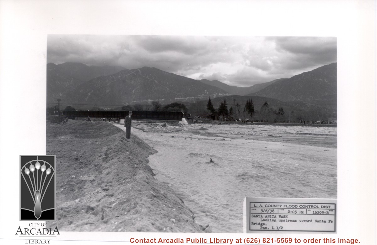
Looking directly north up flooded Santa Anita Wash. Santa Fe Railroad Bridge can be seen upstream. There is a man in a suit and hat standing at west edge of wash. This was following heavy rains of early March 1938.
https://arcadiahistory.andornot.com/en/permalink/photographs812
- Date
- March 6, 1938
1 image
- Date
- March 6, 1938
- Subjects
- Flood control
- Physical Description
- 5x7 b&w
- ID
- 806
- Collection
- Photographs
Images
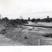
Looking downstream of Santa Anita Wash from east side of Santa Fe Bridge approach. In this photo the tracks and ties are seen completely suspended and a man is walking across the span. Two men are seen on extreme left side of photo.
https://arcadiahistory.andornot.com/en/permalink/photographs819
- Date
- March 6, 1938
1 image
- Date
- March 6, 1938
- Subjects
- Santa Anita Wash
- Flood control
- Physical Description
- 5x5 b&w
- ID
- 813
- Collection
- Photographs
Images

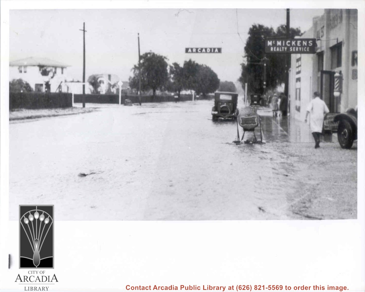
Looking east on Duarte near Baldwin intersection. McMickens Realty Service is located on right side of photo. There is a man walking on right dressed in white pharmacist's smock. There is heavy flooding evident on both streets. The Arcadia sign (welcome sign) is visible.
https://arcadiahistory.andornot.com/en/permalink/photographs597
- Date
- c. mid 1930's
1 image
- Date
- c. mid 1930's
- Subjects
- Duarte Road
- Flood control
- McMicken's Realty
- Physical Description
- 8x10 b&w
- ID
- 593
- Collection
- Photographs
Images
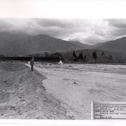
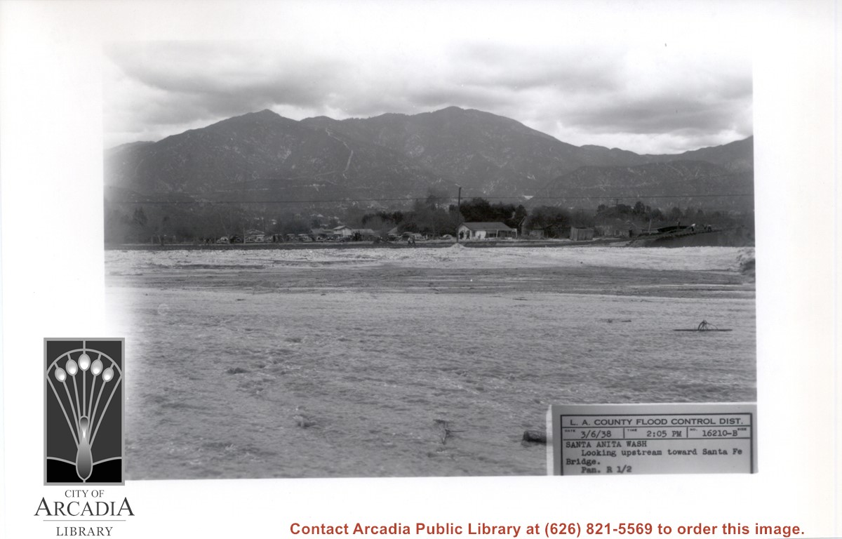
Looking NE up flooded Santa Anita Wash following heavy rains of early March 1938. Caption on photo reads: Looking upstream toward Santa Fe Bridge. San Gabriel Mountains in background. Where cars are parked would be east side of wash.
https://arcadiahistory.andornot.com/en/permalink/photographs811
- Date
- March 6, 1938
1 image
- Date
- March 6, 1938
- Subjects
- Flood control
- Physical Description
- 5x7 b&w
- ID
- 805
- Collection
- Photographs
Images
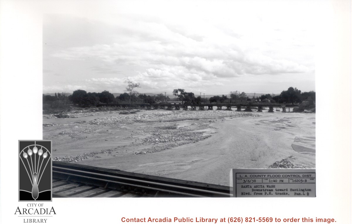
Looking south down stream of Santa Anita Wash. (Puente Hills can be seen in distance.) Caption of photo says picture was taken from PE Bridge and looking toward Huntington Drive Bridge.
https://arcadiahistory.andornot.com/en/permalink/photographs813
- Date
- March 6, 1938
1 image
- Date
- March 6, 1938
- Subjects
- Flood control
- Physical Description
- 5x7 b&w
- ID
- 807
- Collection
- Photographs
Images
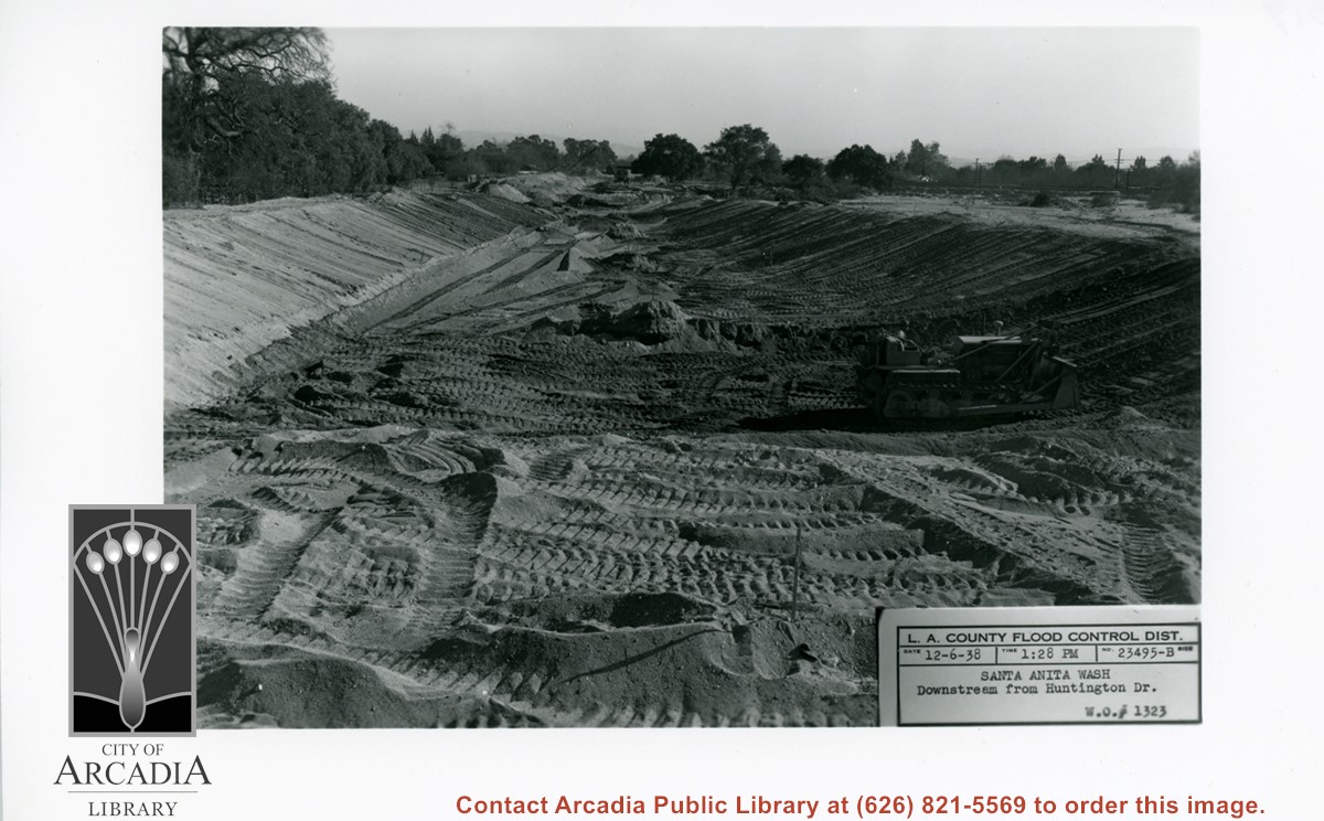
Looking south from Huntington Drive along Santa Anita Wash, following earth-moving preparatory to paving channel.
https://arcadiahistory.andornot.com/en/permalink/photographs823
- Date
- December 6, 1938
1 image
- Date
- December 6, 1938
- Subjects
- Santa Anita Wash
- Flood control
- Physical Description
- 5x7 b&w
- ID
- 817
- Collection
- Photographs
Images
Los Angeles County Arboretum. $8 million cleanup and restoration of Baldwin Lake sought. Flood control district assigns funding; expense to go before supervisors in July. Baldwin Lake is severely polluted centerpiece of the county Arboretum, visited by 400,000 people annually. The 144-year-old lake, dug out by 19th century real estate pioneer Elias Jackson “Lucky” Baldwin on his estate, has been dying a slow death because of the accumulation of street runoff laced with heavy metals, automobile brake fragments and other chemicals that create algae blooms and strong odors. Supervisor Kathryn Barger is championing the project.
https://arcadiahistory.andornot.com/en/permalink/newspaper35416
- Newspaper
- Pasadena Star News
- Date
- April 9, 2019
- Pages
- p. A1, A6
- Subjects
- Barger, Kathryn
- Los Angeles County Arboretum
- Los Angeles County Department of Public Works and Flood Control District
- Pestrella, Mark
- Item ID
- 35608AN
- Collection
- Newspaper Index