Skip header and navigation

20 records – page 1 of 1.

Forty acre Anoakia area annexation to Arcadia approved by the Local Agency Formation Commission.

https://arcadiahistory.andornot.com/en/permalink/newspaper397
Newspaper
Arcadia Tribune
Date
April 10, 1975
Pages
p. 1
Newspaper
Arcadia Tribune
Date
April 10, 1975
Pages
p. 1
Subjects
Annexation (Municipal Government)
Item ID
397AN
Collection
Newspaper Index
Less detail

The Arcadia City Council will oppose attempts by El Monte to annex a strip of uninhabited Arcadia land located between Peck Road and the San Gabriel River.

https://arcadiahistory.andornot.com/en/permalink/newspaper404
Newspaper
Arcadia Tribune
Date
August 24, 1978
Pages
p. 1
Newspaper
Arcadia Tribune
Date
August 24, 1978
Pages
p. 1
Subjects
Annexation (Municipal Government)
Item ID
404AN
Collection
Newspaper Index
Less detail

Proposed annexation of the area between Standish Street on the north and Jeffries on the south. One hundred percent of the residents of the area have asked to be annexed, so proceedings should move rapidly.

https://arcadiahistory.andornot.com/en/permalink/newspaper399
Newspaper
Arcadia Tribune
Date
June 8, 1975
Pages
p. 1
Newspaper
Arcadia Tribune
Date
June 8, 1975
Pages
p. 1
Subjects
Annexation (Municipal Government)
Item ID
399AN
Collection
Newspaper Index
Less detail

A meeting between the Arcadia and El Monte City Councils did not resolve the situation created by El Monte's attempts to annex 310 acres of Arcadia property south of Live Oak Avenue.

https://arcadiahistory.andornot.com/en/permalink/newspaper405
Newspaper
Arcadia Tribune
Date
November 16, 1978
Pages
p. A-1
Newspaper
Arcadia Tribune
Date
November 16, 1978
Pages
p. A-1
Subjects
Annexation (Municipal Government)
Item ID
405AN
Collection
Newspaper Index
Less detail

The El Monte City Council formally withdrew its petition to annex some 300 acres of Arcadia property south of Live Oak Avenue. Protests to the annexation represented more than 50% of the assessed property owners.

https://arcadiahistory.andornot.com/en/permalink/newspaper406
Newspaper
Arcadia Tribune
Date
November 26, 1978
Pages
p. A-1
Newspaper
Arcadia Tribune
Date
November 26, 1978
Pages
p. A-1
Subjects
Annexation (Municipal Government)
Item ID
406AN
Collection
Newspaper Index
Less detail

Annexation 80-2 proponents have taken first formal step toward annexation to Arcadia. Notice states boundaries of proposed annexation.

https://arcadiahistory.andornot.com/en/permalink/newspaper417
Newspaper
Arcadia Tribune
Date
August 22, 1982
Pages
p. 1
Newspaper
Arcadia Tribune
Date
August 22, 1982
Pages
p. 1
Subjects
Annexation (Municipal Government)
Item ID
417AN
Collection
Newspaper Index
Less detail

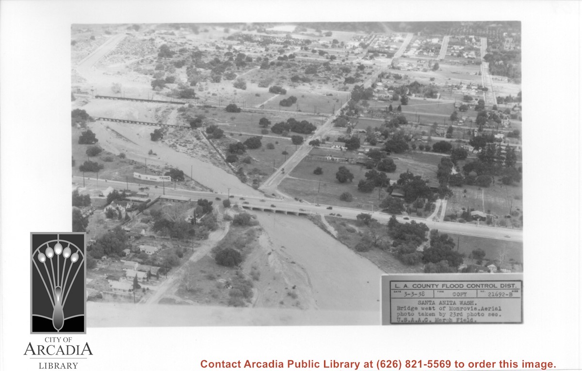
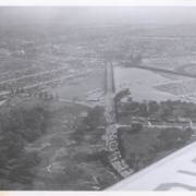
Aerial view looking north over flooded Santa Anita Wash looking upstream. Street cutting across photo closest to bottom is Huntington Drive. The next crossing upstream carries Santa Fe Railroad track. The last crossing that is clearly visible is Pacific Electric Railroad bridge. North/south street crossing Huntington Drive nearest wash would be Fifth Avenue. Foothill Boulevard is just barely visible near top of photo.

https://arcadiahistory.andornot.com/en/permalink/photographs815
Date
March 3, 1938

  1 image

Date
March 3, 1938
Subjects
Aerial Photo Collection
Aerial views
Fifth Avenue
Flood control
Foothill Boulevard
Huntington Drive
Railroads
Santa Anita Wash
Physical Description
5x7 b&w
ID
809
Collection
Photographs
Images
Less detail

There was standing room only at City Council meeting as the request for annexation by residents of an area west of the city was considered. The matter will be brought up again in July after Council has had time to investigate the ramifications.

https://arcadiahistory.andornot.com/en/permalink/newspaper409
Newspaper
Arcadia Tribune
Date
May 7, 1981
Pages
p. A-1
Newspaper
Arcadia Tribune
Date
May 7, 1981
Pages
p. A-1
Subjects
Annexation (Municipal Government)
Item ID
409AN
Collection
Newspaper Index
Less detail

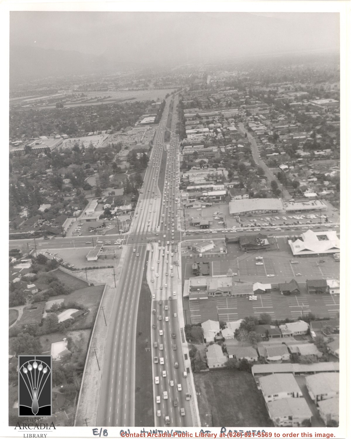
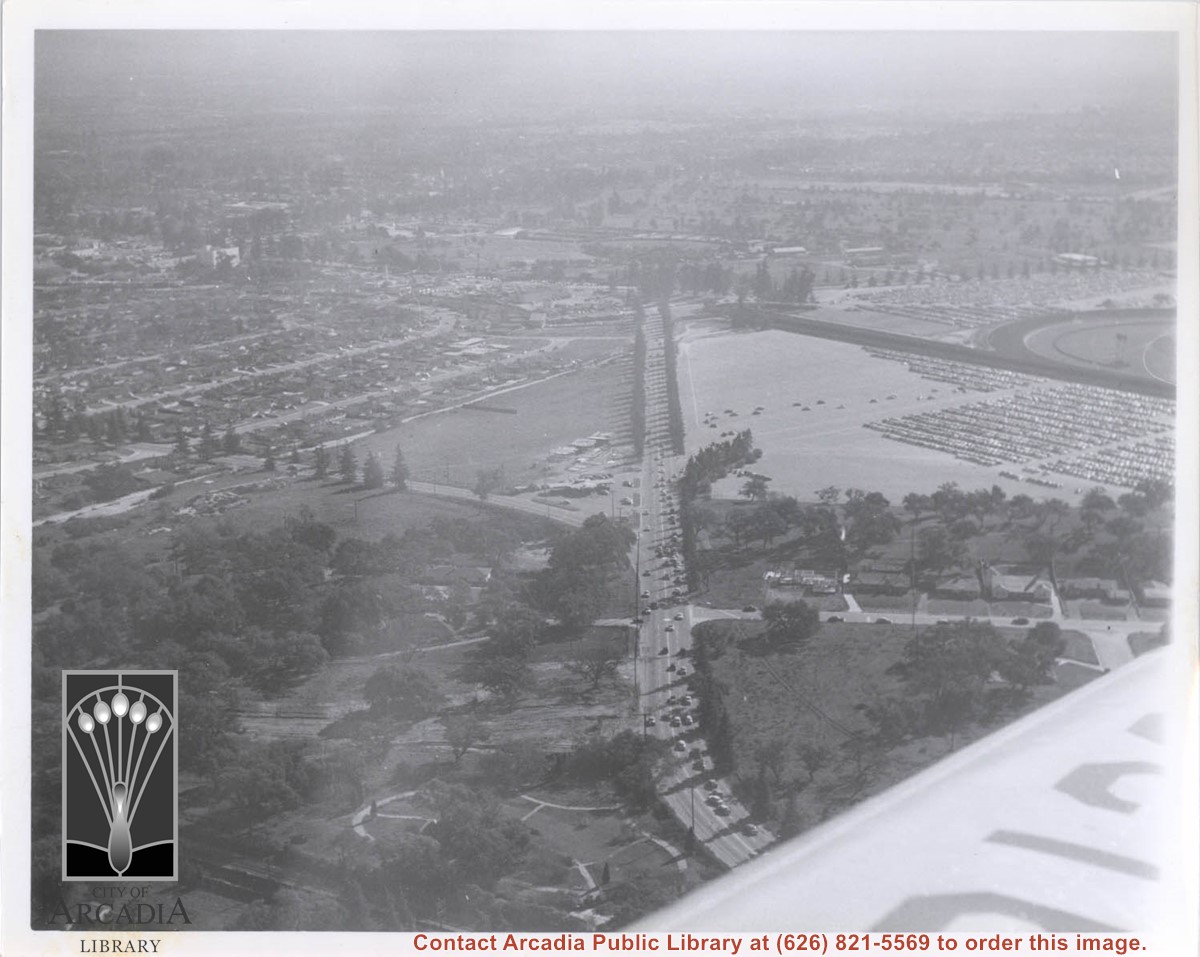
Aerial view east on Huntington Drive toward Arcadia from a position just west of Rosemead Boulevard. El Rancho Shopping Center and May Company Department Store can be seen as the business complex on the north side of Huntington Drive one block east of Rosemead Boulevard. Santa Anita Park Race Track can be seen on the left in upper portion of photo.

https://arcadiahistory.andornot.com/en/permalink/photographs637
Date
c.1970

  1 image

Temple City will not try to annex an unincorporated area near Arcadia, bounded by Daines Drive on the north, Tyler Avenue on the east, West Hondo Parkway on the south and Santa Anita Avenue on the west. Temple City will continue efforts to expand the city's north and south boundaries but wanted to avoid a fight with Arcadia for this area.

https://arcadiahistory.andornot.com/en/permalink/newspaper30103
Newspaper
Pasadena Star News
Date
June 22, 2006
Pages
p. A3
Newspaper
Pasadena Star News
Date
June 22, 2006
Pages
p. A3
Subjects
Annexation
Temple City
Unincorporated areas - Los Angeles County
Item ID
30290AN
Collection
Newspaper Index
Less detail

A house-to-house survey of registered voters in Annexation Area 80-2 shows that most of the voters favor annexation by Arcadia over Temple City. Article gives the breakdown by street. The area is an "island" bounded by Temple City Blvd. on the west, Longden Ave. on the south, and the Arcadia boundary on the north and east.

https://arcadiahistory.andornot.com/en/permalink/newspaper415
Newspaper
Arcadia Tribune
Date
July 25, 1982
Pages
p. A-1
Newspaper
Arcadia Tribune
Date
July 25, 1982
Pages
p. A-1
Subjects
Annexation (Municipal Government)
Item ID
415AN
Collection
Newspaper Index
Less detail

Residents of the 80-2 Homeowners Association are regrouping in their efforts to have their 84+ acre area south and west of the city annexed. Issues involved are discussed.

https://arcadiahistory.andornot.com/en/permalink/newspaper411
Newspaper
Arcadia Tribune
Date
January 17, 1982
Pages
p. A-1
Newspaper
Arcadia Tribune
Date
January 17, 1982
Pages
p. A-1
Subjects
Annexation (Municipal Government)
Item ID
411AN
Collection
Newspaper Index
Less detail

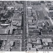
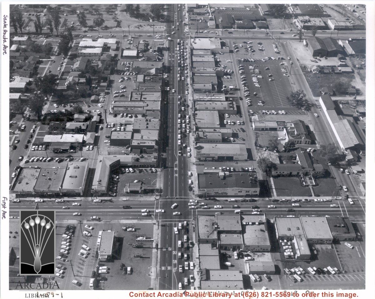
Aerial view from above Huntington Drive between Santa Anita Avenue and First Avenue. Huntington Drive intersects the photo from north to south. The street closest to the bottom is First Avenue and Santa Anita Avenue is near the top.

https://arcadiahistory.andornot.com/en/permalink/photographs1403
Date
c.1959

  1 image

Date
c.1959
Subjects
Aerial Photo Collection
Aerial views
First Avenue
Huntington Drive
Santa Anita Avenue
Physical Description
8x10 b&w
ID
1390
Collection
Photographs
Images
Less detail

The City Council on May 6 passed a resolution as required by law consenting to the annexation of the Anoakia area. They also passed a second resolution requesting the Board of Supervisors to hold off on any general plans or zone change hearings until after the annexation election is held.

https://arcadiahistory.andornot.com/en/permalink/newspaper398
Newspaper
Arcadia Tribune
Date
May 8, 1975
Pages
p. 1
Newspaper
Arcadia Tribune
Date
May 8, 1975
Pages
p. 1
Subjects
Annexation (Municipal Government)
Item ID
398AN
Collection
Newspaper Index
Less detail

County Area west of City limits to Rosemead - known as West Arcadia annex #40.

https://arcadiahistory.andornot.com/en/permalink/newspaper3699
Newspaper
Arcadia Tribune
Date
February 2, 1967 p. 1
February 16, 1967 p. 1
February 23, 1967 p. 1
March 12, 1967 p. 1
March 16,1967 p. 1
March 19, 1967 p. 1
April 9, 1967 p. 1
April 13, 1967 p. 1
April 23, 1967 p. 1
May 4, 1967 p. 1
May 7, 1967 p. 1
May 14, 1967 p. 1
May 18, 1967 p. 1
June 11, 1967 p. 1
June 25, 1967 p. 1
July 20, 1967 p. 1
September 28, 1967 p. 1
October 1, 1967 p. 1
January 18, 1968 p. 1
January 21, 1968 p. 1
January 25, 1968 p. 1
February 8 1968 p. 1
March 17, 1968 p. 1
March 21, 1968 p. 1
March 28, 1968 p. 1 (protests)
April 18, 1968 p. 1 (defeated)
Subjects
Annexation (Municipal Government)
Item ID
3574AN
Collection
Newspaper Index
Less detail

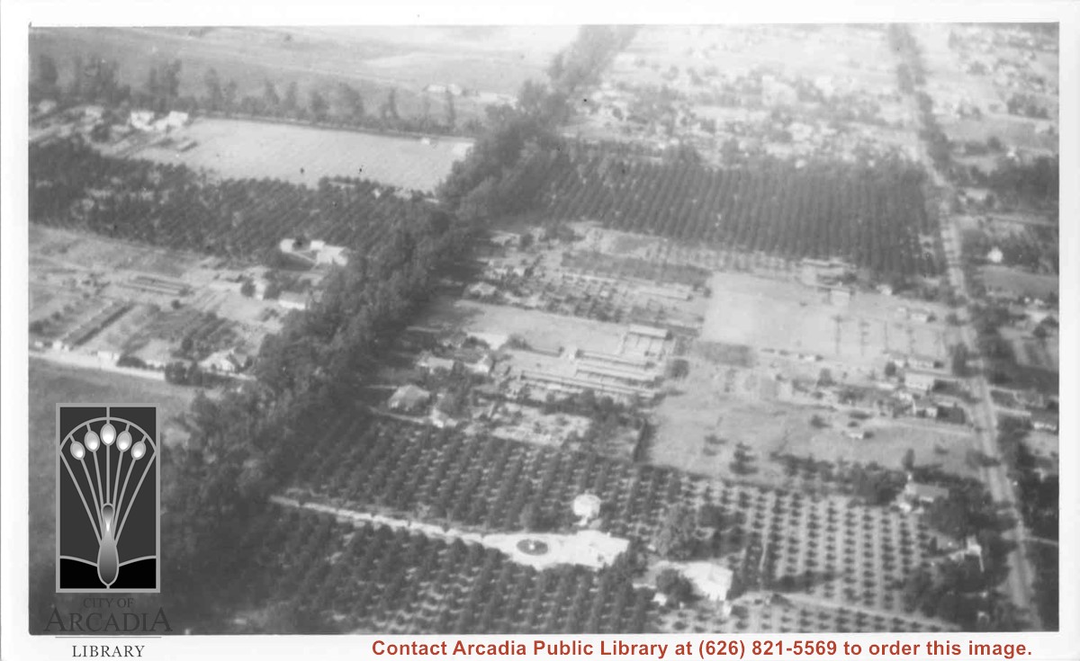
Aerial view north. Main tree-lined street is Santa Anita Avenue. Most of the orange grove in center of photo was owned by Jaspar Teague family. They had built a circular art gallery on their property at 1380 South Santa Anita Avenue. The large buildings north of Teague's and to the west of Santa Anita Avenue are chicken houses. Duarte Road is the east/west street across photo near top of photo.

https://arcadiahistory.andornot.com/en/permalink/photographs645
Date
November 1929

  1 image

Date
November 1929
Subjects
Aerial Photo Collection
Aerial views
Agriculture
Duarte Road
Orange groves
Poultry
Santa Anita Avenue
Teague, Jaspar
Physical Description
6x10 b&w
ID
641
Collection
Photographs
Images
Less detail

Aerial view south on Colorado Street just over large turn to the west. The residential area known as Santa Anita Gardens shows along upper left section of photo. Note that the only commerical development along the north side of Colorado Street is the Westerner Motel just near intersection with Huntington Drive. Santa Fe Railroad tracks are seen in lower left corner of photo. Santa Anita Park Race Track is on right.

https://arcadiahistory.andornot.com/en/permalink/photographs641
Date
c. 1956

  1 image

Annexation (Municipal Government)

https://arcadiahistory.andornot.com/en/permalink/subject7
Contents
1. City of Arcadia Annexation No. 33 (Map, West Arcadia, 1964) 2. City of Arcadia Annexation No. 35 (Map, West Arcadia, November 16,1964) 3. City of Arcadia Annexation No. 36 (Map, Southeast Arcadia, 1965) 4. City of Arcadia Annexation No. 37 (Map, West Arcadia, 1965) 5. City of Arcadia Annexa…
Contents
1. City of Arcadia Annexation No. 33 (Map, West Arcadia, 1964)
2. City of Arcadia Annexation No. 35 (Map, West Arcadia, November 16,1964)
3. City of Arcadia Annexation No. 36 (Map, Southeast Arcadia, 1965)
4. City of Arcadia Annexation No. 37 (Map, West Arcadia, 1965)
5. City of Arcadia Annexation No. 38 (Map, West Arcadia, 1968)
6. City of Arcadia Annexation No. 46 (Map, Michillinda and Huntington Drive, August 1977)
7. "Land: Arcadia has it, El Monte wants it." News clip, November 9, 1978.
8. "Annexation problem not yet solved." News clip, November 16, 1978.
Subjects
Annexation (Municipal Government)
Item ID
7AF
Collection
Subject Files
Less detail

Aerial view toward NE. Plane is over property of Charles W. Stewart (10 acres), and Jaspar Teague (10 acres), at 1320 S. Santa Anita Avenue, which is directly under the plane. Next street east is First Avenue, then Second Avenue, the Fourth Avenue. Reservoir is at corner of Valnett Avenue and Second Avenue and was owned by Walnut Grove Mutual Water Company (Valnett Avenue was first through street south of Duarte Road at this time and became Camino Real).

https://arcadiahistory.andornot.com/en/permalink/photographs644
Date
November 1929

  1 image

Anoakia property annexation papers drawn up. The City Council has instructed its staff to file an annexation application and environmental impact report. It would be in essence a re-annexation, as the area was once part of the city and was de-annexed in 1904. The proposed area also encompasses 16 single family homes.

https://arcadiahistory.andornot.com/en/permalink/newspaper395
Newspaper
Arcadia Tribune
Date
January 23, 1975
Pages
p. 1
Newspaper
Arcadia Tribune
Date
January 23, 1975
Pages
p. 1
Subjects
Annexation (Municipal Government)
Item ID
395AN
Collection
Newspaper Index
Less detail

20 records – page 1 of 1.