Skip header and navigation

20 records – page 1 of 1.

Santa Anita Canyon Road, aka Chantry Flat Road, has been jointly owned by Arcadia, Sierra Madre, Monrovia, and Los Angeles County for years. The 3-mile mountain road that leads to the Angeles National Forest will be turned over to Los Angeles County if the cities pay to fix it up. Arcadia and Sierra Madre have completed their repairs and are waiting for Monrovia to start a roughly $500,000 project.

https://arcadiahistory.andornot.com/en/permalink/newspaper31867
Newspaper
Pasadena Star News
Date
January 18, 2010
Pages
p. A3
Newspaper
Pasadena Star News
Date
January 18, 2010
Pages
p. A3
Subjects
Chantry Flat Road
Santa Anita Canyon Road
Item ID
32064AN
Collection
Newspaper Index
Less detail

Six years ago after severe winter rains, Cal FEMA gave several grants to cities responsible for the maintenance of the road to Chantry Flats north into the foothills from Arcadia. Monrovia is responsible for a small segment of that road, but it has not yet been repaired. Monrovia City Manager Scott Ochoa explained that the initial grant was insufficient to pay for the repairs.

https://arcadiahistory.andornot.com/en/permalink/newspaper32565
Newspaper
Arcadia Weekly
Date
September 29, 2011
Pages
p. 1, 11
Newspaper
Arcadia Weekly
Date
September 29, 2011
Pages
p. 1, 11
Subjects
Chantry Flats
Monrovia
Ochoa, Scott
Roads
Item ID
32764AN
Collection
Newspaper Index
Less detail

This month's heavy rainstorms triggered as many as 18 mudslides. The first major slide deposited 6000 cubic yards of mud on a section of road in Arcadia. The road to Chantry Flat is closed until further notice.

https://arcadiahistory.andornot.com/en/permalink/newspaper29393
Newspaper
Pasadena Star News
Date
January 29, 2005
Pages
p. A1
Newspaper
Pasadena Star News
Date
January 29, 2005
Pages
p. A1
Subjects
Chantry Flat
Santa Anita Canyon Road
Mudslides
Rain damages
Item ID
29577AN
Collection
Newspaper Index
Less detail

Chantry Flat Road, also known as Santa Anita Canyon Road, will reopen to the public on Wednesday, April 16, despite unfinished repairs. Fire in the Santa Anita Canyon had forced a 6-month closure of the road.

https://arcadiahistory.andornot.com/en/permalink/newspaper31236
Newspaper
Arcadia Weekly
Date
April 17, 2003
Pages
p. 19
Newspaper
Arcadia Weekly
Date
April 17, 2003
Pages
p. 19
Subjects
Chantry Flat Road
Santa Anita Canyon Road
United States Forest Service
Item ID
31429AN
Collection
Newspaper Index
Less detail

Workers use earth-moving equipment to shore up Chantry Flat Road, which has been closed for over a year due to mudslides. The road may re-open at the end of September.

https://arcadiahistory.andornot.com/en/permalink/newspaper29578
Newspaper
Pasadena Star News
Date
July 9, 2005
Pages
p. A1
Newspaper
Pasadena Star News
Date
July 9, 2005
Pages
p. A1
Subjects
Chantry Flat
Santa Anita Canyon Road
Road repairs
Angeles National Forest
Item ID
29762AN
Collection
Newspaper Index
Less detail

Kim Kelley, owner of the Adams pack station near Chantry Flat, has decided to sell the historic station for financial reasons. The heavily damaged roads to Big Santa Anita Canyon have hurt her business.

https://arcadiahistory.andornot.com/en/permalink/newspaper29791
Newspaper
Pasadena Star News
Date
November 25, 2005
Pages
p. A1, A8
Newspaper
Pasadena Star News
Date
November 25, 2005
Pages
p. A1, A8
Subjects
Adams Station
Big Santa Anita Canyon
Chantry Flat
Kelley, Kim
Pack stations
Item ID
29976AN
Collection
Newspaper Index
Less detail

Chantry Flat is still closed as a public area gets reconstructed and Arcadia's Public Works Department handles other road improvements.

https://arcadiahistory.andornot.com/en/permalink/newspaper29337
Newspaper
Pasadena Star News
Date
December 20, 2004
Pages
p. A1
Newspaper
Pasadena Star News
Date
December 20, 2004
Pages
p. A1
Subjects
Chantry Flat
Closures
Angeles National Forest
Roadwork
Item ID
29521AN
Collection
Newspaper Index
Less detail

A cabin is lost, but memories endure. Greg Vanni of Arcadia, had a cabin among the 80 historic Chantry Flat cabins in Big Santa Anita Canyon. It burned to its foundation in the Bobcat Fire. It was a 350-foot cabin built in 1910 during "The Great Hiking Era," a time between the 1880s to the late 1930s in Southern California, when settlers from the city were drawn to the San Gabriel Mountains looking for adventure. The historic Adams Pack Station survived the fire.

https://arcadiahistory.andornot.com/en/permalink/newspaper35859
Newspaper
Pasadena Star News
Date
November 22, 2020
Pages
p. A4, A5
Newspaper
Pasadena Star News
Date
November 22, 2020
Pages
p. A4, A5
Subjects
Big Santa Anita Canyon
Bobcat Fire
Cabins
Chantry Flat
Fires
Schoth, Lauren
Vanni, Greg
Collection
Newspaper Index
Less detail

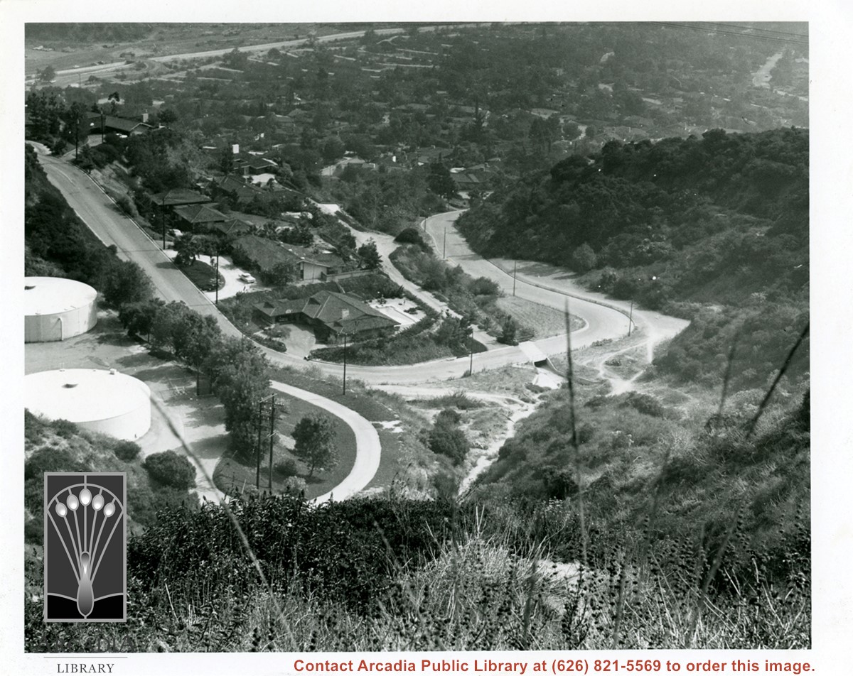
View from Chantry Flats Road down onto Canyon Road curving in the Upper Highlands, a residential area in north Arcadia. Santa Anita wash and the spreading basins are seen in extreme upper left in photo.

https://arcadiahistory.andornot.com/en/permalink/photographs1076
Date
c.1976

  1 image

Date
c.1976
Subjects
Canyon Road
Physical Description
6x7 b&w
ID
1067
Collection
Photographs
Images
Less detail

The road to Chantry Flat will close April 1 for repairs, with Arcadia and Los Angeles County working to fix two sections of the road. Closure will last until July 9.

https://arcadiahistory.andornot.com/en/permalink/newspaper27843
Newspaper
Pasadena Star News
Date
March 12, 2004
Pages
p. A3
Newspaper
Pasadena Star News
Date
March 12, 2004
Pages
p. A3
Subjects
Chantry Flat
Item ID
28040AN
Collection
Newspaper Index
Less detail

Seven months after Chantry Flat Road was closed at night, the noise that bothered residents and the injuries from auto accidents have virtually ceased.

https://arcadiahistory.andornot.com/en/permalink/newspaper3391
Newspaper
Arcadia Tribune
Date
December 23, 1987
Pages
p. A-1
Newspaper
Arcadia Tribune
Date
December 23, 1987
Pages
p. A-1
Subjects
Streets - Chantry Flat Road
Item ID
3281AN
Collection
Newspaper Index
Less detail

Aerial view north up Santa Anita Avenue. Note Chantry Flats Road on mountain near right side of photo. This view was taken from just south of Huntington Drive. This image belongs to Arcadia Historical Society.

https://arcadiahistory.andornot.com/en/permalink/photographs587
Date
November 1926

  1 image

Date
November 1926
Subjects
Aerial Photo Collection
Aerial views
Chantry Flats Road
Santa Anita Avenue
Physical Description
6x10 vertical
ID
583
Collection
Photographs
Images
Less detail

Arcadia Public Works crews worked to divert mud resulting from recent heavy rains in the Santa Anita Fire area.

https://arcadiahistory.andornot.com/en/permalink/newspaper18619
Newspaper
Los Angeles Times San Gabriel Valley Weekly Section
Date
February 25, 2000
Pages
p. 1 w/photo
Newspaper
Los Angeles Times San Gabriel Valley Weekly Section
Date
February 25, 2000
Pages
p. 1 w/photo
Subjects
Santa Anita Fire
Item ID
18863AN
Collection
Newspaper Index
Less detail

Damage saps fun from Angeles forest. Angeles National Forest's Chantry Flat Road remains closed after suffering damage from the 2020 Bobcat fire and subsequent fires. Storms and fires force closure of trails, roads and campgrounds, some for years. The forest's second-most visited area, Chantry Flat, in the section north of Arcadia, Monrovia and Sierra Madre, has been closed since the start of the pandemic in March 2020. A sign in Arcadia (photo) advises motorists of the Chantry Flat Road closure.

https://arcadiahistory.andornot.com/en/permalink/newspaper36507
Newspaper
Pasadena Star News
Date
July 18, 2023
Pages
p. A1, A6
Newspaper
Pasadena Star News
Date
July 18, 2023
Pages
p. A1, A6
Subjects
Angeles National Forest
Bobcat Fire
Chantry Flat
Collection
Newspaper Index
Less detail

Chantry Flat and other areas of the Angeles National Forest have been closed to the public due to extreme fire conditions.

https://arcadiahistory.andornot.com/en/permalink/newspaper29146
Newspaper
Pasadena Star News
Date
September 25, 2004
Pages
p. A1
Newspaper
Pasadena Star News
Date
September 25, 2004
Pages
p. A1
Subjects
Angeles National Forest
Closures
Chantry Flat
Item ID
29331AN
Collection
Newspaper Index
Less detail

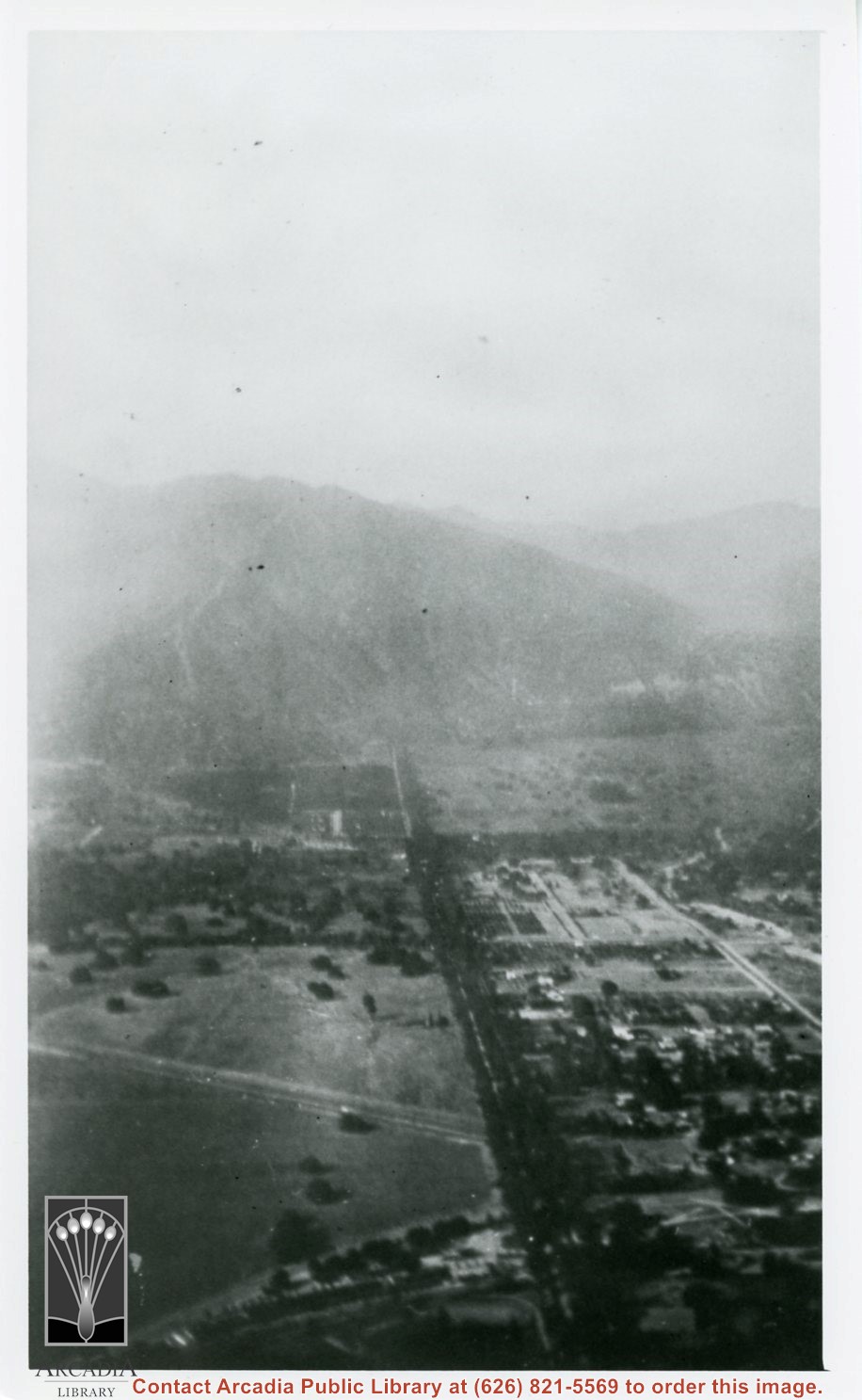
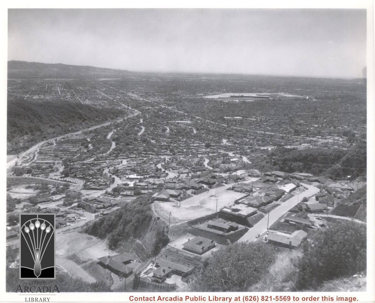
Aerial view south from Chantry Flats Road over the still-developing upper Highlands section of Arcadia. View is across Arcadia toward the Puente Hills. Santa Anita Park Race Track is seen in the center. Santa Anita Wash is seen on extreme left.

https://arcadiahistory.andornot.com/en/permalink/photographs955
Date
c.1965

  1 image

Date
c.1965
Subjects
Aerial Photo Collection
Aerial views
Arcadia(City)-History-1960-1969
Chantry Flats Road
Santa Anita Wash
Physical Description
8x10 b&w
ID
949
Collection
Photographs
Images
Less detail

Bobcat Fire - Most Chantry Flat cabins survived - 62 of 80 structures, historic Adams Pack Station did not burn down in massive Bobcat Fire which broke out September 6.

https://arcadiahistory.andornot.com/en/permalink/newspaper35860
Newspaper
Pasadena Star News
Date
November 22, 2020
Pages
p. A1, A5
Newspaper
Pasadena Star News
Date
November 22, 2020
Pages
p. A1, A5
Subjects
Angeles National Forest
Big Santa Anita Canyon
Bobcat Fire
Fires
Vanni, Greg
Collection
Newspaper Index
Less detail

Money from a $19.9 billion statewide transportation bond approved by voters in 2006 is being used for road improvement projects. Arcadia received $900,000 for the rehabilitation of Santa Anita Avenue, which is already under construction. Two photographs of Santa Anita Avenue with captions are included.

https://arcadiahistory.andornot.com/en/permalink/newspaper31202
Newspaper
Pasadena Star News
Date
September 10, 2008
Pages
p. A1, A8
Newspaper
Pasadena Star News
Date
September 10, 2008
Pages
p. A1, A8
Subjects
Road construction - Santa Anita Avenue
Transportation bond
Item ID
31397AN
Collection
Newspaper Index
Less detail

Despite recent heavy rains, water managers across the San Gabriel Valley still recommend that residents conserve water.

https://arcadiahistory.andornot.com/en/permalink/newspaper29387
Newspaper
Pasadena Star News
Date
January 17, 2005
Pages
p. A1
Newspaper
Pasadena Star News
Date
January 17, 2005
Pages
p. A1
Subjects
Santa Anita Dam
Storms
Floods
Drinking water supply
Conservation
Item ID
29571AN
Collection
Newspaper Index
Less detail

View across Arcadia taken from Chantry Flats Road at night. Long diagonal streak starting near bottom of lower right, marks Santa Anita Avenue.

https://arcadiahistory.andornot.com/en/permalink/photographs1159
Date
c.1952

  1 image

Date
c.1952
Subjects
Aerial Photo Collection
Aerial views
Arcadia(City)-History-1950-1959
Chantry Flats Road
Physical Description
5x10 b&w
ID
1150
Collection
Photographs
Images
Less detail

20 records – page 1 of 1.