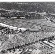
Aerial view taken over Arcadia so that it shows a large area surrounding Arcadia as well as the entire city. Clearly seen is the Santa Anita Park Race Track, and the Arcadia County Park (shown as a dark triangle in center), and the 210 Foothill Freeway crossing photo from west to east and passing north of Santa Anita Park Race Track.
Aerial view looking north across Santa Anita Park from a position over Arcadia County Park. Large infield crowd is evident and all parking areas are filled. Arcadia Methodist Hospital shows in lower left part of photo and Arcadia Police facility is seen in lower right. The 210 Foothill Freeway cuts across photo near the top.
Aerial view looking east across Santa Anita Park taken from a position just west of Baldwin Avenue, which is seen at bottom of photo. Huntington Drive appears exactly in center of photo just east of race track. The 210 Foothill Freeway enters area in upper right portion of picture and exits at left side in upper left portion.
Aerial view toward north from a position south of Huntington Drive near intersection with Baldwin Avenue. It shows Santa Anita Fashion Park (currently known as Westfield Santa Anita Shopping Mall) developed by and on property owned by Santa Anita Consolidated. The Santa Anita Park Race Track and club house can be seen in center of photo. The straight white line about one inch above the club house roof is 210 Foothill Freeway. Chantry Flats road can be seen going up into San Gabriel Mountains in distance.
Los Angeles County keeps environmental activists and media off the site where the 11 acres of oak tree woodlands are being bulldozed near Wilderness Park. It is called Santa Anita Dam Sediment Placement Site. Activists were unable to save the area from becoming a debris basin. See related story "Razing woodland: protesters watch as trees are cut down" Pasadena Star News, January 13, 2011, p. A1, A7.
Los Angeles County supervisor Mike Antonovich plans to set aside $650,000 of county funds to re-seed the oak woodland habitat in Arcadia that was demolished last week for flood control purposes, after mud and debris dredged from the Santa Anita Dam has been spread at the site. Bob Spencer, spokesman for Los Angeles County Department of Public Works, said there is much more debris poised to come down the hills and "We need to find a solution." Other county wilderness areas face destruction to make way for sediment. Officials are already considering the relocation of sediment from Devil's Gate Dam, which could end up on a 40-acre mature black willow woodland in the Hahamongna Watershed Park. Environmental activists won't let that happen without a fight.