View across Arcadia taken from Chantry Flats Road at night. Long diagonal streak starting near bottom of lower right, marks Santa Anita Avenue.
https://arcadiahistory.andornot.com/en/permalink/photographs1159
- Date
- c.1952
1 image


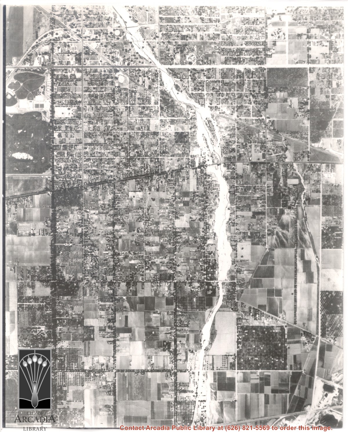
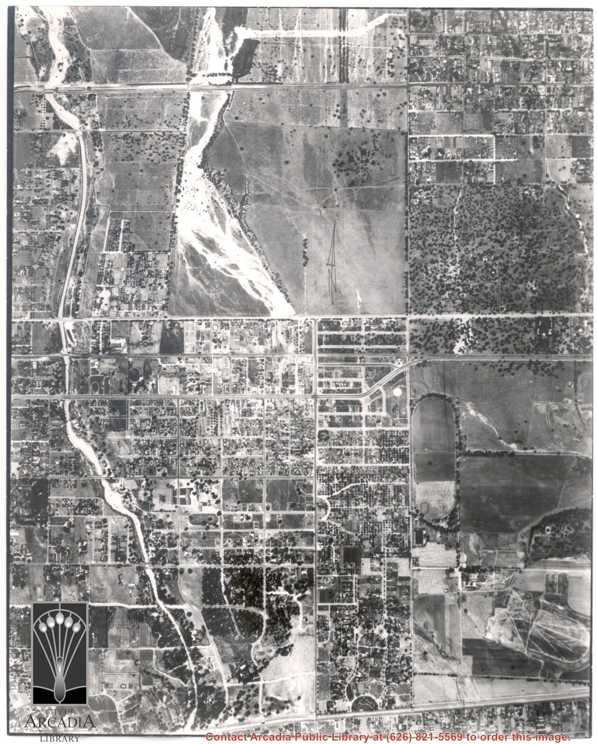
Most prominent physical feature is Santa Anita Wash running north to south almost in center of photo, just above center(?). Santa Anita Avenue is north/south street, dark with trees approximately one inch from left edge of photo. Arcadia County Park is at upper left edge of photo with baseball diamond showing.
https://arcadiahistory.andornot.com/en/permalink/photographs622
- Date
- June 5, 1938
1 image
- Date
- June 5, 1938
- Subjects
- Aerial Photo Collection
- Aerial views
- Arcadia County Park
- Duarte Road
- Santa Anita Avenue
- Santa Anita Wash
- Physical Description
- 8x10 b&w
- ID
- 618
- Collection
- Photographs
Images
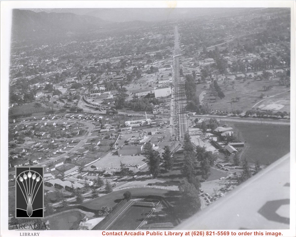
Aerial view looking east along Huntington Drive taken over the Club House at Santa Anita Park Race Track. Pony Express Museum is just to right of the "y" intersection of Huntington Drive coming into Arcadia just below the wing of the plane. Theater that was opened in 1942 is almost directly opposite Museum. Santa Anita Motor Inn, two buildings east of theater, distinguished by tall tower, opened in 1938. (It was torn down in 1975.) The residential area directly north of there is known as Santa Anita Gardens. Santa Anita Avenue is just beyond Arcadia County Park on right.
https://arcadiahistory.andornot.com/en/permalink/photographs642
- Date
- c. 1957-58
1 image
- Date
- c. 1957-58
- Subjects
- Aerial Photo Collection
- Aerial views
- Huntington Drive
- Pony Express Museum
- Santa Anita Avenue
- Santa Anita Motor Inn
- Physical Description
- 8x10 b&w
- ID
- 638
- Collection
- Photographs
Images
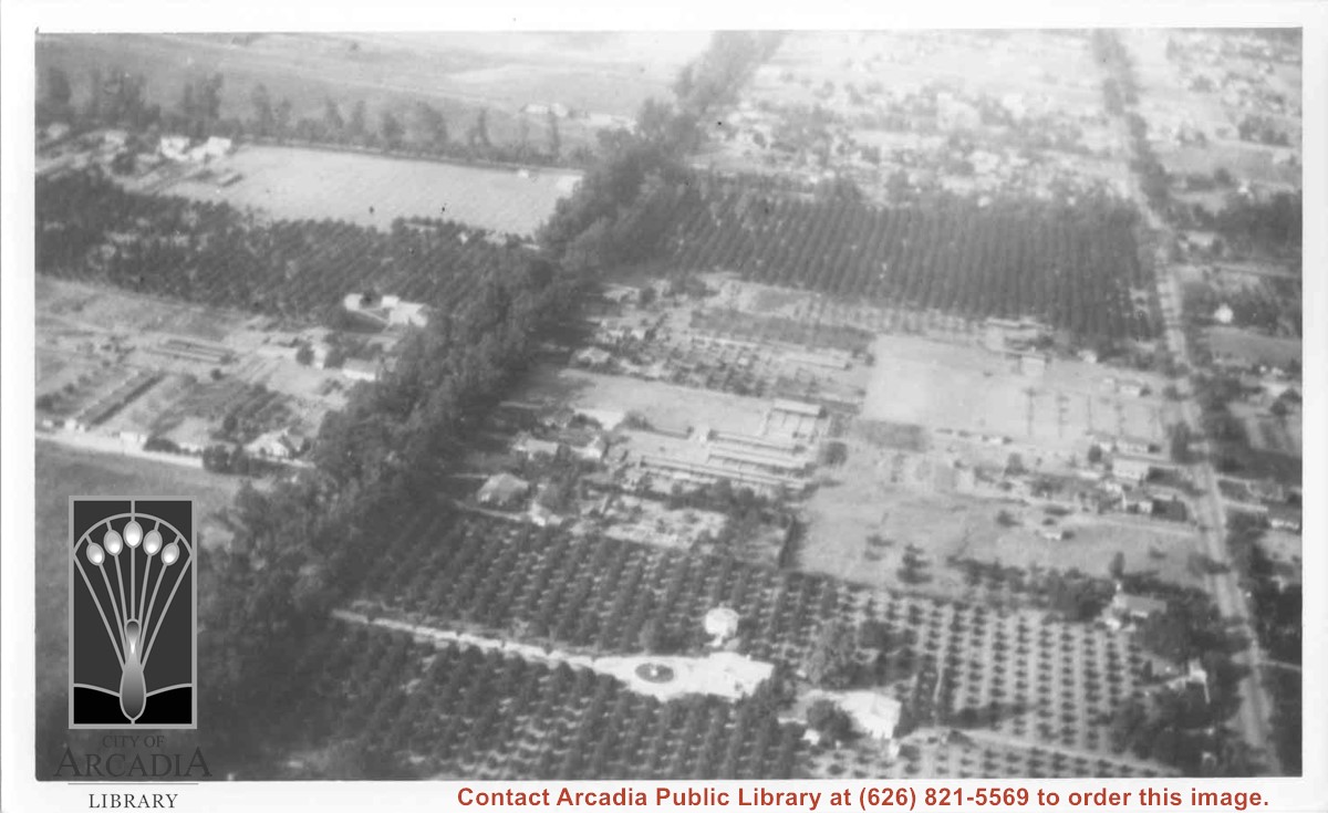
Aerial view north. Main tree-lined street is Santa Anita Avenue. Most of the orange grove in center of photo was owned by Jaspar Teague family. They had built a circular art gallery on their property at 1380 South Santa Anita Avenue. The large buildings north of Teague's and to the west of Santa Anita Avenue are chicken houses. Duarte Road is the east/west street across photo near top of photo.
https://arcadiahistory.andornot.com/en/permalink/photographs645
- Date
- November 1929
1 image
- Date
- November 1929
- Subjects
- Aerial Photo Collection
- Aerial views
- Agriculture
- Duarte Road
- Orange groves
- Poultry
- Santa Anita Avenue
- Teague, Jaspar
- Physical Description
- 6x10 b&w
- ID
- 641
- Collection
- Photographs
Images
Main north/south running street to right of center is Michillinda Avenue. Oval adjacent to Michillinda Avenue is Elias J. "Lucky" Baldwin's training track. Lower right corner of photo is abandoned project of Anita Baldwin and Joe Smoot, c. 1933 (about where May Company was and where Vons, a Safeway Company, Southern California Division Headquarters is now, at 618 Michillinda Avenue). Street running east/west across center of photo is present day Colorado Boulevard. East/west-running street near top of photo is present Foothill Boulevard. Wash along left side of photo is Eaton Wash, Pasadena. Scale: 1 inch=660 feet.
https://arcadiahistory.andornot.com/en/permalink/photographs623
- Date
- June 5, 1938
1 image
- Date
- June 5, 1938
- Subjects
- Aerial Photo Collection
- Aerial views
- Eaton Wash
- Foothill Boulevard
- Los Angeles Jockey Club
- Michillinda Avenue
- Physical Description
- 8x10 b&w
- ID
- 619
- Collection
- Photographs
Images
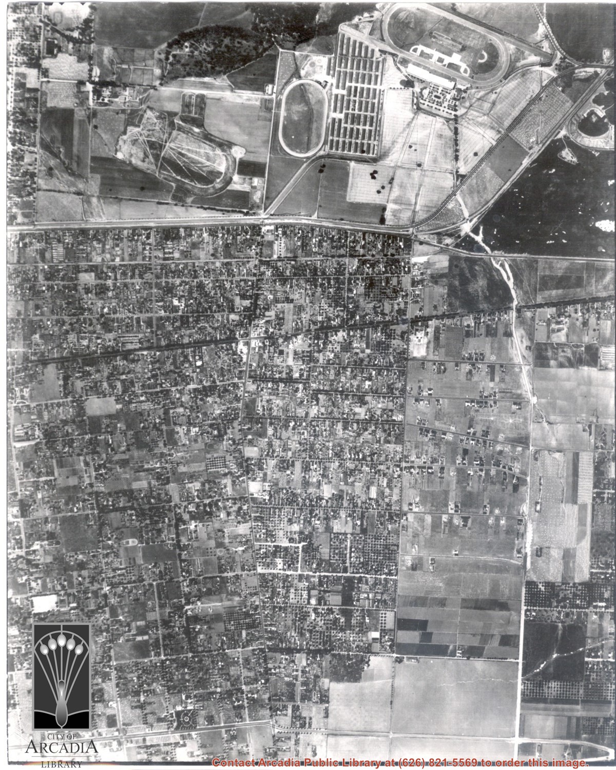
Dark, tree-lined street completely bisecting photo from west to east just above, is Duarte Road. Santa Anita Park Race Track is at upper right edge of photo. Smaller oval nearby is a training track. The incomplete oval in upper left is the race track that Anita Baldwin and Joe Smoot attempted to build in 1933 but abandoned the project. Huntington Drive and Colorado Place form a "y" just east of Santa Anita Park Race Track. Note grove of olive trees on land where City Hall is located today (240 W. Huntington Drive, Arcadia). Baseball diamond in upper right corner of photo, just below the convergence of the "y" is at Arcadia County Park. Corrected description as of 11/04/2008.
https://arcadiahistory.andornot.com/en/permalink/photographs621
- Date
- June 5, 1938
1 image
- Date
- June 5, 1938
- Subjects
- Aerial Photo Collection
- Aerial views
- Colorado Place
- Duarte Road
- Los Angeles Jockey Club
- Santa Anita Park-1934-1942
- Physical Description
- 8x10 b&w
- ID
- 617
- Collection
- Photographs
Images