City Council has approved a zone change for the area bounded by the 210 Freeway, Fifth Avenue, the Santa Fe Tracks and Second Avenue. The area is now CPD (Commercial Planned Development).
https://arcadiahistory.andornot.com/en/permalink/newspaper1196
- Newspaper
- Arcadia Tribune
- Date
- July 16, 1981
- Pages
- p. A-1
- Subjects
- City Planning
- Item ID
- 1195AN
- Collection
- Newspaper Index
Temple City will not try to annex an unincorporated area near Arcadia, bounded by Daines Drive on the north, Tyler Avenue on the east, West Hondo Parkway on the south and Santa Anita Avenue on the west. Temple City will continue efforts to expand the city's north and south boundaries but wanted to avoid a fight with Arcadia for this area.
https://arcadiahistory.andornot.com/en/permalink/newspaper30103
- Newspaper
- Pasadena Star News
- Date
- June 22, 2006
- Pages
- p. A3
- Item ID
- 30290AN
- Collection
- Newspaper Index
There is no print of this negative. The negative is a Baldwin tract map for the Santa Anita Colony. The 800 acres of Santa Anita Colony were bounded by today's Duarte Road on the north, Live Oak Avenue on the south, El Monte Avenue on the west and Second Avenue on the east.
https://arcadiahistory.andornot.com/en/permalink/photographs1444
- Date
- c.1891
1 image
- Date
- c.1891
- Subjects
- Santa Anita Colony
- Physical Description
- 4x6 negative only
- ID
- 1431
- Collection
- Photographs
Images


The general plan will be reviewed by the Planning Commission. The "central area" will be the focus of study. This area runs from the 210 Foothill freeway on the north to Duarte Road on the south and from the east city boundary to Santa Anita Avenue. It also includes the commercial section west of Santa Anita Avenue and north of Huntington Drive.
https://arcadiahistory.andornot.com/en/permalink/newspaper1176
- Newspaper
- Arcadia Tribune
- Date
- March 28, 1974
- Pages
- p. 1
- Subjects
- City Planning
- Item ID
- 1175AN
- Collection
- Newspaper Index
The Arcadia Redevelopment Agency granted Stanley Gribble and Associates a 6-month exclusive right to negotiate with the city to develop a commercial project at the east end of the city between the railroad tracks on the south and west, Huntington on the north and 5th Avenue on the east.
https://arcadiahistory.andornot.com/en/permalink/newspaper1316
- Newspaper
- Arcadia Tribune
- Date
- November 6, 1985
- Pages
- p. A-1
- Subjects
- Community Redevelopment
- Item ID
- 1315AN
- Collection
- Newspaper Index
The first of several public hearings was held in re the Environmental Impact Report on proposed hillside development north of Foothills Junior High School. This represents one of the first tests of the city's new RM (Residential-Mountainous) zone.
https://arcadiahistory.andornot.com/en/permalink/newspaper1192
- Newspaper
- Arcadia Tribune
- Date
- September 28, 1978
- Pages
- p. A-1
- Subjects
- City Planning
- Item ID
- 1191AN
- Collection
- Newspaper Index
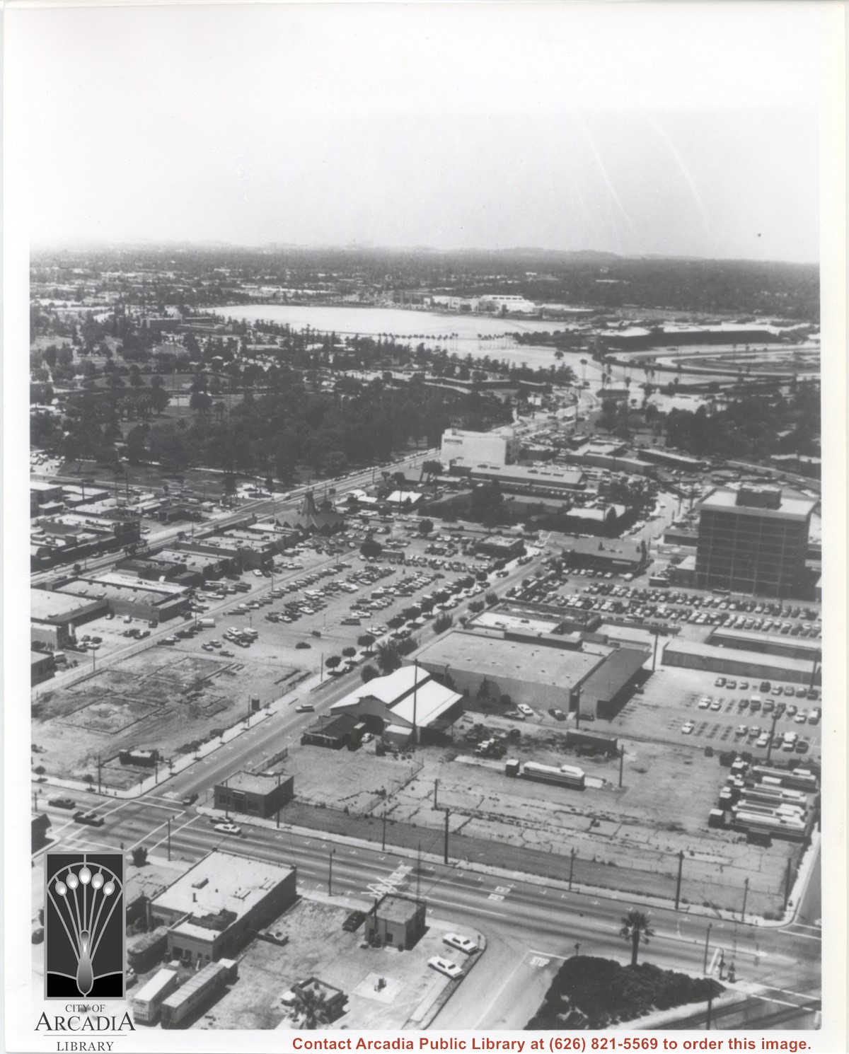
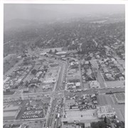
Aerial view looking west from a position approximately over Santa Fe railroad tracks between First Avenue and Second Avenue. Street closest to camera is First Avenue, running north/south, and we see its intersection with Wheeler Avenue in lower left portion of photo. Almost vacant lot on northwest corner of Wheeler Avenue and First Avenue is where Sawmill Restaurant was built in about 1977 (Sawmill Restaurant closed in early 1990's). Foundation work on South side of Wheeler Avenue at corner of First Avenue is for medical building which became 65 N. First Avenue. (Former site of Arcadia Public Library until 1961.) Post Office is largest building in center of the block on north side of Wheeler Avenue. Large white area is parking area for Santa Anita Park Race Track.
https://arcadiahistory.andornot.com/en/permalink/photographs640
- Date
- July 1976
1 image
- Date
- July 1976
- Subjects
- Aerial Photo Collection
- Aerial views
- First Avenue
- Postal Service
- Santa Anita Park-1945-1980
- United States Post Office
- Wheeler Avenue
- Physical Description
- 8x10 b&w
- ID
- 636
- Collection
- Photographs
Images
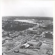
Aerial view north toward San Gabriel Mountains from a position above Huntington Drive near First Avenue. Santa Anita Avenue can plainly be seen running north and south in front of six-story building in center of photo. The 210 Foothill Freeway is top band running across photo from east to west.
https://arcadiahistory.andornot.com/en/permalink/photographs611
- Date
- July 1976
1 image

A house-to-house survey of registered voters in Annexation Area 80-2 shows that most of the voters favor annexation by Arcadia over Temple City. Article gives the breakdown by street. The area is an "island" bounded by Temple City Blvd. on the west, Longden Ave. on the south, and the Arcadia boundary on the north and east.
https://arcadiahistory.andornot.com/en/permalink/newspaper415
- Newspaper
- Arcadia Tribune
- Date
- July 25, 1982
- Pages
- p. A-1
- Subjects
- Annexation (Municipal Government)
- Item ID
- 415AN
- Collection
- Newspaper Index
Public hearings will be held in re proposed residential development north of Foothills Junior High School. The first hearing will discuss only the environmental impact report.
https://arcadiahistory.andornot.com/en/permalink/newspaper1193
- Newspaper
- Arcadia Tribune
- Date
- December 3, 1978
- Pages
- p. A-1
- Subjects
- City Planning
- Item ID
- 1192AN
- Collection
- Newspaper Index
Article reports on progress with two parcels involving a proposed Hometel 300-room hotel at the northeast corner of Second Avenue and Huntington Drive and a proposed office building at the southwest corner of Huntington Drive and Fifth Avenue.
https://arcadiahistory.andornot.com/en/permalink/newspaper1276
- Newspaper
- Arcadia Tribune
- Date
- August 7, 1980
- Pages
- p. A-1
- Subjects
- Community Redevelopment
- Item ID
- 1275AN
- Collection
- Newspaper Index
The City of Arcadia wants to assist in the redevelopment of South Arcadia businesses around Live Oak and Las Tunas. The city will hold a hearing July 3 for the environmental impact report on a plan that has been proposed. The area in question covers 75 acres.
https://arcadiahistory.andornot.com/en/permalink/newspaper29712
- Newspaper
- Arcadia Weekly
- Date
- May 24, 2001
- Pages
- p. 1
- Subjects
- Redevelopment
- South Arcadia
- Item ID
- 29897AN
- Collection
- Newspaper Index
Arcadia's new city government first formed in 1903 and its first meeting took place at Elias J. "Lucky" Baldwin's Oakwood Hotel, located at First Avenue and Santa Clara Road. Baldwin's hotel featured gambling and fine dining along with city government. The Oakwood Hotel burned down in 1911, and the city government moved to the McCoy Building at First Avenue and St. Joseph Street. Two years later, City Hall moved across the street to the Hibbard Building. In 1917, the first building was constructed as a City Hall at Huntington Drive and Second Avenue (?). A two-story colonial building was built for $18,000. This City Hall opened on July 13, 1918. City Hall moved in 1949 to a 13-acre parcel between Huntington Drive and the Pacific Electric railroad tracks.
https://arcadiahistory.andornot.com/en/permalink/newspaper31749
- Newspaper
- Arcadia Weekly
- Date
- July 17, 2003
- Pages
- p. 1, 18
- Item ID
- 31946AN
- Collection
- Newspaper Index
Construction will begin on a 14 foot high sound wall along the westbound lanes of the 210 freeway between Second and Fifth Avenues.
https://arcadiahistory.andornot.com/en/permalink/newspaper21227
- Newspaper
- Pasadena Star News
- Date
- July 9, 2001
- Pages
- p. A1
- Subjects
- Freeways
- Item ID
- 21454AN
- Collection
- Newspaper Index
The proposed site for Arcadia's Gold Line station is just east of Santa Anita Avenue, at the First Avenue/Santa Clara intersection. City leaders want to separate the railroad tracks from the street.
https://arcadiahistory.andornot.com/en/permalink/newspaper28351
- Newspaper
- Pasadena Star News
- Date
- May 19, 2004
- Pages
- p. A3
- Item ID
- 28548AN
- Collection
- Newspaper Index
The Arcadia City Council has approved the environmental impact report for a proposed hillside subdivision north of Foothills Junior High School. Public hearings will follow.
https://arcadiahistory.andornot.com/en/permalink/newspaper1194
- Newspaper
- Arcadia Tribune
- Date
- December 7, 1978
- Pages
- p. A-1
- Subjects
- City Planning
- Item ID
- 1193AN
- Collection
- Newspaper Index
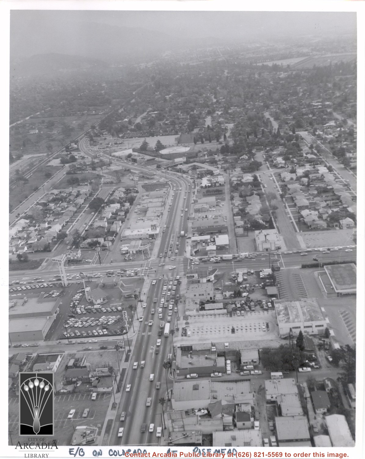
Aerial view looking east into Arcadia from near intersection of Rosemead Boulevard and Colorado Boulevard. Eaton's Santa Anita Hotel and Restaurant is still seen at far end of curve on south side of Colorado Boulevard and Michillinda Avenue (this is present site of Coco's Restaurant and Oak Tree Banquet Room, formerly Reuben's Restaurant, address 1150 W. Colorado Boulevard). The Santa Fe Railroad Tracks are seen just north of Colorado Boulevard. Large clear area in upper right portion of photo is Santa Anita Park Race Track.
https://arcadiahistory.andornot.com/en/permalink/photographs638
- Date
- c.1970
1 image
- Date
- c.1970
- Subjects
- Aerial Photo Collection
- Aerial views
- Colorado Boulevard
- Colorado Street
- Eaton's Santa Anita Hotel and Restaurant (1939-1969)
- Michillinda Avenue
- Railroads
- Santa Anita Park-1945-1980
- Physical Description
- 8x10 b&w
- ID
- 634
- Collection
- Photographs
Images
About 1000 feet of sound walls will be built by the westbound lanes of the 210 Foothill Freeway between Second Avenue and Fifth Avenue. There is also discussion of future sound wall construction projects.
https://arcadiahistory.andornot.com/en/permalink/newspaper30026
- Newspaper
- Arcadia Weekly
- Date
- July 12, 2001
- Pages
- p. 1, 10
- Item ID
- 30213AN
- Collection
- Newspaper Index
There was a groundbreaking ceremony on Tuesday for an Extended Stay America hotel on Santa Clarita just east of Second Avenue.
https://arcadiahistory.andornot.com/en/permalink/newspaper10707
- Newspaper
- Sierra Madre News
- Date
- October 2, 1997
- Pages
- p. 9
- Item ID
- 10634AN
- Collection
- Newspaper Index
The Arcadia Board of Education will study the environmental impact of new uses and the addition of lights at Dana and First Avenue Middle schools and the Arcadia High School softball field.
https://arcadiahistory.andornot.com/en/permalink/newspaper26887
- Newspaper
- Arcadia Weekly
- Date
- March 25, 1999
- Pages
- p. 1
- Item ID
- 27087AN
- Collection
- Newspaper Index