A profile of Ralph's Florist at 109 South First Avenue and original owner Ralph Yaish (Yack) and son Allen Yack.
https://arcadiahistory.andornot.com/en/permalink/newspaper25805
- Newspaper
- Arcadia Weekly
- Date
- February 20, 1997
- Pages
- p. 4
- Item ID
- 26005AN
- Collection
- Newspaper Index
A profile of Jack Lamb and Glasser-Miller-Lamb Arcadia Mortuary at 500 S. First Avenue.
https://arcadiahistory.andornot.com/en/permalink/newspaper25825
- Newspaper
- Arcadia Weekly
- Date
- May 15, 1997
- Pages
- p. 4
- Item ID
- 26025AN
- Collection
- Newspaper Index
A profile of Barbara's Beauty Supplies and Boutique and the owner, Barbara Pohlen Budd. Her store is located at 127 South First Avenue.
https://arcadiahistory.andornot.com/en/permalink/newspaper25809
- Newspaper
- Arcadia Weekly
- Date
- March 20, 1997
- Pages
- p. 4
- Item ID
- 26009AN
- Collection
- Newspaper Index
Items regarding First Avenue
https://arcadiahistory.andornot.com/en/permalink/newspaper4390
- Newspaper
- Arcadia Tribune
- Date
- August 3, 1934 p. A-6 (photo of corner at Huntington Drive)
- January 5, 1947 p. 1 (extension)
- January 30, 1947 p. 1 (picture)
- March 4, 1954 p. 1 (widening)
- December 4, 1961 p. 1 (railroad crossing gate)
- Newspaper
- Arcadia Tribune
- Date
- August 3, 1934 p. A-6 (photo of corner at Huntington Drive)
- January 5, 1947 p. 1 (extension)
- January 30, 1947 p. 1 (picture)
- March 4, 1954 p. 1 (widening)
- December 4, 1961 p. 1 (railroad crossing gate)
- Subjects
- Streets - First Avenue
- Item ID
- 4266AN
- Collection
- Newspaper Index
On First Avenue, business owners are elated with the way construction related to the city's Downtown 2000 has worked out.
https://arcadiahistory.andornot.com/en/permalink/newspaper5663
- Newspaper
- Pasadena Star News
- Date
- December 4, 1995
- Pages
- p. A1
- Item ID
- 5514AN
- Collection
- Newspaper Index
Merchants on First Avenue question whether the Farmers Market should be continued.
https://arcadiahistory.andornot.com/en/permalink/newspaper26480
- Newspaper
- Arcadia Weekly
- Date
- December 3, 1998
- Pages
- p. 1
- Subjects
- Farmers Market
- Streets - First Avenue
- Item ID
- 26681AN
- Collection
- Newspaper Index
Baldwin Avenue extension south from Huntington Drive to Ramona Boulevard has been approved.
https://arcadiahistory.andornot.com/en/permalink/newspaper33017
- Newspaper
- The Journal
- Date
- January 11, 1950
- Pages
- p. 6 Section 2 (See basement box 112.)
- Newspaper
- The Journal
- Date
- January 11, 1950
- Pages
- p. 6 Section 2 (See basement box 112.)
- Subjects
- Baldwin Avenue
- Streets
- Item ID
- 33214AN
- Collection
- Newspaper Index
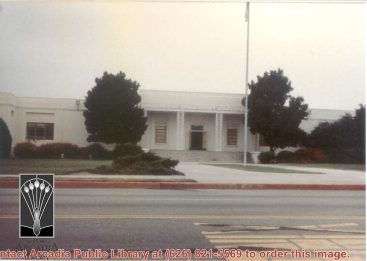
First Avenue Middle School, 301 South 1st Avenue, Arcadia, CA. Photograph by Terry Miller.
https://arcadiahistory.andornot.com/en/permalink/photographs2317
- Date
- 2001
1 image
- Date
- 2001
- Subjects
- Middle schools
- First Avenue Middle School
- Physical Description
- 4x6 b&w
- ID
- 2240
- Collection
- Photographs
Images
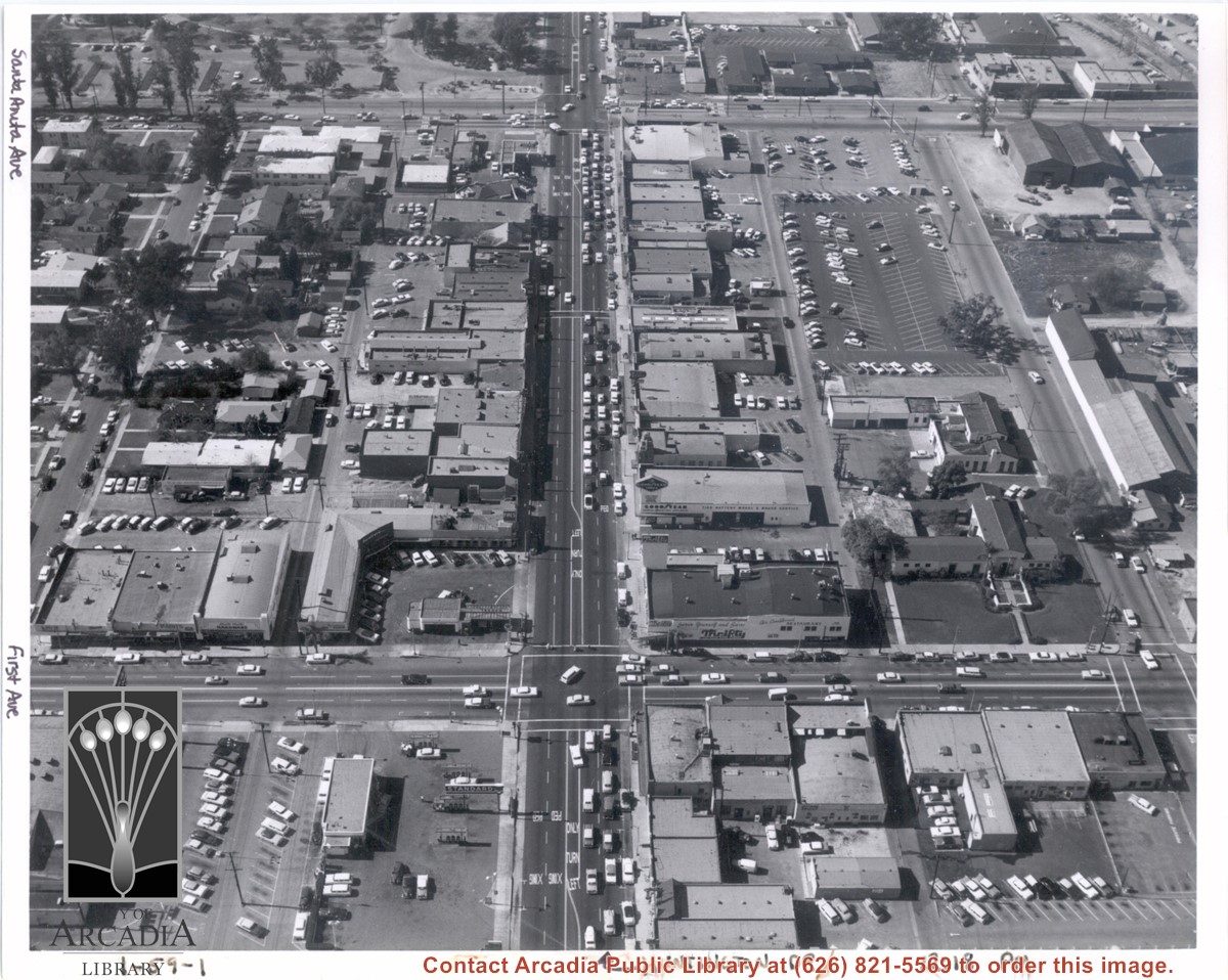
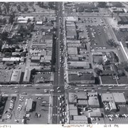
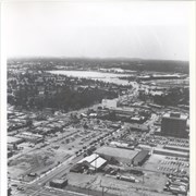
Aerial view from above Huntington Drive between Santa Anita Avenue and First Avenue. Huntington Drive intersects the photo from north to south. The street closest to the bottom is First Avenue and Santa Anita Avenue is near the top.
https://arcadiahistory.andornot.com/en/permalink/photographs1403
- Date
- c.1959
1 image
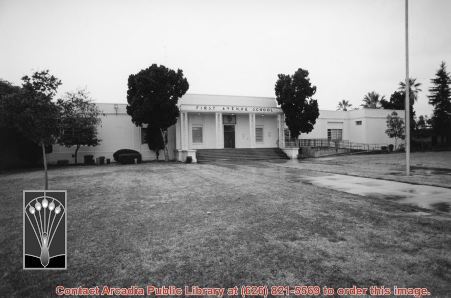
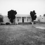
Entrance to First Avenue Junior High School (later known as First Avenue Middle School).
https://arcadiahistory.andornot.com/en/permalink/photographs1243
- Date
- 1979
1 image
Aerial view toward NE. Plane is over property of Charles W. Stewart (10 acres), and Jaspar Teague (10 acres), at 1320 S. Santa Anita Avenue, which is directly under the plane. Next street east is First Avenue, then Second Avenue, the Fourth Avenue. Reservoir is at corner of Valnett Avenue and Second Avenue and was owned by Walnut Grove Mutual Water Company (Valnett Avenue was first through street south of Duarte Road at this time and became Camino Real).
https://arcadiahistory.andornot.com/en/permalink/photographs644
- Date
- November 1929
1 image
- Date
- November 1929
- Subjects
- Aerial Photo Collection
- Aerial views
- Camino Real
- Duarte Road
- First Avenue
- Fourth Avenue
- Second Avenue
- Santa Anita Avenue (South)
- Stewart, Charles W.
- Teague, Jaspar
- Valnett Avenue
- Physical Description
- 6x10 b&w
- ID
- 640
- Collection
- Photographs
Images


Items regarding Fourth Avenue
https://arcadiahistory.andornot.com/en/permalink/newspaper4402
- Newspaper
- Arcadia Tribune
- Date
- August 18, 1958 p. 1 (improvement)
- Subjects
- Streets - Fourth Avenue
- Item ID
- 4278AN
- Collection
- Newspaper Index
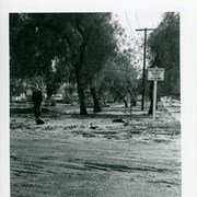
Flood damage on N. Santa Anita Avenue. A sign reads "FIRST BAPTIST CHURCH a MILE." There is an unidentified man walking toward the camera on the left.
https://arcadiahistory.andornot.com/en/permalink/photographs1439
- Date
- March 1954
1 image
- Date
- March 1954
- Subjects
- Streets-Santa Anita Avenue
- Floods
- Physical Description
- 3x4
- ID
- 1426
- Collection
- Photographs
Images

First Avenue School class picture of teacher and students. No identification.
https://arcadiahistory.andornot.com/en/permalink/photographs1736
- Date
- circa 1940s
1 image
- Date
- circa 1940s
- Subjects
- First Avenue School
- Physical Description
- 5x7 b&w
- ID
- 1724
- Collection
- Photographs
Images


First Avenue School class picture of teacher and students. No identification.
https://arcadiahistory.andornot.com/en/permalink/photographs1737
- Date
- circa 1940s
1 image
- Date
- circa 1940s
- Subjects
- First Avenue School
- Physical Description
- 5x7 b&w
- ID
- 1725
- Collection
- Photographs
Images


First Avenue School class picture of teacher and students. No identification.
https://arcadiahistory.andornot.com/en/permalink/photographs1738
- Date
- circa 1940s
1 image
- Date
- circa 1940s
- Subjects
- First Avenue School
- Physical Description
- 5x7 b&w
- ID
- 1726
- Collection
- Photographs
Images


First Avenue School class picture of teacher and students. No identification.
https://arcadiahistory.andornot.com/en/permalink/photographs1739
- Date
- circa 1940s
1 image
- Date
- circa 1940s
- Subjects
- First Avenue School
- Physical Description
- 5x7 b&w
- ID
- 1727
- Collection
- Photographs
Images


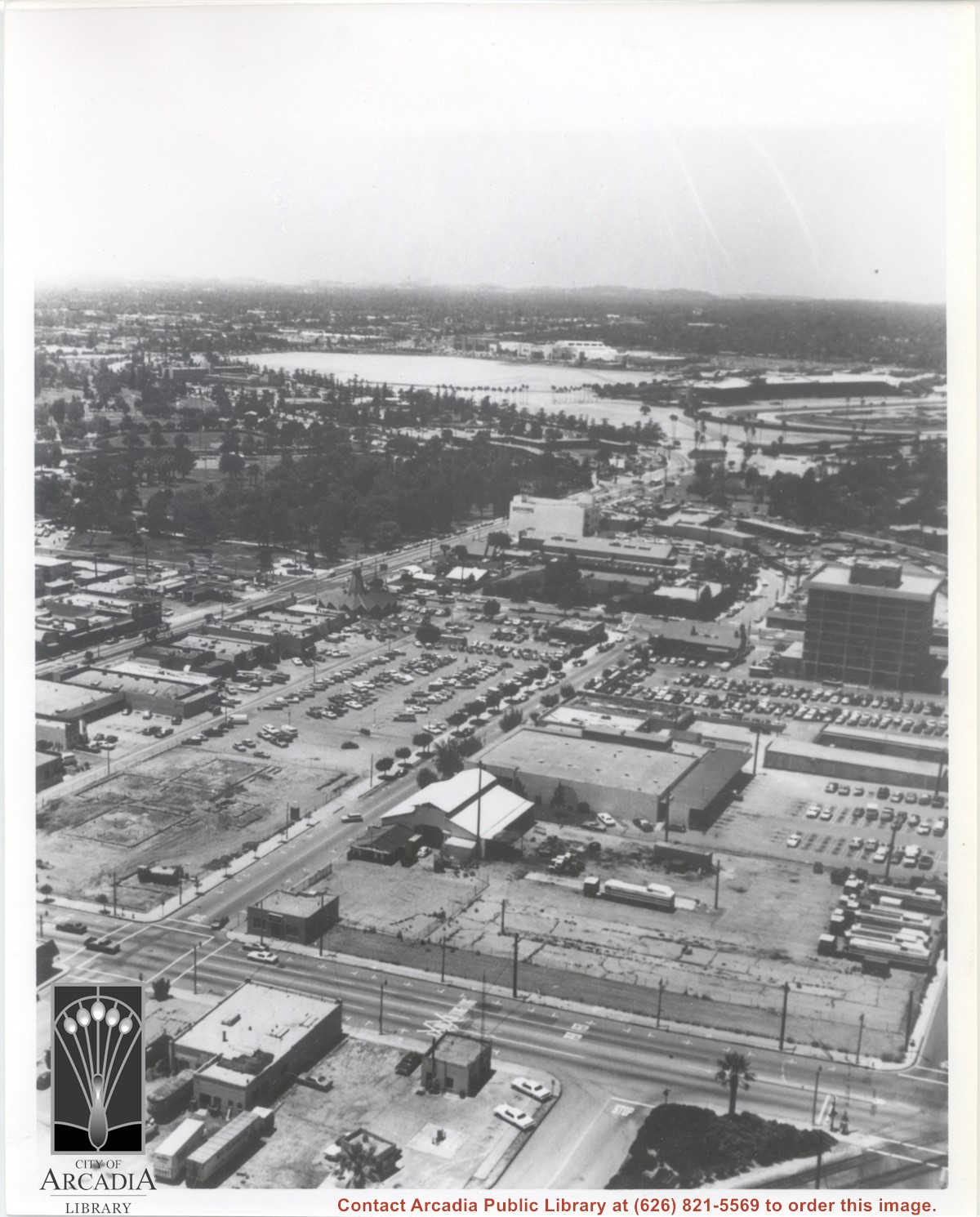
Aerial view looking west from a position approximately over Santa Fe railroad tracks between First Avenue and Second Avenue. Street closest to camera is First Avenue, running north/south, and we see its intersection with Wheeler Avenue in lower left portion of photo. Almost vacant lot on northwest corner of Wheeler Avenue and First Avenue is where Sawmill Restaurant was built in about 1977 (Sawmill Restaurant closed in early 1990's). Foundation work on South side of Wheeler Avenue at corner of First Avenue is for medical building which became 65 N. First Avenue. (Former site of Arcadia Public Library until 1961.) Post Office is largest building in center of the block on north side of Wheeler Avenue. Large white area is parking area for Santa Anita Park Race Track.
https://arcadiahistory.andornot.com/en/permalink/photographs640
- Date
- July 1976
1 image
- Date
- July 1976
- Subjects
- Aerial Photo Collection
- Aerial views
- First Avenue
- Postal Service
- Santa Anita Park-1945-1980
- United States Post Office
- Wheeler Avenue
- Physical Description
- 8x10 b&w
- ID
- 636
- Collection
- Photographs
Images
Profile on local Arcadia business The Book Rack at 204 South First Avenue and its owner Karen Klopp.
https://arcadiahistory.andornot.com/en/permalink/newspaper34464
- Newspaper
- Arcadia Weekly
- Date
- February 18, 2016
- Pages
- p. 16
- Item ID
- 34656AN
- Collection
- Newspaper Index
Arcadia wants to declare a section of Live oak Avenue and Las Tunas Drive in south Arcadia a redevelopment zone to qualify for county funding. The County says area is not blighted and does not meet qualifications for funding.
https://arcadiahistory.andornot.com/en/permalink/newspaper24414
- Newspaper
- Pasadena Star News
- Date
- September 7, 2002
- Pages
- p. A1
- Item ID
- 24604AN
- Collection
- Newspaper Index