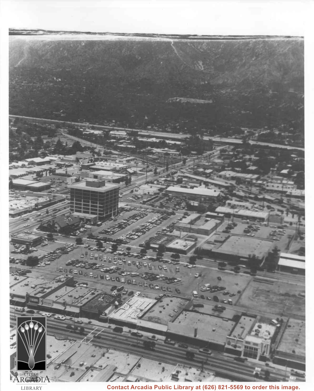
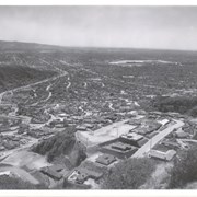
Aerial view north toward San Gabriel Mountains from a position above Huntington Drive near First Avenue. Santa Anita Avenue can plainly be seen running north and south in front of six-story building in center of photo. The 210 Foothill Freeway is top band running across photo from east to west.
https://arcadiahistory.andornot.com/en/permalink/photographs611
- Date
- July 1976
1 image

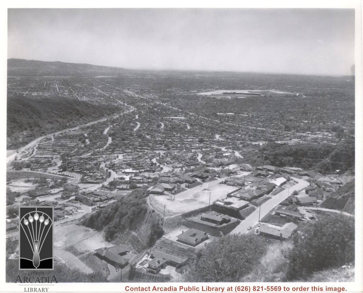
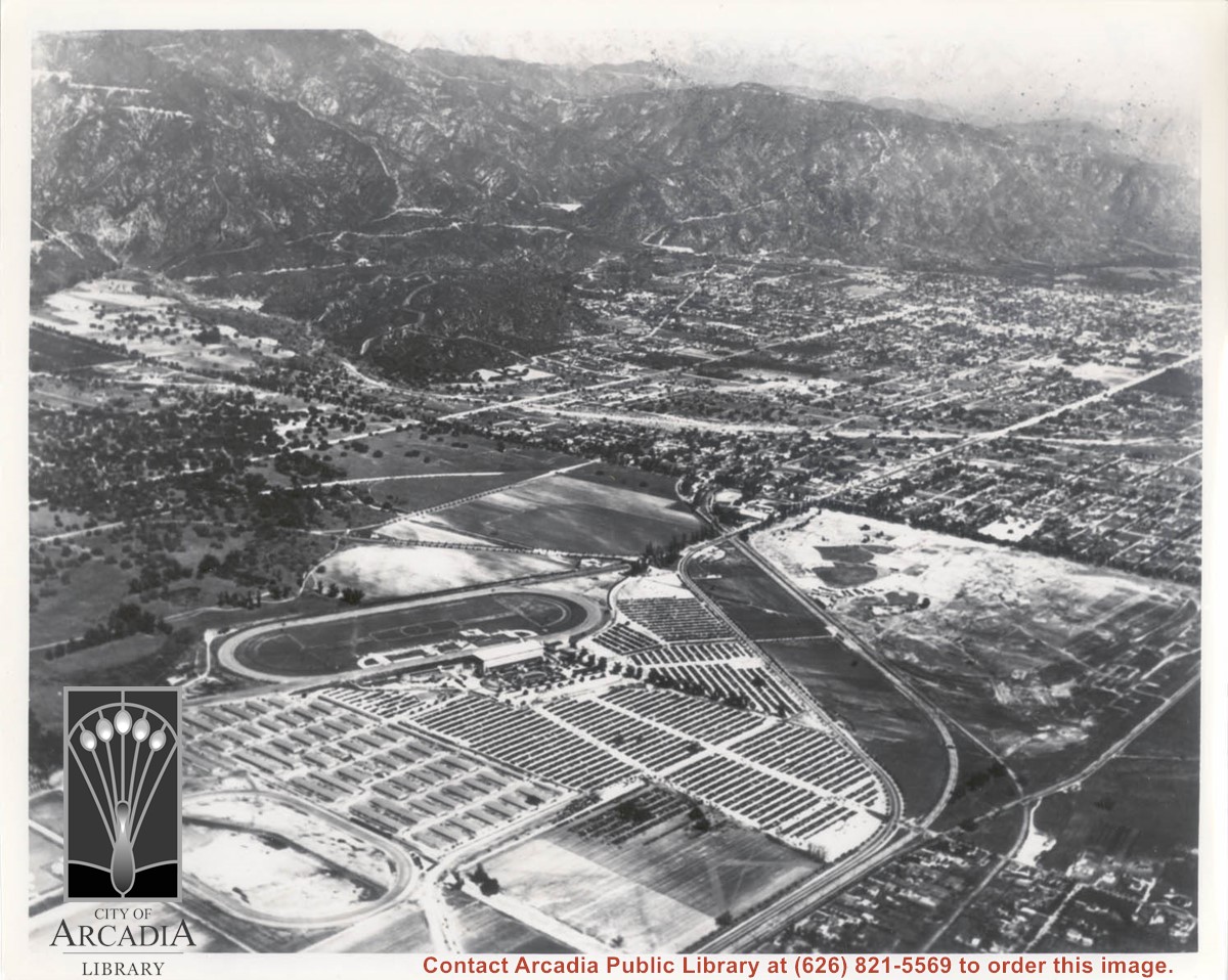
Aerial view south from Chantry Flats Road over the still-developing upper Highlands section of Arcadia. View is across Arcadia toward the Puente Hills. Santa Anita Park Race Track is seen in the center. Santa Anita Wash is seen on extreme left.
https://arcadiahistory.andornot.com/en/permalink/photographs955
- Date
- c.1965
1 image
- Date
- c.1965
- Subjects
- Aerial Photo Collection
- Aerial views
- Arcadia(City)-History-1960-1969
- Chantry Flats Road
- Santa Anita Wash
- Physical Description
- 8x10 b&w
- ID
- 949
- Collection
- Photographs
Images
Aerial view, of the white A-Frame roof of Santa Anita Church (address is 226 West Colorado Boulevard, Arcadia, California). A six-sided, hexagon building near Santa Anita Church is the Fireside Room and Fellowship Hall, which is part of the Santa Anita Church. Any use of this image must be credited "Photograph by David Stevens. Copyright David Stevens."
https://arcadiahistory.andornot.com/en/permalink/photographs2420
- Date
- 1990?
1 image
- Date
- 1990?
- Physical Description
- color image, digital, see i:images
- ID
- 2278
- Collection
- Photographs
Images
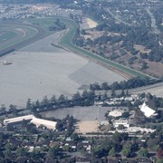
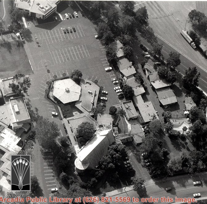
Aerial view, of Santa Anita Park Race Track in the upper left quadrant (address is 285 West Huntington Drive) and the white A-Frame roof of Santa Anita Church (address is 226 West Colorado Boulevard) in the lower right quadrant. A six-sided, hexagon building seen to the left of Santa Anita Church, is the Fireside Room and Fellowship Hall, which is part of the Santa Anita Church. Any use of this image must be credited "Photograph by David Stevens. Copyright David Stevens."
https://arcadiahistory.andornot.com/en/permalink/photographs2416
- Date
- 1990?
1 image
- Date
- 1990?
- Subjects
- Aerial Photo Collection
- Aerial views
- David Stevens Collection
- Santa Anita Church
- Santa Anita Park
- Physical Description
- color image, digital, see i:images
- ID
- 2274
- Collection
- Photographs
Images

Aerial view looking northeast across Santa Anita Park toward mountains. Note training track called Anita Chiquita has been added (lower left corner), open grandstand has been added to west of covered stand. Note, too, that work has begun to change Balloon School site to Arcadia County Park. Santa Anita Avenue is tree-lined street running entire width of photo about middle of print.
https://arcadiahistory.andornot.com/en/permalink/photographs987
- Date
- 1937
1 image
- Date
- 1937
- Subjects
- Aerial Photo Collection
- Aerial views
- Anita Chiquita training track
- Arcadia County Park
- Balloon School
- Santa Anita Avenue
- Santa Anita Park-1934-1942
- Physical Description
- 8x10 b&w
- ID
- 979
- Collection
- Photographs
Images
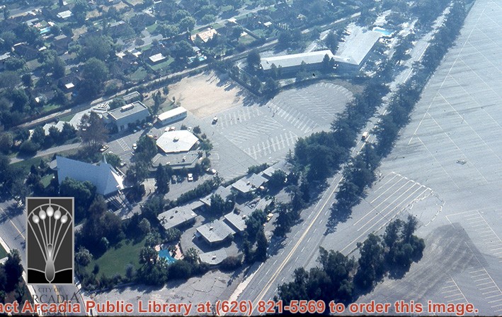
Aerial view, of the white A-Frame roof of Santa Anita Church (address is 226 West Colorado Boulevard, Arcadia, California). A six-sided, hexagon building near Santa Anita Church is the Fireside Room and Fellowship Hall, which is part of the Santa Anita Church. The church property goes all the way to Colorado Place (including "The Village Apartments," formerly the Frontier Motel, which the church purchased in 1972) and includes the parking lot and the building at the top of the photo, the Margaret Stevens Center. Any use of this image must be credited "Photograph by David Stevens. Copyright David Stevens."
https://arcadiahistory.andornot.com/en/permalink/photographs2421
- Date
- 1990?
1 image
- Date
- 1990?
- Physical Description
- color image, digital, see i:images
- ID
- 2279
- Collection
- Photographs
Images
Aerial view of what appears to be either an informal horse show or possible horse sale with a great number of people in attendance. The location has been identified as near intersection of Las Tunas Drive and (with what seem to be railroad tracks in center) Temple City Boulevard. The building (we see only roof) in the lower left corner is Vernon's Pharmacy. The letters VGS can be seen over front entry. There are probably about 100 autos parked nearby. (There is another photo of this event, #539.)
https://arcadiahistory.andornot.com/en/permalink/photographs647
- Date
- c. early 1930's
1 image


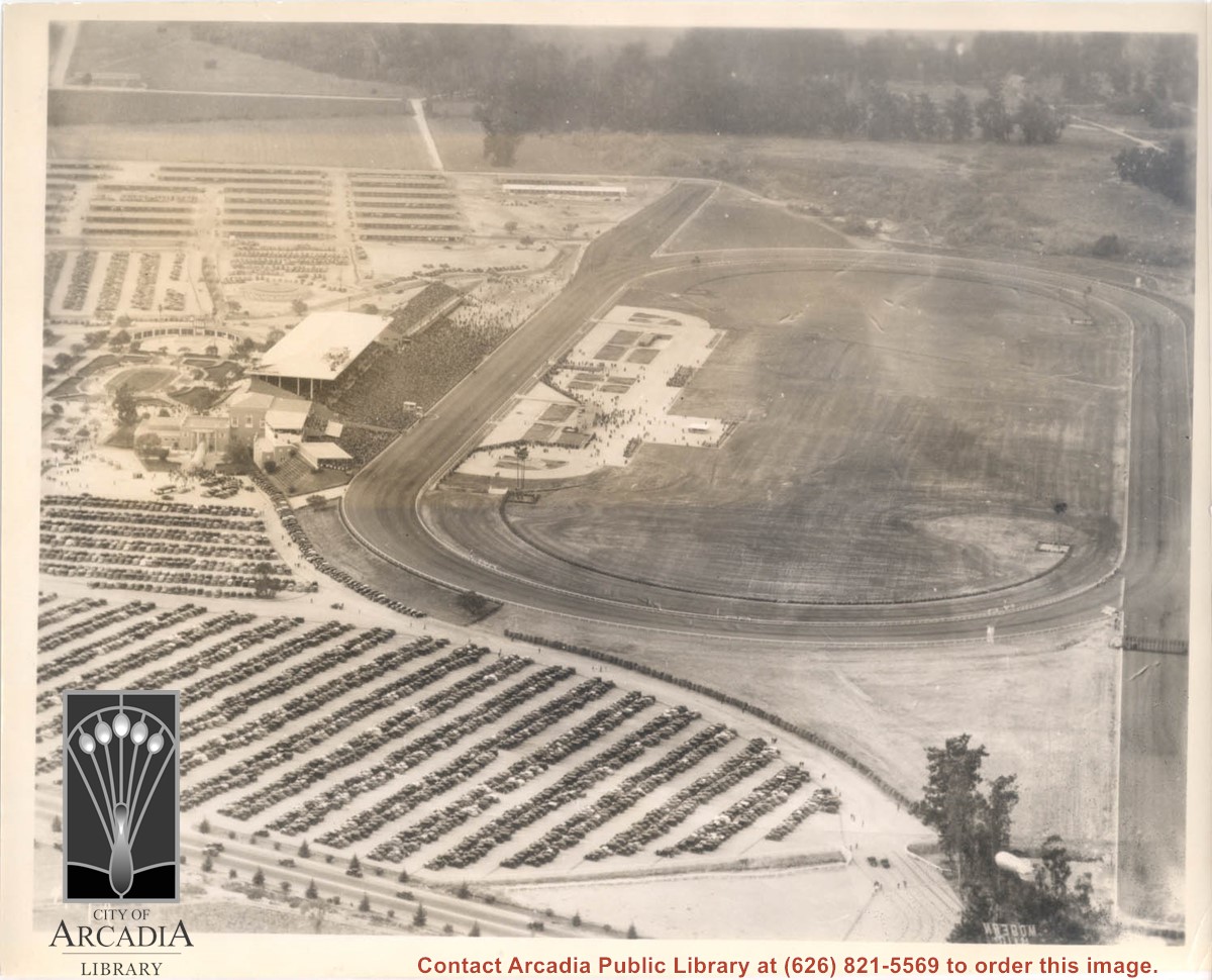
Aerial view looking west over Santa Anita Park. Photo was taken from about over intersection of Colorado Place and Huntington Drive. Note area that was to become Los Angeles County Arboretum across top of photo. Note an open Grandstand has been added to the west of original covered one. There is a small dirigible in lower right corner carrying a sign that seems to read:modern motel. Present Baldwin Avenue would run where road in this photo is seen parallel to top of photo.
https://arcadiahistory.andornot.com/en/permalink/photographs983
- Date
- December 28, 1935
1 image
- Date
- December 28, 1935
- Physical Description
- 8x10 b&w
- ID
- 975
- Collection
- Photographs
Images