14 year old Luis Espinoza shot the low score as the Rancho Duarte Golf Course team won the Junior Metro Golf League tournament in Banning.
https://arcadiahistory.andornot.com/en/permalink/newspaper21609
- Newspaper
- Pasadena Star News
- Date
- September 4, 2001
- Pages
- p. A4
- Subjects
- Espinoza, Luis
- Item ID
- 21830AN
- Collection
- Newspaper Index
A 75-year-old building at 330 East Duarte Road, which was purchased as a chapel for the Wesleyan Holiness Community Chapel Church, is considered to be unsafe and "in complete disrepair" by the Arcadia Planning Commission.
https://arcadiahistory.andornot.com/en/permalink/newspaper954
- Newspaper
- Arcadia Tribune
- Date
- February 28, 1988
- Pages
- p. 1
- Item ID
- 954AN
- Collection
- Newspaper Index
The 121-unit Marriott Residence Inn is scheduled to open for business on January 23. An "all-suites" hotel, the inn offers kitchens in every unit to entice "extended-stay" travellers.
https://arcadiahistory.andornot.com/en/permalink/newspaper1833
- Newspaper
- Arcadia Tribune
- Date
- January 11, 1989
- Pages
- p. A-1 photo
- Item ID
- 1832AN
- Collection
- Newspaper Index
210 Freeway closure creates 5-mile backup for 5 days. 605 Freeway also affected by work on a bridge. Caltrans is repairing a 50-year-old concrete bridge on the 210 Freeway spanning the San Gabriel River. Most affected were motorists and truckers from eastern Los Angeles County and Inland Empire, driving the preferred route into Irwindale, Duarte, Arcadia, Monrovia, Pasadena, and San Fernando Valley.
https://arcadiahistory.andornot.com/en/permalink/newspaper36284
- Newspaper
- Pasadena Star News
- Date
- July 22, 2022
- Pages
- p. A3, A4
- Collection
- Newspaper Index
210 Freeway closure returns this week. For second time in a month, motorists face delays during a 5-day shutdown for bridge construction, closing eastbound lanes of the 210 Freeway from the 605 Freeway interchange to Irwindale Avenue. The delays may be more pronounced in the weekday afternoon during peak hours through Pasadena, Arcadia, Monrovia, Duarte, and Irwindale, as the eastbound lanes detour from 6 lanes into 3 lanes.
https://arcadiahistory.andornot.com/en/permalink/newspaper36306
- Newspaper
- Pasadena Star News
- Date
- August 15, 2022
- Pages
- p. A1, A7
- Collection
- Newspaper Index
210 Freeway sound wall is finished. The Metro project, which started in 2009, consists of 2 miles of sound walls along westbound and eastbound lanes of the 210 Freeway between Santa Anita Avenue and California Avenue in Arcadia and Monrovia, paid with Measure R funds. The sound walls provide at least 5 decibels of noise reduction. A ribbon cutting ceremony was held. Several Arcadia residents near Victory Chapel on N. First Avenue, where the sound wall ends, are disappointed the barrier doesn't extend farther west.
https://arcadiahistory.andornot.com/en/permalink/newspaper33107
- Newspaper
- Pasadena Star News
- Date
- July 17, 2012
- Pages
- p. A3
- Item ID
- 33304AN
- Collection
- Newspaper Index
2020 ELECTIONS - Outcomes for boards of college districts - Open seats draw range of challengers to lead local higher education. Citrus Community College In Area 2, Laura Bollinger had an early lead over Joseph Hamer Salas for the Citrus Community College District race. The Citrus Community College District encompasses Azusa, Bradbury, Claremont, Duarte, Glendora, Monrovia, and portions of San Dimas, La Verne, Pomona, Arcadia, Covina and Irwindale. The district enrolls more than 20,000 students.
https://arcadiahistory.andornot.com/en/permalink/newspaper35828
- Newspaper
- Pasadena Star News
- Date
- November 4, 2020
- Pages
- p. A5
- Subjects
- Citrus Community College
- Elections-2020
- Collection
- Newspaper Index
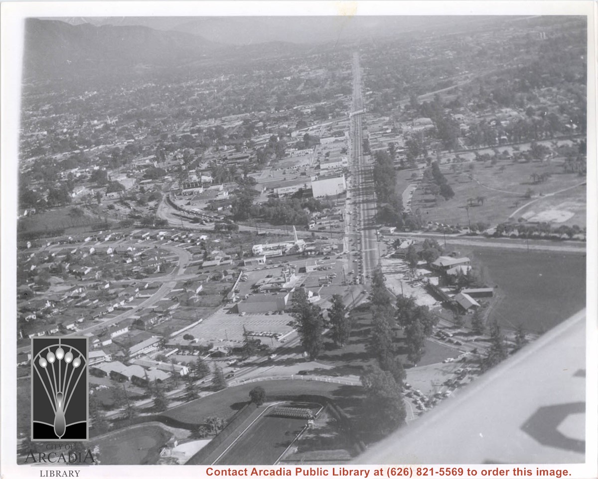
Aerial view looking east along Huntington Drive taken over the Club House at Santa Anita Park Race Track. Pony Express Museum is just to right of the "y" intersection of Huntington Drive coming into Arcadia just below the wing of the plane. Theater that was opened in 1942 is almost directly opposite Museum. Santa Anita Motor Inn, two buildings east of theater, distinguished by tall tower, opened in 1938. (It was torn down in 1975.) The residential area directly north of there is known as Santa Anita Gardens. Santa Anita Avenue is just beyond Arcadia County Park on right.
https://arcadiahistory.andornot.com/en/permalink/photographs642
- Date
- c. 1957-58
1 image
- Date
- c. 1957-58
- Subjects
- Aerial Photo Collection
- Aerial views
- Huntington Drive
- Pony Express Museum
- Santa Anita Avenue
- Santa Anita Motor Inn
- Physical Description
- 8x10 b&w
- ID
- 638
- Collection
- Photographs
Images
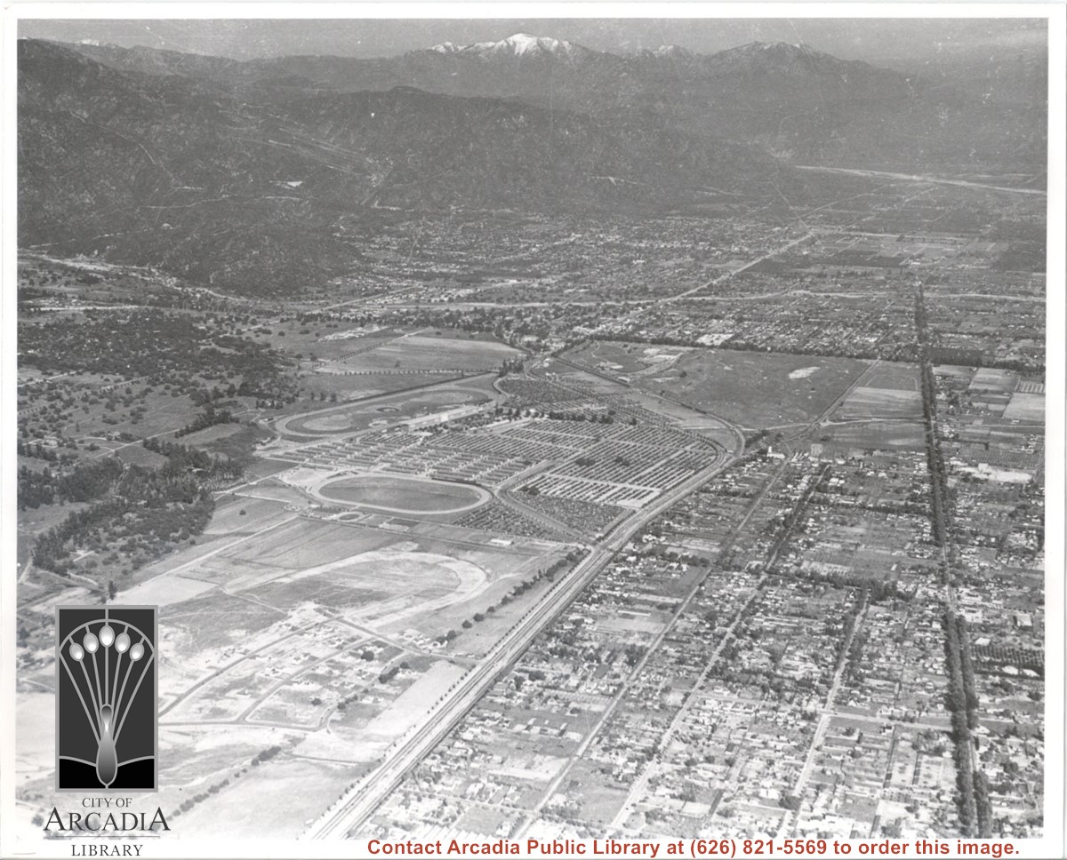
Aerial view. Looking east. Street along right edge of photo which is lined with trees is Duarte Road. Santa Anita Avenue cuts across photo from right to left and up into the San Gabriel Mountains. Huntington Drive can be seen in center of photo with young trees planted on north side of it. Santa Anita Race Track is one furthest from camera. The next small track is a training track belonging to Santa Anita. There is a VERY small round track across the street from the training track, which was part of a private horse stables. The incompleted oval was part of work done in 1933 by Joe Smoot and Anita Baldwin in their effort to develop the Jockey Club Track. This photo belongs to the Huntington Library. It is shown here for research only.
https://arcadiahistory.andornot.com/en/permalink/photographs627
- Date
- c. 1935
1 image
- Date
- c. 1935
- Subjects
- Duarte Road
- Huntington Drive
- Los Angeles Jockey Club
- San Gabriel Mountains
- Santa Anita Park-1934-1942
- Physical Description
- 8x10 b&w
- ID
- 623
- Collection
- Photographs
Images
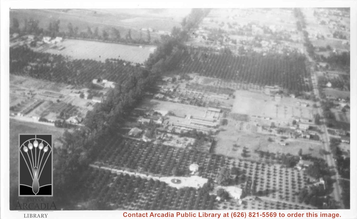
Aerial view north. Main tree-lined street is Santa Anita Avenue. Most of the orange grove in center of photo was owned by Jaspar Teague family. They had built a circular art gallery on their property at 1380 South Santa Anita Avenue. The large buildings north of Teague's and to the west of Santa Anita Avenue are chicken houses. Duarte Road is the east/west street across photo near top of photo.
https://arcadiahistory.andornot.com/en/permalink/photographs645
- Date
- November 1929
1 image
- Date
- November 1929
- Subjects
- Aerial Photo Collection
- Aerial views
- Agriculture
- Duarte Road
- Orange groves
- Poultry
- Santa Anita Avenue
- Teague, Jaspar
- Physical Description
- 6x10 b&w
- ID
- 641
- Collection
- Photographs
Images
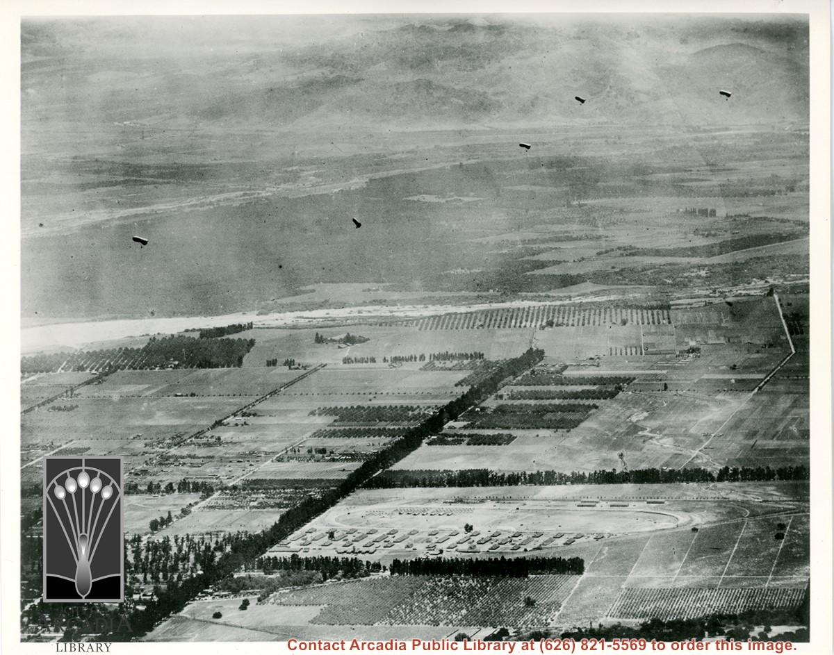
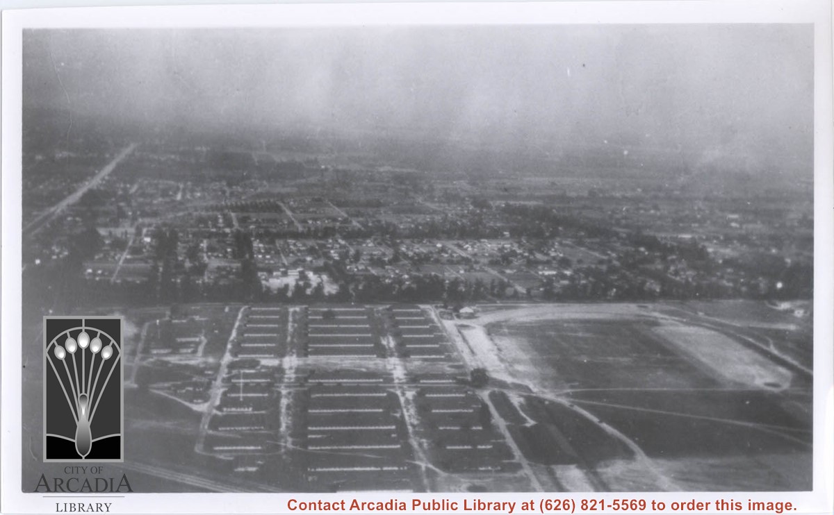
Aerial view south of Balloon School and surrounding part of valley. Large tree-lined street running from center of photo toward lower left edge of photo is Santa Anita. Tree-lined street coming in on right edge of photo about two inches from bottom of photo and intersecting Santa Anita, is Duarte Road. Note wash that at present is just west of Arcadia High School. Rio Hondo Wash runs east to west across middle of photo.
https://arcadiahistory.andornot.com/en/permalink/photographs153
- Date
- c.1918
1 image
- Date
- c.1918
- Subjects
- Aerial Photo Collection
- Aerial views
- U.S. Army Balloon School see Balloon School
- Balloon School
- Physical Description
- 8x10 b&w
- ID
- 152
- Collection
- Photographs
Images
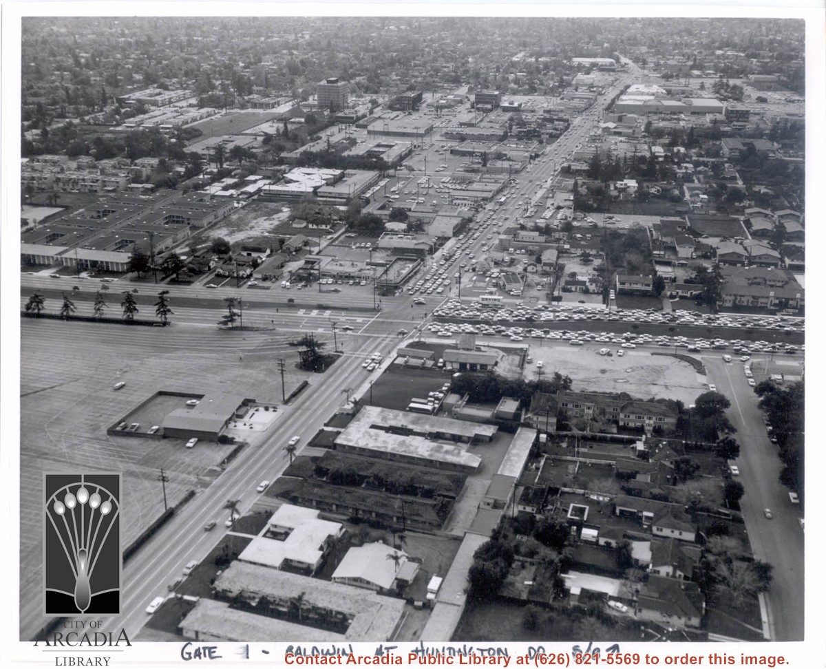
Aerial view south on Baldwin Avenue. From position just north of Huntington Drive (during racing season) showing great number of cars coming east on Huntington Drive to races through Gate #1. One building in Santa Anita Park Race Track parking lot is Fire Station at 630 S. Baldwin Avenue. Duarte Road is distantly seen in upper portion of photo, about 1 1/4 in. from top of photo. The multi-storied Medical Building seen is at 612 W. Duarte Road.
https://arcadiahistory.andornot.com/en/permalink/photographs636
- Date
- c.1970
1 image
- Date
- c.1970
- Subjects
- Aerial Photo Collection
- Aerial views
- Arcadia Fire Department
- Baldwin Avenue
- Duarte Road
- Huntington Drive
- Santa Anita Park-1945-1980
- Physical Description
- 8x10 b&w
- ID
- 632
- Collection
- Photographs
Images
Aerial view taken looking southeast from position about over present Arboretum. Photo shows Santa Anita Park, probably in opening season. Present City Hall sits in area just beyond cars parked at east end of track. Part of oval of old Santa Anita track built by Elias J. "Lucky" Baldwin is seen in upper portion of photo, in area that is now Arcadia County Park. Duarte Road is seen crossing photo in upper right corner. Present Arcadia County Park area is in this photo, bordered on the north by Pacific Electric Railroad tracks. A train has just brought a group to the races and they are seen walking in center of photo. White square seen near right side, is slab left from hangars when U.S. Army Balloon School occupied this site, 1917-1927.
https://arcadiahistory.andornot.com/en/permalink/photographs986
- Date
- c.1934 racing season
1 image
- Date
- c.1934 racing season
- Subjects
- Aerial Photo Collection
- Aerial views
- Arcadia County Park
- Duarte Road
- Race tracks
- Railroads
- Santa Anita Park-1934-1942
- Santa Anita Park-1907-1912
- Physical Description
- 8x10 b&w
- ID
- 978
- Collection
- Photographs
Images


Aerial view toward NE. Plane is over property of Charles W. Stewart (10 acres), and Jaspar Teague (10 acres), at 1320 S. Santa Anita Avenue, which is directly under the plane. Next street east is First Avenue, then Second Avenue, the Fourth Avenue. Reservoir is at corner of Valnett Avenue and Second Avenue and was owned by Walnut Grove Mutual Water Company (Valnett Avenue was first through street south of Duarte Road at this time and became Camino Real).
https://arcadiahistory.andornot.com/en/permalink/photographs644
- Date
- November 1929
1 image
- Date
- November 1929
- Subjects
- Aerial Photo Collection
- Aerial views
- Camino Real
- Duarte Road
- First Avenue
- Fourth Avenue
- Second Avenue
- Santa Anita Avenue (South)
- Stewart, Charles W.
- Teague, Jaspar
- Valnett Avenue
- Physical Description
- 6x10 b&w
- ID
- 640
- Collection
- Photographs
Images


Aerial view toward the east taken from about over present Club House at Santa Anita Park Race Track. The main street running North/South is Santa Anita Avenue. View shows the oval of Elias J. "Lucky" Baldwin's race track in what is currently Arcadia County Park. The buildings would be barracks of Ross Field U.S. Army Balloon School. Duarte Road can be seen coming into photo at right edge of photo near intersection with Santa Anita Avenue. The broad street along left side would be Huntington Drive. Railroad tracks can be seen in lower left corner.
https://arcadiahistory.andornot.com/en/permalink/photographs635
- Date
- November 1929
1 image
- Date
- November 1929
- Subjects
- Aerial Photo Collection
- Aerial views
- Balloon School
- Huntington Drive
- Race tracks
- Railroads
- Santa Anita Avenue
- Physical Description
- 6x10 b&w
- ID
- 631
- Collection
- Photographs
Images

Alice Zhang's parents sue the City of Arcadia and Bowen Du over her crosswalk death on the 600 block of Duarte Road.
https://arcadiahistory.andornot.com/en/permalink/newspaper32568
- Newspaper
- Arcadia Weekly
- Date
- October 6, 2011
- Pages
- p. 4
- Subjects
- Deaths
- Du, Bowen
- Lawsuits
- Patel, Priyanka
- Pedestrians--safety
- Traffic Accidents
- Zhang, Alice
- Zhang, Ruixia "Nancy"
- Zhang, Yongjian "Richard"
- Item ID
- 32767AN
- Collection
- Newspaper Index
All-Star Liquor store at 8 E. Duarte Road has had its liquor license revoked for having repeatedly sold alcohol to minors.
https://arcadiahistory.andornot.com/en/permalink/newspaper30815
- Newspaper
- Pasadena Star News
- Date
- November 30, 2007
- Pages
- p. News 1
- Subjects
- Alcohol
- All-Star Liquor
- Kwong, Wesley
- Liquor stores
- Item ID
- 31003AN
- Collection
- Newspaper Index
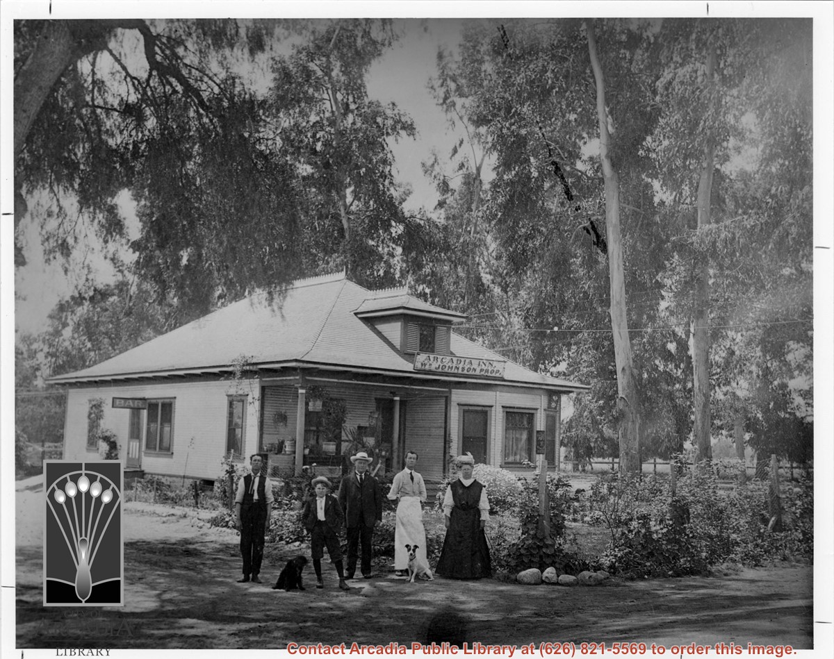
Almost square building standing under tall Eucalyptus trees with sign across front reading: ARCADIA INN,WM. JOHNSON PROPRIETOR. According to information given to Sandy Snider at the Arboretum in a telephone interview with Vesta Reeves, this was known as Johnson's Inn and was on the SE corner of Santa Anita Avenue and Foothill Boulevard.
https://arcadiahistory.andornot.com/en/permalink/photographs549
- Date
- c.1905-1910
1 image
- Date
- c.1905-1910
- Subjects
- Arcadia Inn
- Physical Description
- 8x10 b&w
- ID
- 545
- Collection
- Photographs
Images
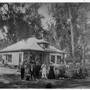
American Lutheran Church, then at 1424 S. Baldwin, which was later home of Serbian Orthodox Church. Building was dedicated Nov. 12, 1939, enlarged in 1945 and sold in 1963 to Serbian Orthodox, when Lutheran congregation's new church was built on Duarte Road.
https://arcadiahistory.andornot.com/en/permalink/photographs235
- Date
- c.1948
1 image

An 81-year-old West Covina man, Hao Liang, was struck and killed by a car when he was walking across Santa Anita Avenue, south of Duarte Road, last Wednesday, December 18, approximately 5:36 PM, at La Sierra Drive. The driver was a 36-year-old Monterey Park woman.
https://arcadiahistory.andornot.com/en/permalink/newspaper33710
- Newspaper
- Pasadena Star News
- Date
- December 20, 2013
- Pages
- p. A4
- Subjects
- Deaths
- Liang, Hao
- Item ID
- 33906AN
- Collection
- Newspaper Index