A 55-year-old Arcadia man was shot dead at Chantry Flat Campground on April 28, 2011. His name has not been released. He died at Huntington Hospital.
https://arcadiahistory.andornot.com/en/permalink/newspaper32387
- Newspaper
- Pasadena Star News
- Date
- April 30, 2011
- Pages
- p. A3
- Item ID
- 32585AN
- Collection
- Newspaper Index
The Adams' Pack Station, owned by Deb Burgess, in the Chantry Flat area, 3 miles up a road starting from the top of Santa Anita Avenue in Arcadia, fights to remain open as it faces costly upgrades required by the Los Angeles County Health Department. Forest authorities want it to remain a historic landmark, which would limit the amount and types of renovations that can be done.
https://arcadiahistory.andornot.com/en/permalink/newspaper31930
- Newspaper
- Pasadena Star News
- Date
- March 14, 2010
- Pages
- p. A1
- Item ID
- 32127AN
- Collection
- Newspaper Index
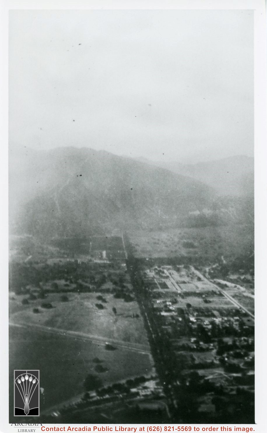
Aerial view north up Santa Anita Avenue. Note Chantry Flats Road on mountain near right side of photo. This view was taken from just south of Huntington Drive. This image belongs to Arcadia Historical Society.
https://arcadiahistory.andornot.com/en/permalink/photographs587
- Date
- November 1926
1 image
- Date
- November 1926
- Physical Description
- 6x10 vertical
- ID
- 583
- Collection
- Photographs
Images
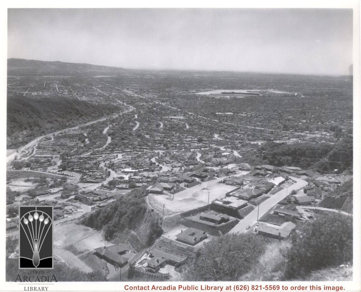
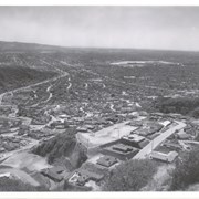
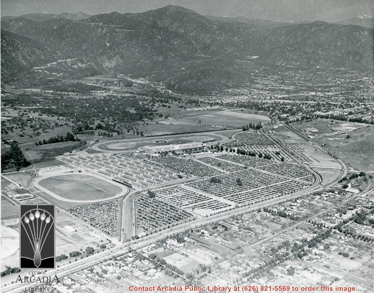
Aerial view south from Chantry Flats Road over the still-developing upper Highlands section of Arcadia. View is across Arcadia toward the Puente Hills. Santa Anita Park Race Track is seen in the center. Santa Anita Wash is seen on extreme left.
https://arcadiahistory.andornot.com/en/permalink/photographs955
- Date
- c.1965
1 image
- Date
- c.1965
- Subjects
- Aerial Photo Collection
- Aerial views
- Arcadia(City)-History-1960-1969
- Chantry Flats Road
- Santa Anita Wash
- Physical Description
- 8x10 b&w
- ID
- 949
- Collection
- Photographs
Images
Aerial view toward NE. Main thoroughfare cutting across east to west with young trees planted on north side, is Huntington Drive. Main race track at Santa Anita is seen almost directly in center of photo, with Club House on side closest to camera. The smaller oval near left edge of photo was a training track belonging to Santa Anita which was removed for the Fashion Park. The Chantry Flats Road up to Santa Anita Canyon is clearly seen as it zig-zags around San Gabriel Mountains. This photo belongs to the Huntington Library. It is shown here for research only.
https://arcadiahistory.andornot.com/en/permalink/photographs629
- Date
- c. 1940s
1 image
- Date
- c. 1940s
- Subjects
- San Gabriel Mountains
- Santa Anita Park-1934-1942
- Chantry Flats Road
- Huntington Drive
- Fashion Park
- Physical Description
- 8x10 b&w
- ID
- 625
- Collection
- Photographs
Images
Aerial view toward north from a position south of Huntington Drive near intersection with Baldwin Avenue. It shows Santa Anita Fashion Park (currently known as Westfield Santa Anita Shopping Mall) developed by and on property owned by Santa Anita Consolidated. The Santa Anita Park Race Track and club house can be seen in center of photo. The straight white line about one inch above the club house roof is 210 Foothill Freeway. Chantry Flats road can be seen going up into San Gabriel Mountains in distance.
https://arcadiahistory.andornot.com/en/permalink/photographs646
- Date
- c. 1975
1 image
- Date
- c. 1975
- Subjects
- Aerial Photo Collection
- Aerial views
- 210 Foothill Freeway
- Chantry Flats Road
- Malls
- San Gabriel Mountains
- Santa Anita Park-1945-1980
- Santa Anita Fashion Park
- Westfield Santa Anita Shopping Mall
- Physical Description
- 8x10 b&w
- ID
- 642
- Collection
- Photographs
Images


Arcadia has new hiking shuttle. U.S. Forest Service starts bus service to Chantry Flat trails from Arcadia Gold Line station. The shuttle goes to Chantry Flat Road, an area that connects to trails that lead to Sturtevant Falls, Hermit Falls, and historic Mount Wilson. The shuttle will run the next three weekends. Plans to make it permanent have not been formulated. See also Pasadena Star News, September 21, 2016, p. A7.
https://arcadiahistory.andornot.com/en/permalink/newspaper34675
- Newspaper
- Pasadena Star News
- Date
- September 20, 2016
- Pages
- p. A1, A6
- Subjects
- Angeles National Forest
- Bus
- Chantry Flat
- Hiking
- San Gabriel Mountains
- Shuttle Service
- United States Forest Service
- Item ID
- 34867AN
- Collection
- Newspaper Index
A cabin is lost, but memories endure. Greg Vanni of Arcadia, had a cabin among the 80 historic Chantry Flat cabins in Big Santa Anita Canyon. It burned to its foundation in the Bobcat Fire. It was a 350-foot cabin built in 1910 during "The Great Hiking Era," a time between the 1880s to the late 1930s in Southern California, when settlers from the city were drawn to the San Gabriel Mountains looking for adventure. The historic Adams Pack Station survived the fire.
https://arcadiahistory.andornot.com/en/permalink/newspaper35859
- Newspaper
- Pasadena Star News
- Date
- November 22, 2020
- Pages
- p. A4, A5
- Collection
- Newspaper Index
Chantry Flat and other areas of the Angeles National Forest have been closed to the public due to extreme fire conditions.
https://arcadiahistory.andornot.com/en/permalink/newspaper29146
- Newspaper
- Pasadena Star News
- Date
- September 25, 2004
- Pages
- p. A1
- Subjects
- Angeles National Forest
- Closures
- Chantry Flat
- Item ID
- 29331AN
- Collection
- Newspaper Index
Chantry Flat is still closed as a public area gets reconstructed and Arcadia's Public Works Department handles other road improvements.
https://arcadiahistory.andornot.com/en/permalink/newspaper29337
- Newspaper
- Pasadena Star News
- Date
- December 20, 2004
- Pages
- p. A1
- Item ID
- 29521AN
- Collection
- Newspaper Index
Chantry Flat Mule Pack Station owner Kim Kelley has been given a reprieve to continue operating her business in the Angeles National Forest.
https://arcadiahistory.andornot.com/en/permalink/newspaper20402
- Newspaper
- Pasadena Star News
- Date
- March 8, 2001
- Pages
- p. A1 w/photo
- Item ID
- 20636AN
- Collection
- Newspaper Index
Chantry Flat Road, also known as Santa Anita Canyon Road, will reopen to the public on Wednesday, April 16, despite unfinished repairs. Fire in the Santa Anita Canyon had forced a 6-month closure of the road.
https://arcadiahistory.andornot.com/en/permalink/newspaper31236
- Newspaper
- Arcadia Weekly
- Date
- April 17, 2003
- Pages
- p. 19
- Item ID
- 31429AN
- Collection
- Newspaper Index
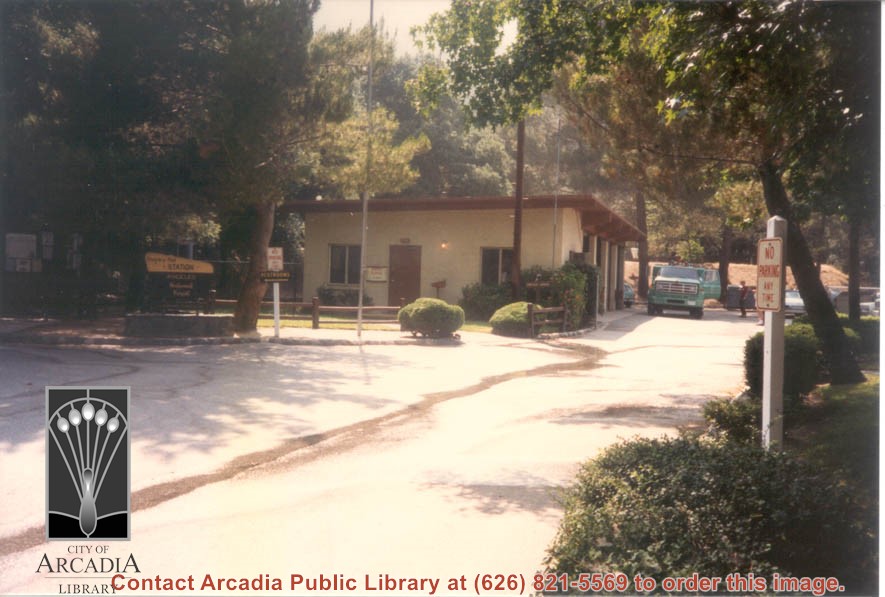
Chantry Flat Station, part of Angeles National Forest. Ranger trucks are to the right of station.
https://arcadiahistory.andornot.com/en/permalink/photographs1209
- Date
- July 8, 1987
1 image
The City Council approved funding for a new guardrail along Santa Anita Canyon Road, where a motorist drove over a mountainside last year. Federal funds will cover 90% of the new guardrail costs, and the new guardrail could be in place as early as spring.
https://arcadiahistory.andornot.com/en/permalink/newspaper3393
- Newspaper
- Arcadia Tribune
- Date
- December 23, 1990
- Pages
- p. A-1
- Subjects
- Streets - Chantry Flat Road
- Item ID
- 3283AN
- Collection
- Newspaper Index
Damage saps fun from Angeles forest. Angeles National Forest's Chantry Flat Road remains closed after suffering damage from the 2020 Bobcat fire and subsequent fires. Storms and fires force closure of trails, roads and campgrounds, some for years. The forest's second-most visited area, Chantry Flat, in the section north of Arcadia, Monrovia and Sierra Madre, has been closed since the start of the pandemic in March 2020. A sign in Arcadia (photo) advises motorists of the Chantry Flat Road closure.
https://arcadiahistory.andornot.com/en/permalink/newspaper36507
- Newspaper
- Pasadena Star News
- Date
- July 18, 2023
- Pages
- p. A1, A6
- Collection
- Newspaper Index
Due to high temperatures and gusty winds the gate to Chantry Flat Road and the Angeles National Forest will be closed over the weekend.
https://arcadiahistory.andornot.com/en/permalink/newspaper26612
- Newspaper
- Pasadena Star News
- Date
- October 23, 2003
- Pages
- p. A2
- Subjects
- Chantry Flat
- Angeles National Forest
- Winds
- Item ID
- 26812AN
- Collection
- Newspaper Index
Kim Kelley is resolving her permit problems with the Forest Service and looks forward to serving her customers.
https://arcadiahistory.andornot.com/en/permalink/newspaper20403
- Newspaper
- Pasadena Star News
- Date
- March 12, 2001
- Pages
- p. A1 w/photo
- Item ID
- 20637AN
- Collection
- Newspaper Index
Kim Kelley, owner of the Adams pack station near Chantry Flat, has decided to sell the historic station for financial reasons. The heavily damaged roads to Big Santa Anita Canyon have hurt her business.
https://arcadiahistory.andornot.com/en/permalink/newspaper29791
- Newspaper
- Pasadena Star News
- Date
- November 25, 2005
- Pages
- p. A1, A8
- Item ID
- 29976AN
- Collection
- Newspaper Index
Native American tribes seek expansion of national monument with more than 100,000 acres. Indigenous leaders say more parts of the San Gabriel Mountains are "sacred lands." They are calling on the Biden administration to go further in protecting the San Gabriel Mountains National Monument.
https://arcadiahistory.andornot.com/en/permalink/newspaper36598
- Newspaper
- Pasadena Star News
- Date
- December 1, 2023
- Pages
- p. A1, A4
- Subjects
- Angeles National Forest
- Antiquities Act
- Biden, Joe (President of the United States of America)
- Chantry Flat
- Desert Cahuilla Indians
- Fernandeno Tataviam Band of Mission Indians
- Forests
- Legislation
- Pit River Nation
- San Gabriel Mountains National Monument
- Collection
- Newspaper Index
Nearly all of region's national forest areas, including the Angeles, Los Padres, San Bernardino and Cleveland national forests, reopened yesterday, one week after the expiration of the California regional closure. The forests also lowered their fire danger level from critical to extreme, according to the U.S. Forest Service. The closure order was issued August 31 in response to statewide wildfires. Although the majority of the Angeles National Forest will reopen, a significant part will remain closed due to the 2020 Bobcat fire. The closure order for Angeles National Forest has been in place since September 2020 and remains in effect until April, to allow for affected areas to recover from the 100,000-plus-acre Bobcat Fire. Still closed are Chantry Flat Picnic Area and Buckhorn Campground.
https://arcadiahistory.andornot.com/en/permalink/newspaper36052
- Newspaper
- Pasadena Star News
- Date
- September 24, 2021
- Pages
- p. A3
- Subjects
- Angeles National Forest
- Bobcat Fire
- Buckhorn Campground
- Chantry Flat Picnic Area
- U.S. Forest Service
- Wildfires
- Collection
- Newspaper Index