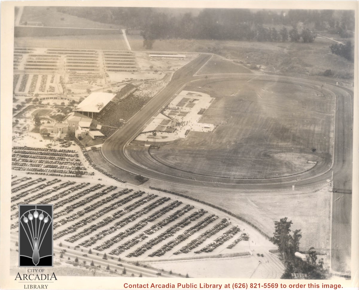
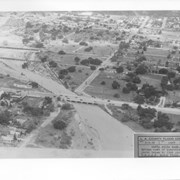
Aerial view looking west over Santa Anita Park. Photo was taken from about over intersection of Colorado Place and Huntington Drive. Note area that was to become Los Angeles County Arboretum across top of photo. Note an open Grandstand has been added to the west of original covered one. There is a small dirigible in lower right corner carrying a sign that seems to read:modern motel. Present Baldwin Avenue would run where road in this photo is seen parallel to top of photo.
https://arcadiahistory.andornot.com/en/permalink/photographs983
- Date
- December 28, 1935
1 image
- Date
- December 28, 1935
- Physical Description
- 8x10 b&w
- ID
- 975
- Collection
- Photographs
Images
Aerial view of what appears to be either an informal horse show or possible horse sale with a great number of people in attendance. The location has been identified as near intersection of Las Tunas Drive and (with what seem to be railroad tracks in center) Temple City Boulevard. The building (we see only roof) in the lower left corner is Vernon's Pharmacy. The letters VGS can be seen over front entry. There are probably about 100 autos parked nearby. (There is another photo of this event, #539.)
https://arcadiahistory.andornot.com/en/permalink/photographs647
- Date
- c. early 1930's
1 image


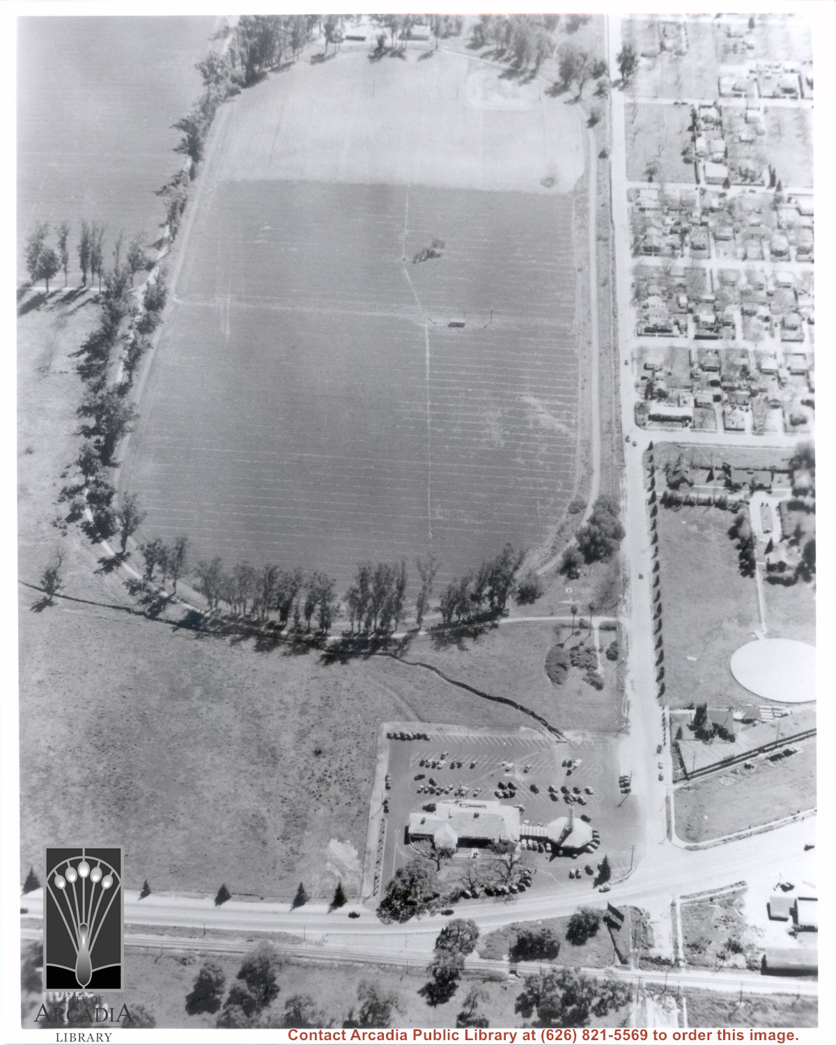
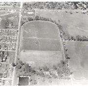
Santa Fe Railroad tracks cut diagonally across photo from east to west. Huntington Drive bisects photo from east to west approximately at center of photo. Arcadia County Park appears in lower left corner, showing baseball diamond. Santa Anita Wash is shown on right side of photo.
https://arcadiahistory.andornot.com/en/permalink/photographs625
- Date
- c. early 1950's
1 image
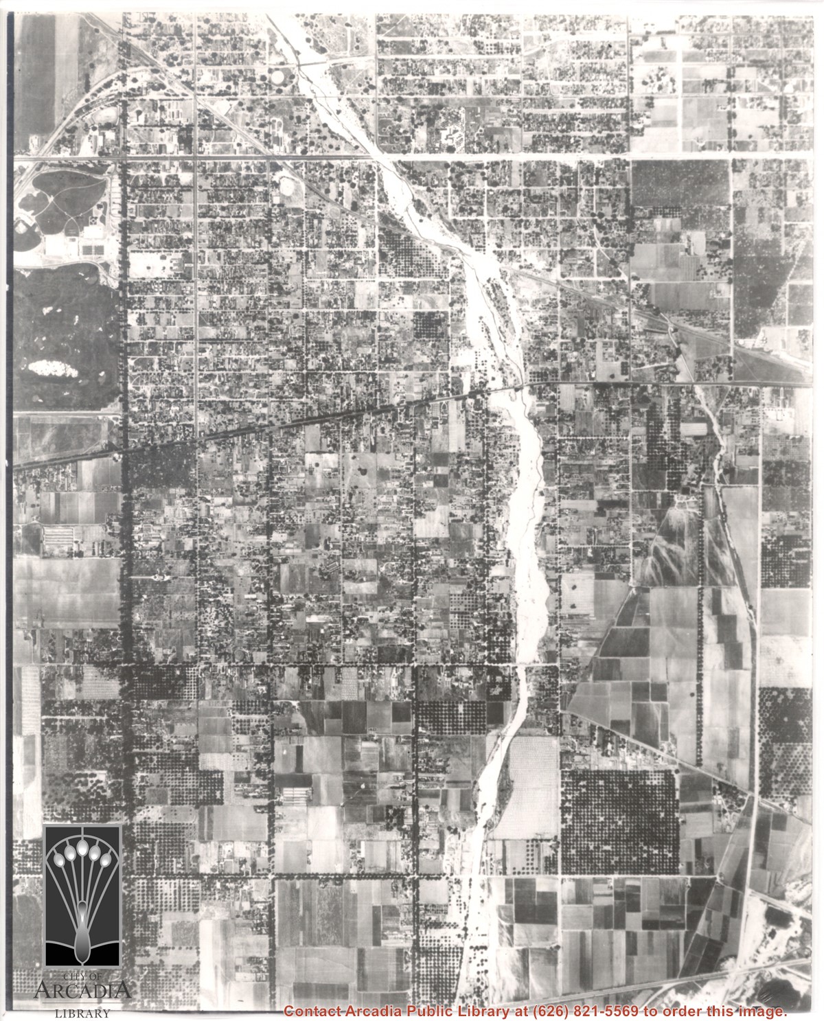
Most prominent physical feature is Santa Anita Wash running north to south almost in center of photo, just above center(?). Santa Anita Avenue is north/south street, dark with trees approximately one inch from left edge of photo. Arcadia County Park is at upper left edge of photo with baseball diamond showing.
https://arcadiahistory.andornot.com/en/permalink/photographs622
- Date
- June 5, 1938
1 image
- Date
- June 5, 1938
- Subjects
- Aerial Photo Collection
- Aerial views
- Arcadia County Park
- Duarte Road
- Santa Anita Avenue
- Santa Anita Wash
- Physical Description
- 8x10 b&w
- ID
- 618
- Collection
- Photographs
Images
Aerial view showing Eaton's Santa Anita in foreground, looking south from Colorado Boulevard and Michillinda Avenue. Lucky Baldwin's one mile training track built in 1876 is visible with stud barn buildings on south end of track.
https://arcadiahistory.andornot.com/en/permalink/photographs1541
- Date
- March 7, 1940
1 image
- Date
- March 7, 1940
- Subjects
- Aerial Photo Collection
- Aerial views
- Baldwin, Elias J. "Lucky" - Horses and horse racing
- Colorado Boulevard
- Michillinda Avenue
- Rancho Santa Anita
- Restaurants, bars, etc - Eaton's Santa Anita Hotel and Restaurant
- Physical Description
- 8x10 b&w
- ID
- 1525
- Collection
- Photographs
Images
Aerial view of Rancho Santa Anita taken above Dairy, looking north, with 5,000,000 gallon reservoir in lower left, and Baldwin's one mile training track built in 1876 with stud barn buildings on south end of track. Eaton's Santa Anita at Colorado Boulevard and Michillinda Avenue just visible at top of photo.
https://arcadiahistory.andornot.com/en/permalink/photographs1542
- Date
- March 7, 1940
1 image
- Date
- March 7, 1940
- Subjects
- Aerial Photo Collection
- Aerial views
- Baldwin, Elias J. "Lucky" - Horses and horse racing
- Colorado Boulevard
- Michillinda Avenue
- Rancho Santa Anita
- Restaurants, bars, etc - Eaton's Santa Anita Hotel and Restaurant
- Physical Description
- 8x10 b&w
- ID
- 1526
- Collection
- Photographs
Images

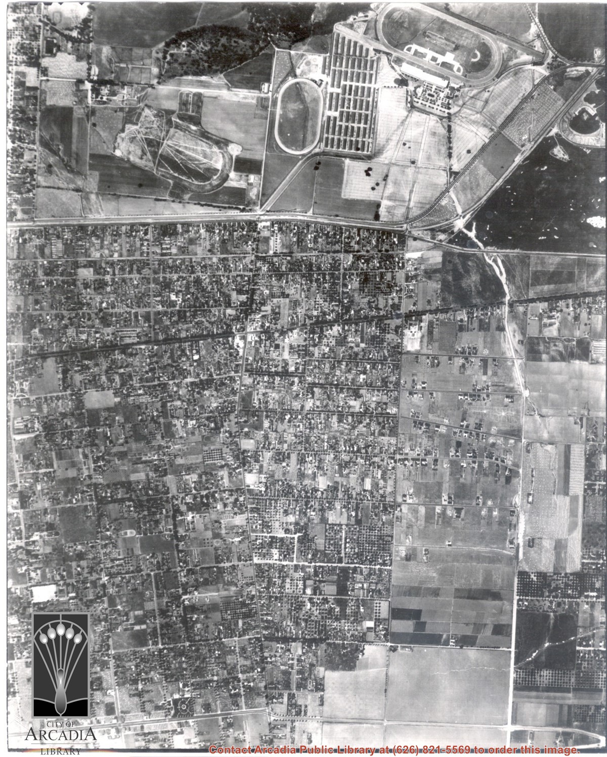
Dark, tree-lined street completely bisecting photo from west to east just above, is Duarte Road. Santa Anita Park Race Track is at upper right edge of photo. Smaller oval nearby is a training track. The incomplete oval in upper left is the race track that Anita Baldwin and Joe Smoot attempted to build in 1933 but abandoned the project. Huntington Drive and Colorado Place form a "y" just east of Santa Anita Park Race Track. Note grove of olive trees on land where City Hall is located today (240 W. Huntington Drive, Arcadia). Baseball diamond in upper right corner of photo, just below the convergence of the "y" is at Arcadia County Park. Corrected description as of 11/04/2008.
https://arcadiahistory.andornot.com/en/permalink/photographs621
- Date
- June 5, 1938
1 image
- Date
- June 5, 1938
- Subjects
- Aerial Photo Collection
- Aerial views
- Colorado Place
- Duarte Road
- Los Angeles Jockey Club
- Santa Anita Park-1934-1942
- Physical Description
- 8x10 b&w
- ID
- 617
- Collection
- Photographs
Images
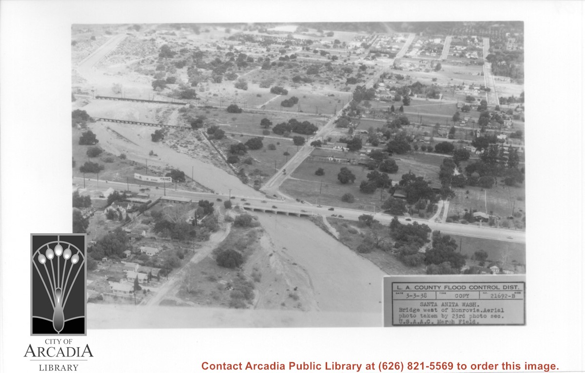
Aerial view looking north over flooded Santa Anita Wash looking upstream. Street cutting across photo closest to bottom is Huntington Drive. The next crossing upstream carries Santa Fe Railroad track. The last crossing that is clearly visible is Pacific Electric Railroad bridge. North/south street crossing Huntington Drive nearest wash would be Fifth Avenue. Foothill Boulevard is just barely visible near top of photo.
https://arcadiahistory.andornot.com/en/permalink/photographs815
- Date
- March 3, 1938
1 image
- Date
- March 3, 1938
- Subjects
- Aerial Photo Collection
- Aerial views
- Fifth Avenue
- Flood control
- Foothill Boulevard
- Huntington Drive
- Railroads
- Santa Anita Wash
- Physical Description
- 5x7 b&w
- ID
- 809
- Collection
- Photographs
Images
Santa Anita Park Race Track just right of center at south edge of photo. Oval to the left of Santa Anita Park Race Track was training track which was removed to make room for Santa Anita Fashion Park (currently Westfield Santa Anita Shopping Mall). Street just to left of training track is Baldwin Avenue. Huntington Drive and Colorado Place form a "y" just east of Santa Anita Park Race Track. Along both can be noticed the conifer trees planted a few years earlier. Street completely bisecting photo just below center is Foothill Boulevard, next one is Orange Grove Avenue. Santa Anita Avenue is partially in view on right edge of photo. Oval on extreme lower left side of photo is old Baldwin training track. Baseball diamond in lower right corner is at Arcadia County Park. Scale: 1"=660'
https://arcadiahistory.andornot.com/en/permalink/photographs620
- Date
- June 5, 1938
1 image
- Date
- June 5, 1938
- Subjects
- Aerial Photo Collection
- Aerial views
- Baldwin Avenue
- Colorado Boulevard
- Colorado Place
- Colorado Street
- Foothill Boulevard
- Huntington Drive
- Orange Grove Avenue
- Santa Anita Fashion Park (later known as Westfield Santa Anita)
- Santa Anita Park-1934-1942
- Physical Description
- 8x10 b&w
- ID
- 616
- Collection
- Photographs
Images

