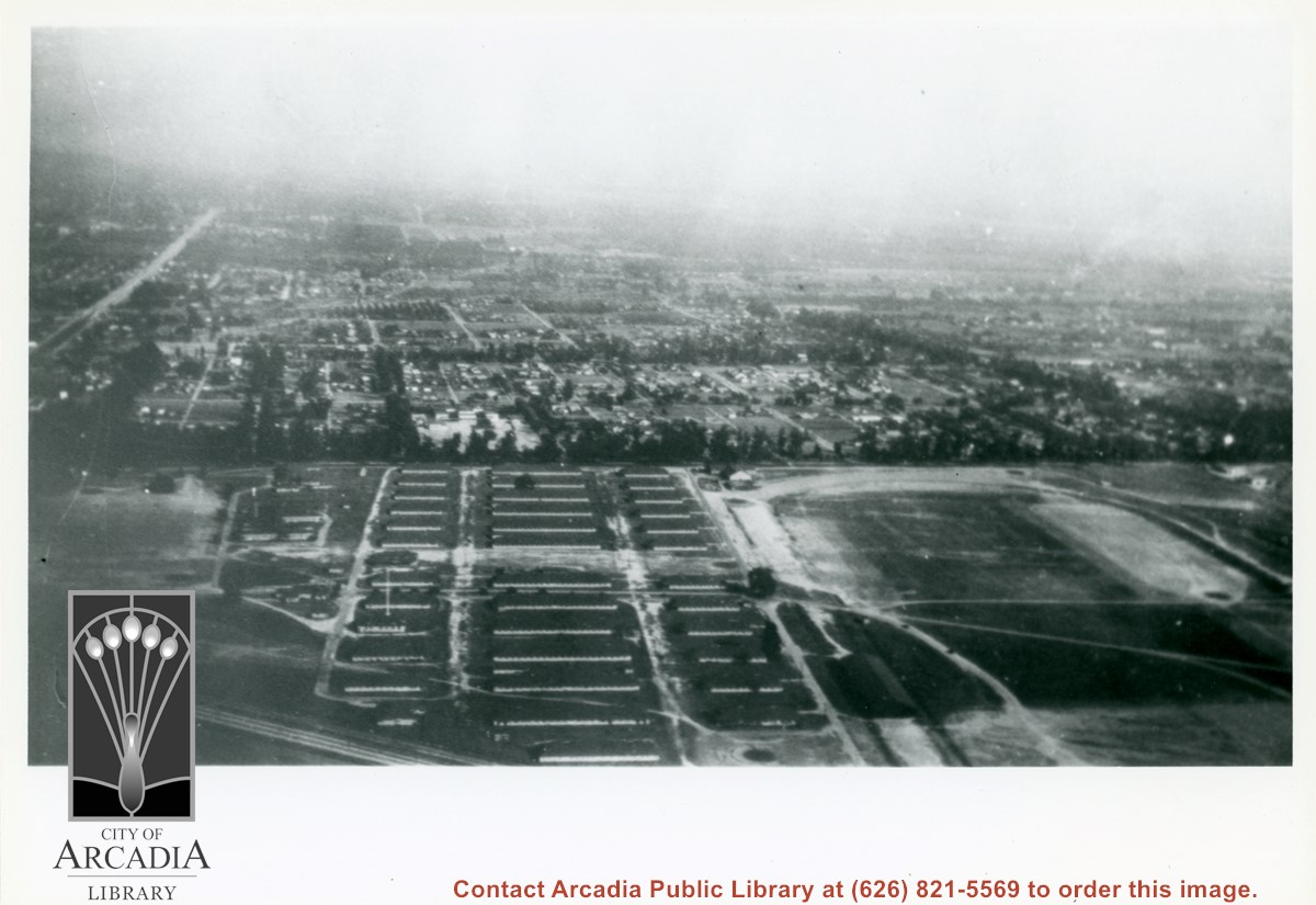
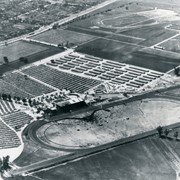
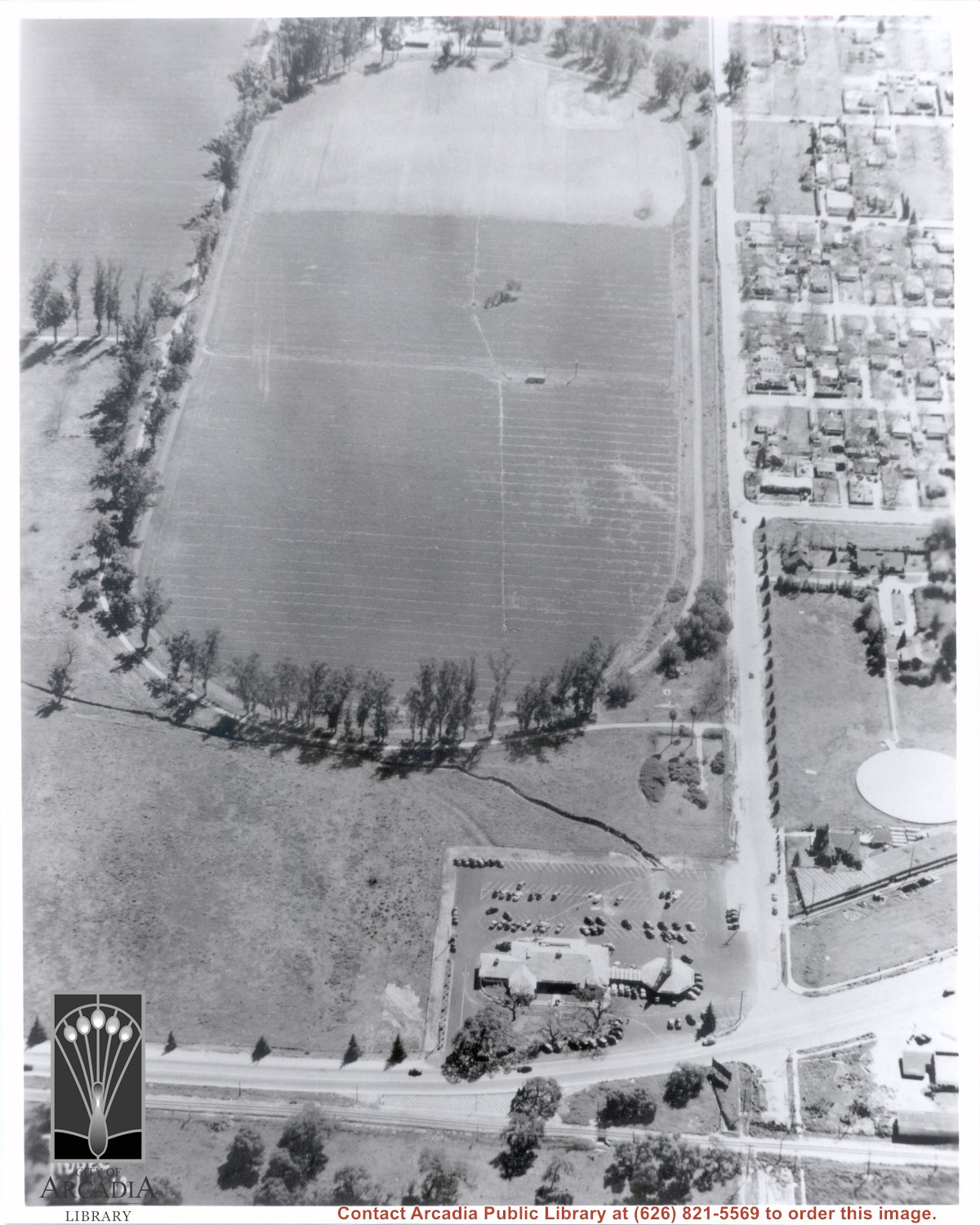
Looking east over barracks and main building at Ross Field. Tree-lined street cutting across photo at far side of field is Santa Anita Avenue. The oval of the race track built by E.J."Lucky" Baldwin and which opened in 1907 can clearly be seen on right. Broad E/W street seen on far left is Huntington Drive.
https://arcadiahistory.andornot.com/en/permalink/photographs867
- Date
- c.1928
1 image
Aerial view looking east across Santa Anita Park taken from a position just west of Baldwin Avenue, which is seen at bottom of photo. Huntington Drive appears exactly in center of photo just east of race track. The 210 Foothill Freeway enters area in upper right portion of picture and exits at left side in upper left portion.
https://arcadiahistory.andornot.com/en/permalink/photographs996
- Date
- c.1979
1 image
- Date
- c.1979
- Subjects
- Aerial Photo Collection
- Aerial views
- 210 Foothill Freeway
- Huntington Drive
- Santa Anita Park-1945-1980
- Physical Description
- 8x10 b&w
- ID
- 989
- Collection
- Photographs
Images


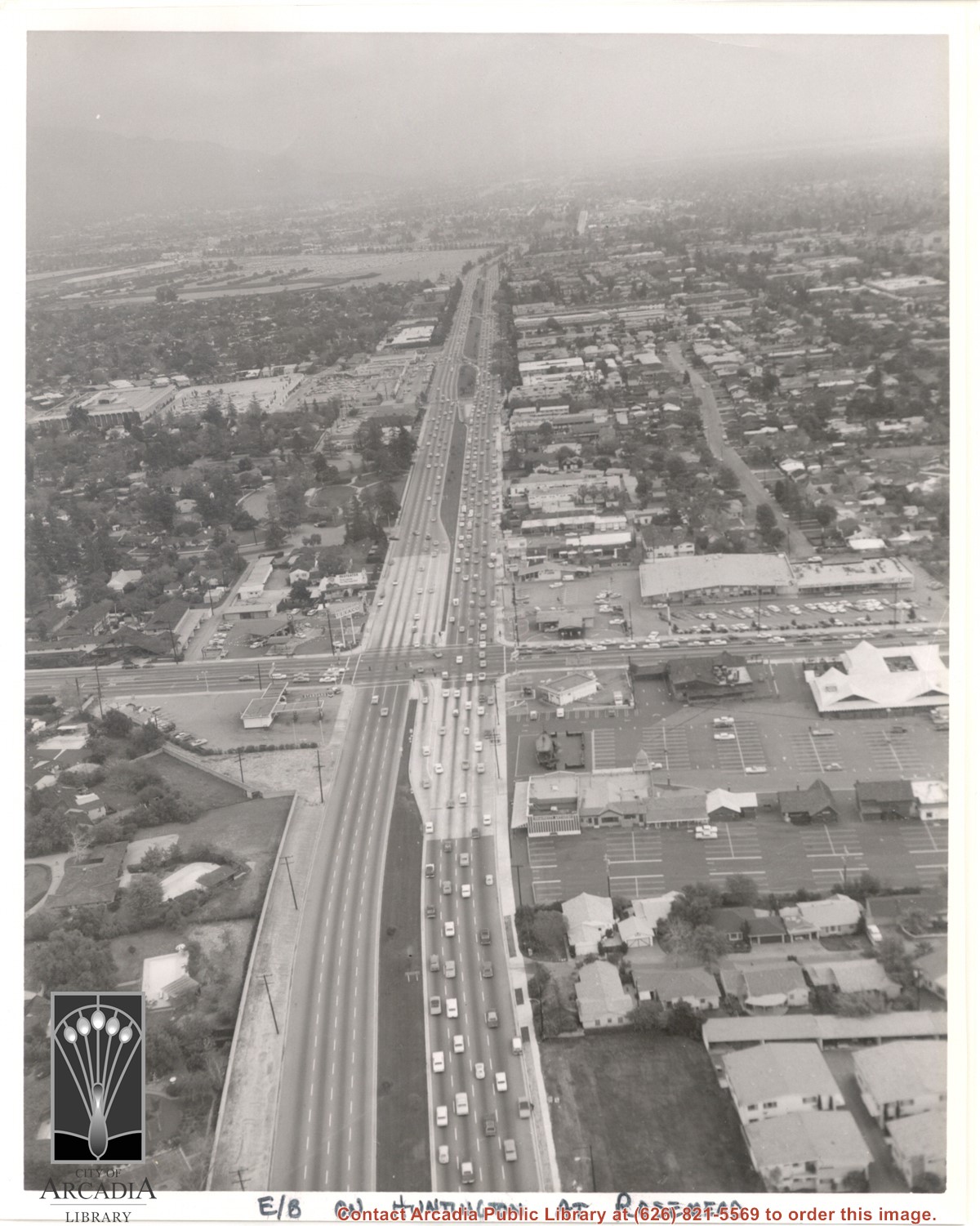
Aerial view east on Huntington Drive toward Arcadia from a position just west of Rosemead Boulevard. El Rancho Shopping Center and May Company Department Store can be seen as the business complex on the north side of Huntington Drive one block east of Rosemead Boulevard. Santa Anita Park Race Track can be seen on the left in upper portion of photo.
https://arcadiahistory.andornot.com/en/permalink/photographs637
- Date
- c.1970
1 image
- Date
- c.1970
- Subjects
- Aerial Photo Collection
- Aerial views
- El Rancho Shopping District
- Huntington Drive
- May Company Department Store
- Santa Anita Park-1945-1980
- Physical Description
- 8x10 b&w
- ID
- 633
- Collection
- Photographs
Images
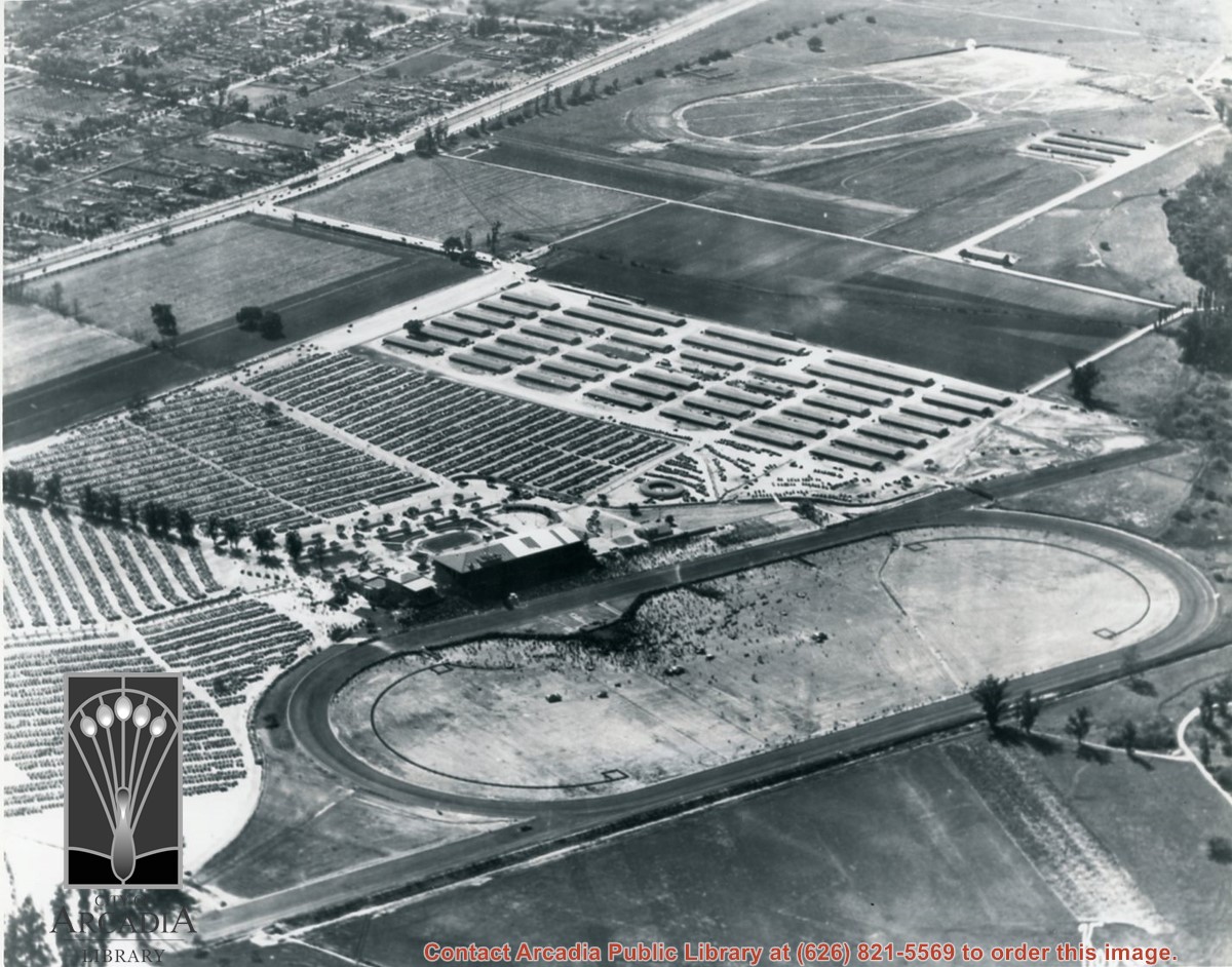
Aerial view taken looking southeast from position about over present Arboretum. Photo shows Santa Anita Park, probably in opening season. Present City Hall sits in area just beyond cars parked at east end of track. Part of oval of old Santa Anita track built by Elias J. "Lucky" Baldwin is seen in upper portion of photo, in area that is now Arcadia County Park. Duarte Road is seen crossing photo in upper right corner. Present Arcadia County Park area is in this photo, bordered on the north by Pacific Electric Railroad tracks. A train has just brought a group to the races and they are seen walking in center of photo. White square seen near right side, is slab left from hangars when U.S. Army Balloon School occupied this site, 1917-1927.
https://arcadiahistory.andornot.com/en/permalink/photographs986
- Date
- c.1934 racing season
1 image
- Date
- c.1934 racing season
- Subjects
- Aerial Photo Collection
- Aerial views
- Arcadia County Park
- Duarte Road
- Race tracks
- Railroads
- Santa Anita Park-1934-1942
- Santa Anita Park-1907-1912
- Physical Description
- 8x10 b&w
- ID
- 978
- Collection
- Photographs
Images


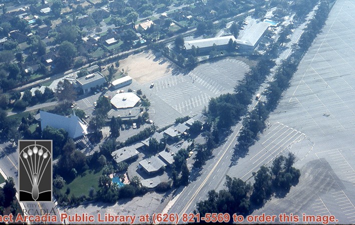
Aerial view, of Santa Anita Park Race Track in the upper left quadrant (address is 285 West Huntington Drive) and the white A-Frame roof of Santa Anita Church (address is 226 West Colorado Boulevard) in the lower right quadrant. A six-sided, hexagon building seen to the left of Santa Anita Church, is the Fireside Room and Fellowship Hall, which is part of the Santa Anita Church. Any use of this image must be credited "Photograph by David Stevens. Copyright David Stevens."
https://arcadiahistory.andornot.com/en/permalink/photographs2416
- Date
- 1990?
1 image
- Date
- 1990?
- Subjects
- Aerial Photo Collection
- Aerial views
- David Stevens Collection
- Santa Anita Church
- Santa Anita Park
- Physical Description
- color image, digital, see i:images
- ID
- 2274
- Collection
- Photographs
Images

Aerial view looking west across Santa Anita Park from a position about Santa Anita Avenue just north of Huntington Drive. In the upper right portion of the photo can be seen the extensive earthwork done for the track Anita Baldwin and Joe Smoot planned to build. That vast area now is entirely built with homes and apartments and is called Santa Anita Village. Present-day Baldwin Avenue would follow the line shown by the Ranch Road bisecting the photo from right to left just east of the track abandoned by Anita Baldwin and Joe Smoot.
https://arcadiahistory.andornot.com/en/permalink/photographs985
- Date
- c.1934
1 image
Aerial view from position above Huntington Drive near Holly Avenue intersection looking north over Santa Anita Park. Colorado Place and Huntington Drive are seen coming together at right side of photo. Note how small the deodar (?) trees planted along Huntington Drive and Colorado Place are. Row of trees seen in center of photo were apparently left from Ranch days and were later removed.
https://arcadiahistory.andornot.com/en/permalink/photographs984
- Date
- December 1, 1935
1 image
- Date
- December 1, 1935
- Subjects
- Aerial Photo Collection
- Aerial views
- Colorado Place
- Huntington Drive
- Santa Anita Park-1934-1942
- Physical Description
- 8x10 b&w
- ID
- 976
- Collection
- Photographs
Images

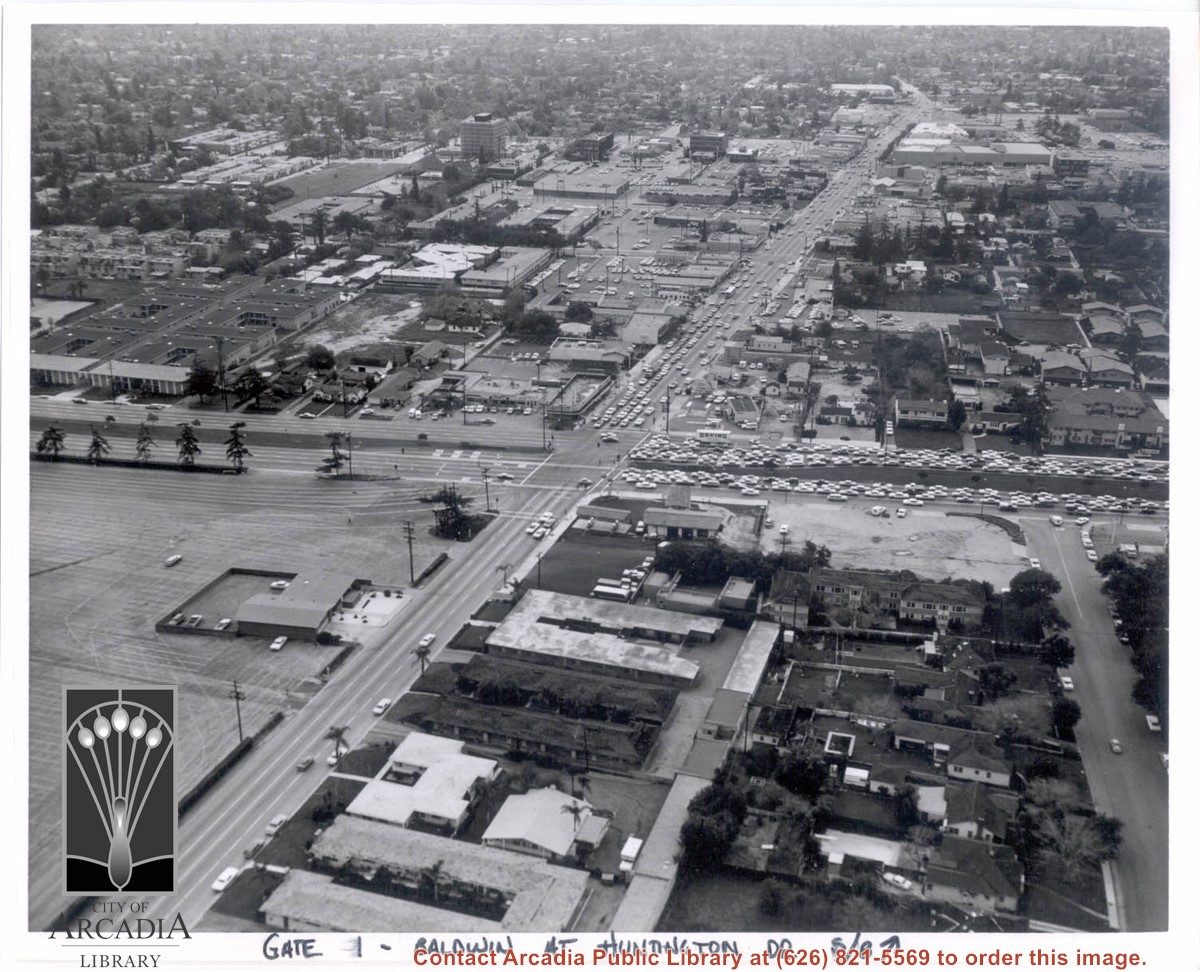
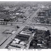
Aerial view south on Baldwin Avenue. From position just north of Huntington Drive (during racing season) showing great number of cars coming east on Huntington Drive to races through Gate #1. One building in Santa Anita Park Race Track parking lot is Fire Station at 630 S. Baldwin Avenue. Duarte Road is distantly seen in upper portion of photo, about 1 1/4 in. from top of photo. The multi-storied Medical Building seen is at 612 W. Duarte Road.
https://arcadiahistory.andornot.com/en/permalink/photographs636
- Date
- c.1970
1 image
- Date
- c.1970
- Subjects
- Aerial Photo Collection
- Aerial views
- Arcadia Fire Department
- Baldwin Avenue
- Duarte Road
- Huntington Drive
- Santa Anita Park-1945-1980
- Physical Description
- 8x10 b&w
- ID
- 632
- Collection
- Photographs
Images
Aerial view showing Eaton's Santa Anita in foreground, looking south from Colorado Boulevard and Michillinda Avenue. Lucky Baldwin's one mile training track built in 1876 is visible with stud barn buildings on south end of track.
https://arcadiahistory.andornot.com/en/permalink/photographs1541
- Date
- March 7, 1940
1 image
- Date
- March 7, 1940
- Subjects
- Aerial Photo Collection
- Aerial views
- Baldwin, Elias J. "Lucky" - Horses and horse racing
- Colorado Boulevard
- Michillinda Avenue
- Rancho Santa Anita
- Restaurants, bars, etc - Eaton's Santa Anita Hotel and Restaurant
- Physical Description
- 8x10 b&w
- ID
- 1525
- Collection
- Photographs
Images
Aerial view of Rancho Santa Anita taken above Dairy, looking north, with 5,000,000 gallon reservoir in lower left, and Baldwin's one mile training track built in 1876 with stud barn buildings on south end of track. Eaton's Santa Anita at Colorado Boulevard and Michillinda Avenue just visible at top of photo.
https://arcadiahistory.andornot.com/en/permalink/photographs1542
- Date
- March 7, 1940
1 image
- Date
- March 7, 1940
- Subjects
- Aerial Photo Collection
- Aerial views
- Baldwin, Elias J. "Lucky" - Horses and horse racing
- Colorado Boulevard
- Michillinda Avenue
- Rancho Santa Anita
- Restaurants, bars, etc - Eaton's Santa Anita Hotel and Restaurant
- Physical Description
- 8x10 b&w
- ID
- 1526
- Collection
- Photographs
Images

Aerial view looking north across Santa Anita Park from a position over Arcadia County Park. Large infield crowd is evident and all parking areas are filled. Arcadia Methodist Hospital shows in lower left part of photo and Arcadia Police facility is seen in lower right. The 210 Foothill Freeway cuts across photo near the top.
https://arcadiahistory.andornot.com/en/permalink/photographs995
- Date
- c.1979
1 image
- Date
- c.1979
- Subjects
- Aerial Photo Collection
- Aerial views
- 210 Foothill Freeway
- Arcadia Methodist Hospital
- Santa Anita Park-1945-1980
- Physical Description
- 8x10 b&w
- ID
- 988
- Collection
- Photographs
Images

Aerial view toward north from a position south of Huntington Drive near intersection with Baldwin Avenue. It shows Santa Anita Fashion Park (currently known as Westfield Santa Anita Shopping Mall) developed by and on property owned by Santa Anita Consolidated. The Santa Anita Park Race Track and club house can be seen in center of photo. The straight white line about one inch above the club house roof is 210 Foothill Freeway. Chantry Flats road can be seen going up into San Gabriel Mountains in distance.
https://arcadiahistory.andornot.com/en/permalink/photographs646
- Date
- c. 1975
1 image
- Date
- c. 1975
- Subjects
- Aerial Photo Collection
- Aerial views
- 210 Foothill Freeway
- Chantry Flats Road
- Malls
- San Gabriel Mountains
- Santa Anita Park-1945-1980
- Santa Anita Fashion Park
- Westfield Santa Anita Shopping Mall
- Physical Description
- 8x10 b&w
- ID
- 642
- Collection
- Photographs
Images


Aerial view, of the white A-Frame roof of Santa Anita Church (address is 226 West Colorado Boulevard, Arcadia, California). A six-sided, hexagon building near Santa Anita Church is the Fireside Room and Fellowship Hall, which is part of the Santa Anita Church. Any use of this image must be credited "Photograph by David Stevens. Copyright David Stevens."
https://arcadiahistory.andornot.com/en/permalink/photographs2420
- Date
- 1990?
1 image
- Date
- 1990?
- Physical Description
- color image, digital, see i:images
- ID
- 2278
- Collection
- Photographs
Images
Michillinda Avenue is street running parallel to left edge of photo. Santa Anita Avenue is close to right edge of photo. Four tracks are in view. Left to right they would be: 1. Training track used by Elias J. "Lucky" Baldwin, 2. Aborted L. A. Jockey Club Track project of Anita Baldwin and Joe Smoot in 1933, 3. Small training track belonging to Santa Anita Park Race Track, and 4. Main track and grandstand of Santa Anita Park. Arcadia County Park is seen in lower right portion of photo.
https://arcadiahistory.andornot.com/en/permalink/photographs626
- Date
- June 5, 1938
1 image
- Date
- June 5, 1938
- Subjects
- Aerial Photo Collection
- Aerial views
- Los Angeles Jockey Club
- Michillinda Avenue
- Race tracks
- Santa Anita Park-1934-1942
- Physical Description
- 8x10 b&w
- ID
- 622
- Collection
- Photographs
Images
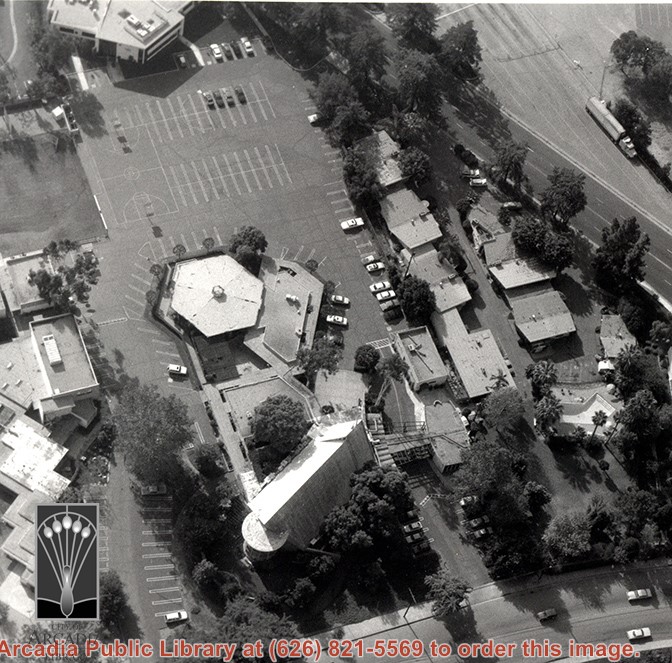
Aerial view, of the white A-Frame roof of Santa Anita Church (address is 226 West Colorado Boulevard, Arcadia, California). A six-sided, hexagon building near Santa Anita Church is the Fireside Room and Fellowship Hall, which is part of the Santa Anita Church. The church property goes all the way to Colorado Place (including "The Village Apartments," formerly the Frontier Motel, which the church purchased in 1972) and includes the parking lot and the building at the top of the photo, the Margaret Stevens Center. Any use of this image must be credited "Photograph by David Stevens. Copyright David Stevens."
https://arcadiahistory.andornot.com/en/permalink/photographs2421
- Date
- 1990?
1 image
- Date
- 1990?
- Physical Description
- color image, digital, see i:images
- ID
- 2279
- Collection
- Photographs
Images
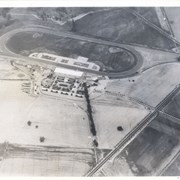
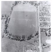
Aerial view toward the east taken from about over present Club House at Santa Anita Park Race Track. The main street running North/South is Santa Anita Avenue. View shows the oval of Elias J. "Lucky" Baldwin's race track in what is currently Arcadia County Park. The buildings would be barracks of Ross Field U.S. Army Balloon School. Duarte Road can be seen coming into photo at right edge of photo near intersection with Santa Anita Avenue. The broad street along left side would be Huntington Drive. Railroad tracks can be seen in lower left corner.
https://arcadiahistory.andornot.com/en/permalink/photographs635
- Date
- November 1929
1 image
- Date
- November 1929
- Subjects
- Aerial Photo Collection
- Aerial views
- Balloon School
- Huntington Drive
- Race tracks
- Railroads
- Santa Anita Avenue
- Physical Description
- 6x10 b&w
- ID
- 631
- Collection
- Photographs
Images

Aerial looking west from a position just east of First Avenue and just north of Wheeler Avenue. Large white barn-like roof is San Gabriel Valley Lumber Co. building. This later became the Sawmill Restaurant and in the early 1990's became Sports Rock Cafe. Directly opposite, is cleared land where Arcadia Public Library, Fire and Police were previously located. Today there is a Medical Building on the site (65 N. First Avenue). Santa Anita Park and parking lot are seen in the distance.
https://arcadiahistory.andornot.com/en/permalink/photographs999
- Date
- c.1977
1 image

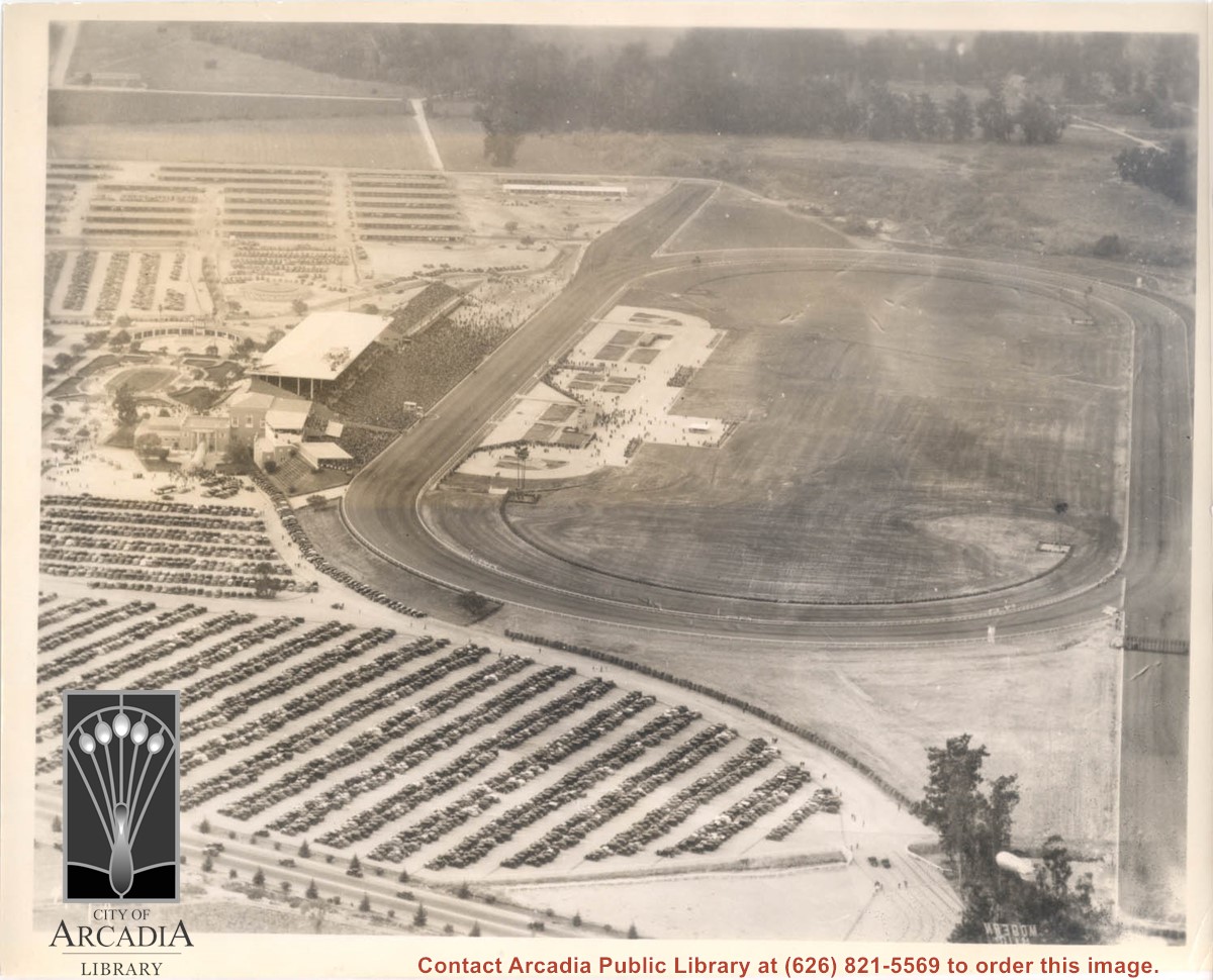
Aerial view looking west over Santa Anita Park. Photo was taken from about over intersection of Colorado Place and Huntington Drive. Note area that was to become Los Angeles County Arboretum across top of photo. Note an open Grandstand has been added to the west of original covered one. There is a small dirigible in lower right corner carrying a sign that seems to read:modern motel. Present Baldwin Avenue would run where road in this photo is seen parallel to top of photo.
https://arcadiahistory.andornot.com/en/permalink/photographs983
- Date
- December 28, 1935
1 image
- Date
- December 28, 1935
- Physical Description
- 8x10 b&w
- ID
- 975
- Collection
- Photographs
Images
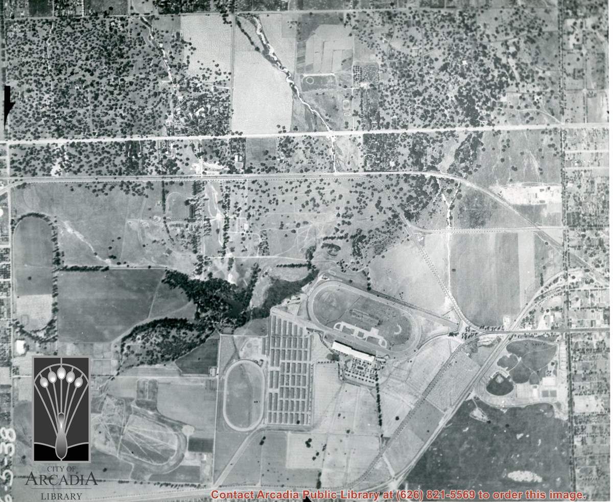
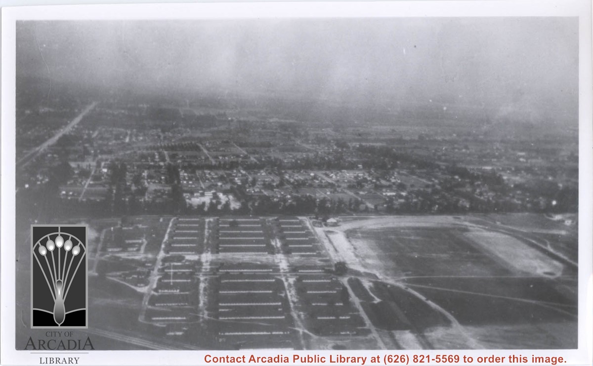
Aerial view south of Balloon School and surrounding part of valley. Large tree-lined street running from center of photo toward lower left edge of photo is Santa Anita. Tree-lined street coming in on right edge of photo about two inches from bottom of photo and intersecting Santa Anita, is Duarte Road. Note wash that at present is just west of Arcadia High School. Rio Hondo Wash runs east to west across middle of photo.
https://arcadiahistory.andornot.com/en/permalink/photographs153
- Date
- c.1918
1 image
- Date
- c.1918
- Subjects
- Aerial Photo Collection
- Aerial views
- U.S. Army Balloon School see Balloon School
- Balloon School
- Physical Description
- 8x10 b&w
- ID
- 152
- Collection
- Photographs
Images
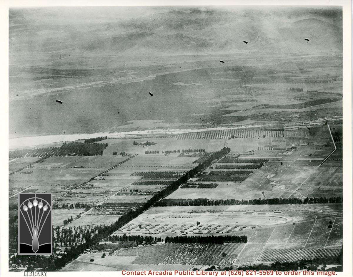
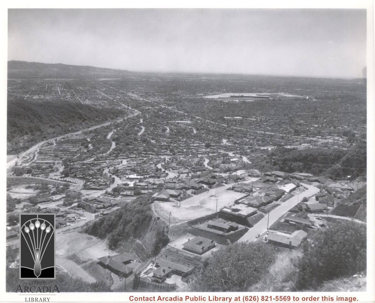
Aerial view south from Chantry Flats Road over the still-developing upper Highlands section of Arcadia. View is across Arcadia toward the Puente Hills. Santa Anita Park Race Track is seen in the center. Santa Anita Wash is seen on extreme left.
https://arcadiahistory.andornot.com/en/permalink/photographs955
- Date
- c.1965
1 image
- Date
- c.1965
- Subjects
- Aerial Photo Collection
- Aerial views
- Arcadia(City)-History-1960-1969
- Chantry Flats Road
- Santa Anita Wash
- Physical Description
- 8x10 b&w
- ID
- 949
- Collection
- Photographs
Images