Aerial view toward NE. Plane is over property of Charles W. Stewart (10 acres), and Jaspar Teague (10 acres), at 1320 S. Santa Anita Avenue, which is directly under the plane. Next street east is First Avenue, then Second Avenue, the Fourth Avenue. Reservoir is at corner of Valnett Avenue and Second Avenue and was owned by Walnut Grove Mutual Water Company (Valnett Avenue was first through street south of Duarte Road at this time and became Camino Real).
https://arcadiahistory.andornot.com/en/permalink/photographs644
- Date
- November 1929
1 image
- Date
- November 1929
- Subjects
- Aerial Photo Collection
- Aerial views
- Camino Real
- Duarte Road
- First Avenue
- Fourth Avenue
- Second Avenue
- Santa Anita Avenue (South)
- Stewart, Charles W.
- Teague, Jaspar
- Valnett Avenue
- Physical Description
- 6x10 b&w
- ID
- 640
- Collection
- Photographs
Images


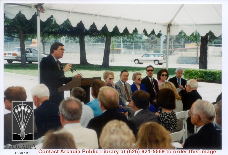
Groundbreaking ceremonies for the remodel/expansion project at Arcadia Public Library, 20 W. Duarte Road. Mayor Dennis Lojeski is addressing the audience. To the right are councilmembers Barbara Kuhn, Cheng Shang, Mary Young; City Mamager Bill Kelly; City Clerk June Alford; and, City Attorney Mike Miller.
https://arcadiahistory.andornot.com/en/permalink/photographs1500
- Date
- June, 1995
1 image
- Date
- June, 1995
- Subjects
- Arcadia Public Library, 1990-1999
- Lojeski, Dennis
- Kuhn, Barbara
- Young, Mary
- Kelly, Bill
- Alford, June
- Miller, Mike
- Chang, Sheng
- Physical Description
- 4x6 color
- ID
- 1484
- Collection
- Photographs
Images
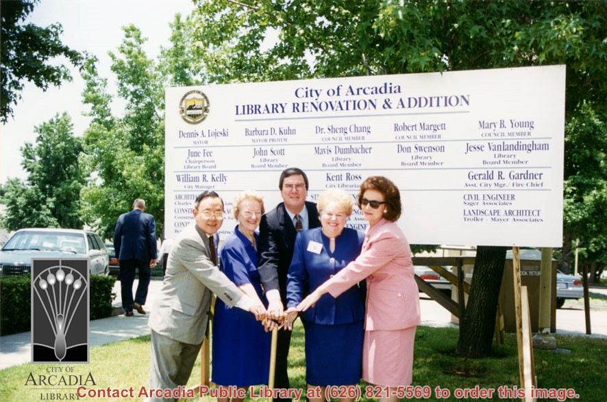
Groundbreaking ceremonies for the remodel/expansion project at Arcadia Public Library, 20 W. Duarte Road. This photo shows four council members and City Clerk June Alford holding a shovel and standing in front of a large sign announcing the remodel. L-R: Sheng Chang, Mary Young, Mayor Dennis Lojeski, Barbara Kuhn and June Alford.
https://arcadiahistory.andornot.com/en/permalink/photographs1490
- Date
- June, 1995
1 image
- Date
- June, 1995
- Subjects
- Arcadia Public Library, 1990-1999
- Chang, Sheng
- Young, Mary
- Lojeski, Dennis
- Kuhn, Barbara
- Alford, June
- Physical Description
- 4x6 and 5x7 color
- ID
- 1474
- Collection
- Photographs
Images
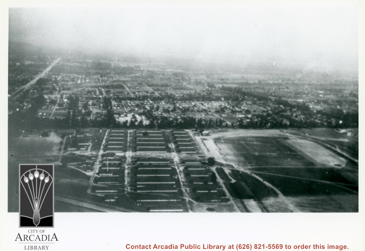
Looking east over barracks and main building at Ross Field. Tree-lined street cutting across photo at far side of field is Santa Anita Avenue. The oval of the race track built by E.J."Lucky" Baldwin and which opened in 1907 can clearly be seen on right. Broad E/W street seen on far left is Huntington Drive.
https://arcadiahistory.andornot.com/en/permalink/photographs867
- Date
- c.1928
1 image
Groundbreaking ceremonies for the remodel/expansion project at Arcadia Public Library, 20 W. Duarte Road. This photo shows Mayor Dennis Lojeski to the left standing at a podium. Very little of the audience is visible. Councilmembers Barbara Kuhn, Sheng Chang, Mary Young (who is leaning forward); City Manager Bill Kelly and City Clerk June Alford are seated on the right side of the photo.
https://arcadiahistory.andornot.com/en/permalink/photographs1501
- Date
- June, 1995
1 image
- Date
- June, 1995
- Subjects
- Arcadia Public Library, 1990-1999
- Lojeski, Dennis
- Kuhn, Barbara
- Young, Mary
- Chang, Sheng
- Kelly, Bill
- Alford, June
- Physical Description
- 4x6 color
- ID
- 1485
- Collection
- Photographs
Images


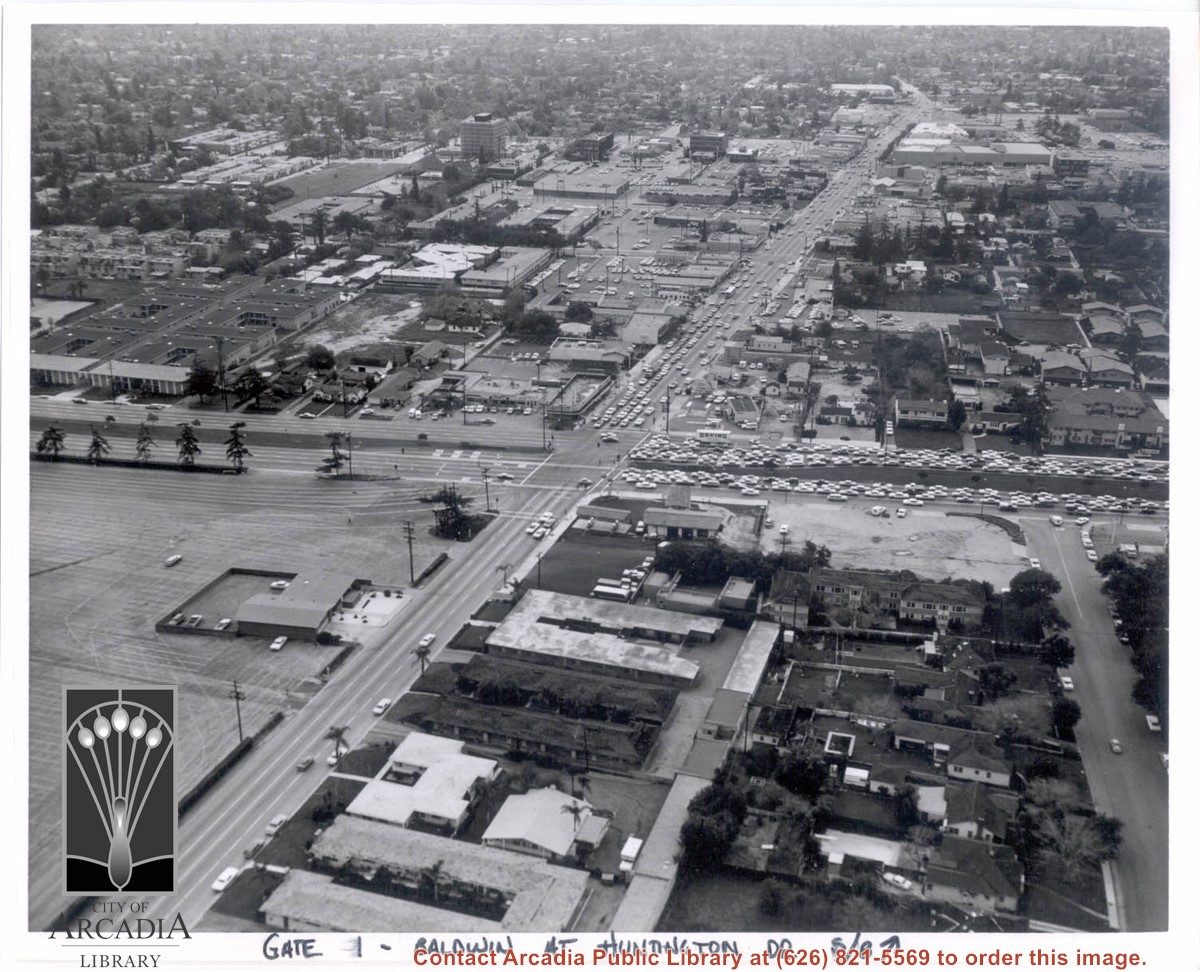
Aerial view south on Baldwin Avenue. From position just north of Huntington Drive (during racing season) showing great number of cars coming east on Huntington Drive to races through Gate #1. One building in Santa Anita Park Race Track parking lot is Fire Station at 630 S. Baldwin Avenue. Duarte Road is distantly seen in upper portion of photo, about 1 1/4 in. from top of photo. The multi-storied Medical Building seen is at 612 W. Duarte Road.
https://arcadiahistory.andornot.com/en/permalink/photographs636
- Date
- c.1970
1 image
- Date
- c.1970
- Subjects
- Aerial Photo Collection
- Aerial views
- Arcadia Fire Department
- Baldwin Avenue
- Duarte Road
- Huntington Drive
- Santa Anita Park-1945-1980
- Physical Description
- 8x10 b&w
- ID
- 632
- Collection
- Photographs
Images
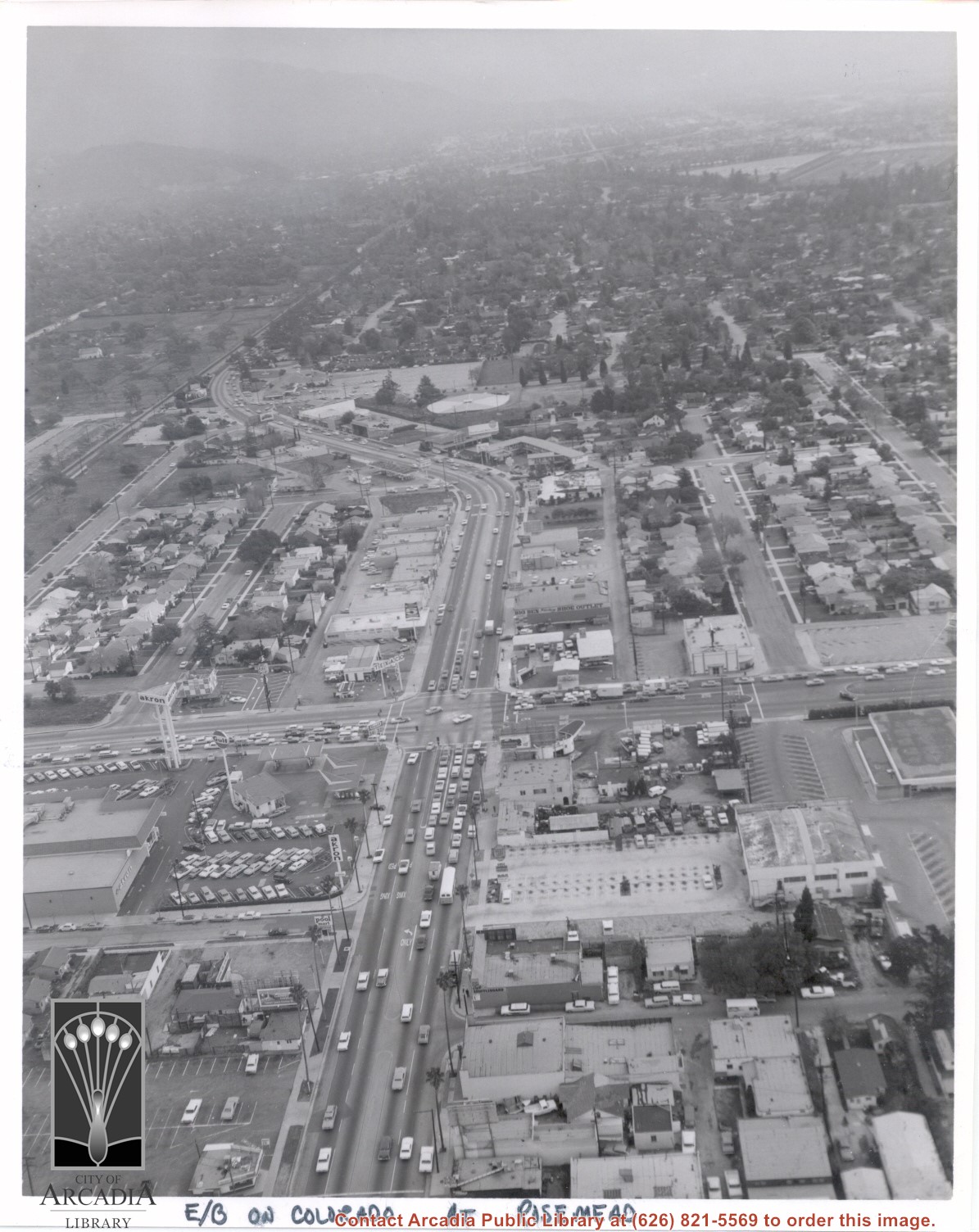
Aerial view looking east into Arcadia from near intersection of Rosemead Boulevard and Colorado Boulevard. Eaton's Santa Anita Hotel and Restaurant is still seen at far end of curve on south side of Colorado Boulevard and Michillinda Avenue (this is present site of Coco's Restaurant and Oak Tree Banquet Room, formerly Reuben's Restaurant, address 1150 W. Colorado Boulevard). The Santa Fe Railroad Tracks are seen just north of Colorado Boulevard. Large clear area in upper right portion of photo is Santa Anita Park Race Track.
https://arcadiahistory.andornot.com/en/permalink/photographs638
- Date
- c.1970
1 image
- Date
- c.1970
- Subjects
- Aerial Photo Collection
- Aerial views
- Colorado Boulevard
- Colorado Street
- Eaton's Santa Anita Hotel and Restaurant (1939-1969)
- Michillinda Avenue
- Railroads
- Santa Anita Park-1945-1980
- Physical Description
- 8x10 b&w
- ID
- 634
- Collection
- Photographs
Images
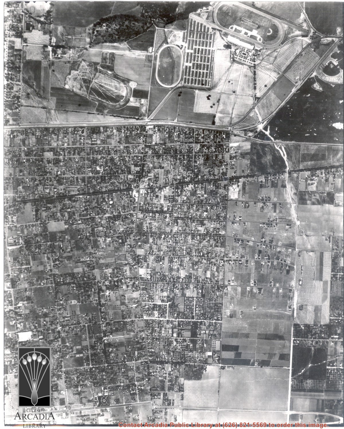
Dark, tree-lined street completely bisecting photo from west to east just above, is Duarte Road. Santa Anita Park Race Track is at upper right edge of photo. Smaller oval nearby is a training track. The incomplete oval in upper left is the race track that Anita Baldwin and Joe Smoot attempted to build in 1933 but abandoned the project. Huntington Drive and Colorado Place form a "y" just east of Santa Anita Park Race Track. Note grove of olive trees on land where City Hall is located today (240 W. Huntington Drive, Arcadia). Baseball diamond in upper right corner of photo, just below the convergence of the "y" is at Arcadia County Park. Corrected description as of 11/04/2008.
https://arcadiahistory.andornot.com/en/permalink/photographs621
- Date
- June 5, 1938
1 image
- Date
- June 5, 1938
- Subjects
- Aerial Photo Collection
- Aerial views
- Colorado Place
- Duarte Road
- Los Angeles Jockey Club
- Santa Anita Park-1934-1942
- Physical Description
- 8x10 b&w
- ID
- 617
- Collection
- Photographs
Images