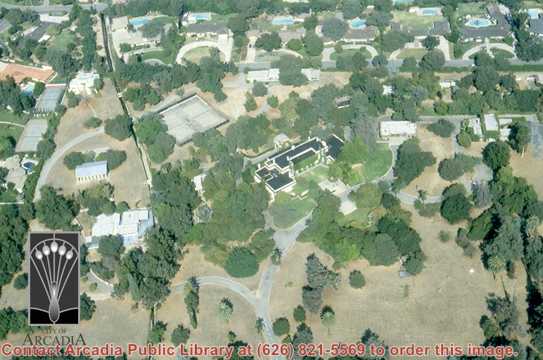
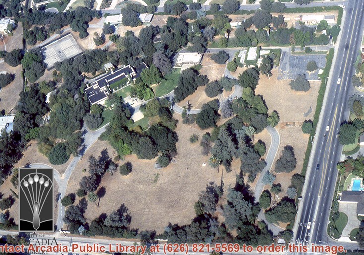
Aerial view, of Anita M. Baldwin's former estate known as Anoakia, looking north. Address was at 701 West Foothill Boulevard in Arcadia, when it was the Anoakia School. Any use of this image must be credited "Photograph by David Stevens. Copyright David Stevens."
https://arcadiahistory.andornot.com/en/permalink/photographs2411
- Date
- 1990?
1 image
- Date
- 1990?
- Subjects
- Aerial Photo Collection
- Aerial views
- Anoakia
- Anoakia School
- Baldwin, Anita M.
- David Stevens Collection
- Physical Description
- color image, digital, see i:images
- ID
- 2271
- Collection
- Photographs
Images
Aerial view, of Anita M. Baldwin's former estate known as Anoakia, looking south. Address was at 701 West Foothill Boulevard in Arcadia, when it was the Anoakia School. Any use of this image must be credited "Photograph by David Stevens. Copyright David Stevens."
https://arcadiahistory.andornot.com/en/permalink/photographs2412
- Date
- 1990?
1 image
- Date
- 1990?
- Subjects
- Aerial Photo Collection
- Aerial views
- Anoakia
- Anoakia School
- Baldwin, Anita M.
- David Stevens Collection
- Physical Description
- color image, digital, see i:images
- ID
- 2272
- Collection
- Photographs
Images
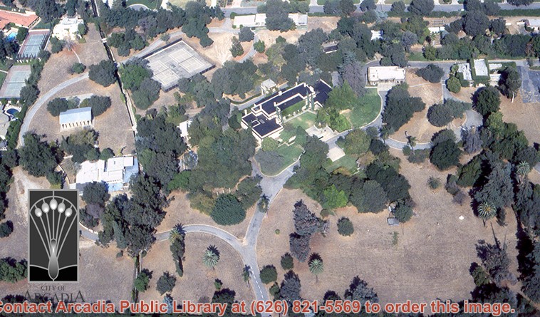
Aerial view, of Anita M. Baldwin's former estate known as Anoakia, looking north. Address was at 701 West Foothill Boulevard in Arcadia, when it was the Anoakia School. The street that runs north/south is North Baldwin Avenue. The street that runs east/west is Foothill Boulevard. Any use of this image must be credited "Photograph by David Stevens. Copyright David Stevens."
https://arcadiahistory.andornot.com/en/permalink/photographs2413
- Date
- 1990?
1 image
- Date
- 1990?
- Subjects
- Aerial Photo Collection
- Aerial views
- Anoakia
- Anoakia School
- Baldwin, Anita M.
- David Stevens Collection
- Physical Description
- color image, digital, see i:images
- ID
- 2271A
- Collection
- Photographs
Images
Aerial view, of Anita M. Baldwin's former estate known as Anoakia, looking north. Address was at 701 West Foothill Boulevard in Arcadia, when it was the Anoakia School. Any use of this image must be credited "Photograph by David Stevens. Copyright David Stevens."
https://arcadiahistory.andornot.com/en/permalink/photographs2414
- Date
- 1990?
1 image
- Date
- 1990?
- Subjects
- Aerial Photo Collection
- Aerial views
- Anoakia
- Anoakia School
- Baldwin, Anita M.
- David Stevens Collection
- Physical Description
- color image, digital, see i:images
- ID
- 2272A
- Collection
- Photographs
Images
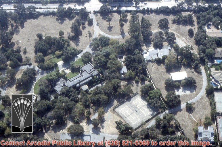
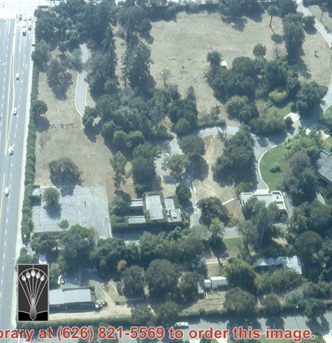
Aerial view, of Anita M. Baldwin's former estate known as Anoakia, looking west. Address was at 701 West Foothill Boulevard in Arcadia, when it was the Anoakia School. Street on the left is Foothill Boulevard? Gatehouse in the lower left corner? Any use of this image must be credited "Photograph by David Stevens. Copyright David Stevens."
https://arcadiahistory.andornot.com/en/permalink/photographs2415
- Date
- 1990?
1 image
- Date
- 1990?
- Subjects
- Aerial Photo Collection
- Aerial views
- Anoakia
- Anoakia School
- Baldwin, Anita M.
- David Stevens Collection
- Physical Description
- color image, digital, see i:images
- ID
- 2273
- Collection
- Photographs
Images
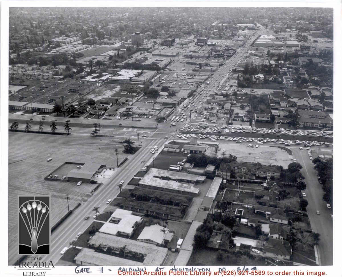
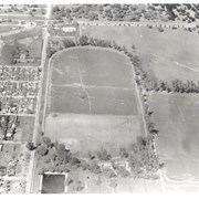
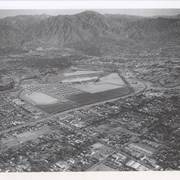
Aerial view south on Baldwin Avenue. From position just north of Huntington Drive (during racing season) showing great number of cars coming east on Huntington Drive to races through Gate #1. One building in Santa Anita Park Race Track parking lot is Fire Station at 630 S. Baldwin Avenue. Duarte Road is distantly seen in upper portion of photo, about 1 1/4 in. from top of photo. The multi-storied Medical Building seen is at 612 W. Duarte Road.
https://arcadiahistory.andornot.com/en/permalink/photographs636
- Date
- c.1970
1 image
- Date
- c.1970
- Subjects
- Aerial Photo Collection
- Aerial views
- Arcadia Fire Department
- Baldwin Avenue
- Duarte Road
- Huntington Drive
- Santa Anita Park-1945-1980
- Physical Description
- 8x10 b&w
- ID
- 632
- Collection
- Photographs
Images
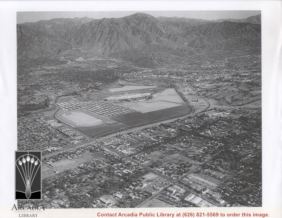
Aerial view showing Eaton's Santa Anita in foreground, looking south from Colorado Boulevard and Michillinda Avenue. Lucky Baldwin's one mile training track built in 1876 is visible with stud barn buildings on south end of track.
https://arcadiahistory.andornot.com/en/permalink/photographs1541
- Date
- March 7, 1940
1 image
- Date
- March 7, 1940
- Subjects
- Aerial Photo Collection
- Aerial views
- Baldwin, Elias J. "Lucky" - Horses and horse racing
- Colorado Boulevard
- Michillinda Avenue
- Rancho Santa Anita
- Restaurants, bars, etc - Eaton's Santa Anita Hotel and Restaurant
- Physical Description
- 8x10 b&w
- ID
- 1525
- Collection
- Photographs
Images
Aerial view of Rancho Santa Anita taken above Dairy, looking north, with 5,000,000 gallon reservoir in lower left, and Baldwin's one mile training track built in 1876 with stud barn buildings on south end of track. Eaton's Santa Anita at Colorado Boulevard and Michillinda Avenue just visible at top of photo.
https://arcadiahistory.andornot.com/en/permalink/photographs1542
- Date
- March 7, 1940
1 image
- Date
- March 7, 1940
- Subjects
- Aerial Photo Collection
- Aerial views
- Baldwin, Elias J. "Lucky" - Horses and horse racing
- Colorado Boulevard
- Michillinda Avenue
- Rancho Santa Anita
- Restaurants, bars, etc - Eaton's Santa Anita Hotel and Restaurant
- Physical Description
- 8x10 b&w
- ID
- 1526
- Collection
- Photographs
Images

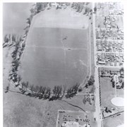
Aerial view looking towards San Gabriel Mountains showing intersection of Baldwin Avenue and Huntington Drive, the Santa Anita Park and training track where Santa Anita Fashion Park (currently known as Westfield Santa Anita Shopping Mall) was built.
https://arcadiahistory.andornot.com/en/permalink/photographs1754
- Date
- Unknown
1 image
- Date
- Unknown
- Subjects
- Aerial Photo Collection
- Aerial views
- Baldwin Avenue
- Huntington Drive
- Malls
- San Gabriel Mountains
- Santa Anita Fashion Park
- Santa Anita Park, 1945-1980
- Westfield Santa Anita Shopping Mall
- Physical Description
- 8x10 b&w photocopy
- ID
- 1742
- Collection
- Photographs
Images
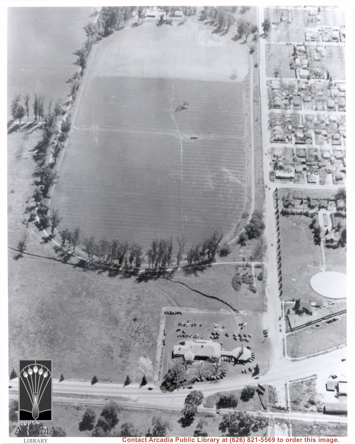
Santa Anita Park Race Track just right of center at south edge of photo. Oval to the left of Santa Anita Park Race Track was training track which was removed to make room for Santa Anita Fashion Park (currently Westfield Santa Anita Shopping Mall). Street just to left of training track is Baldwin Avenue. Huntington Drive and Colorado Place form a "y" just east of Santa Anita Park Race Track. Along both can be noticed the conifer trees planted a few years earlier. Street completely bisecting photo just below center is Foothill Boulevard, next one is Orange Grove Avenue. Santa Anita Avenue is partially in view on right edge of photo. Oval on extreme lower left side of photo is old Baldwin training track. Baseball diamond in lower right corner is at Arcadia County Park. Scale: 1"=660'
https://arcadiahistory.andornot.com/en/permalink/photographs620
- Date
- June 5, 1938
1 image
- Date
- June 5, 1938
- Subjects
- Aerial Photo Collection
- Aerial views
- Baldwin Avenue
- Colorado Boulevard
- Colorado Place
- Colorado Street
- Foothill Boulevard
- Huntington Drive
- Orange Grove Avenue
- Santa Anita Fashion Park (later known as Westfield Santa Anita)
- Santa Anita Park-1934-1942
- Physical Description
- 8x10 b&w
- ID
- 616
- Collection
- Photographs
Images

