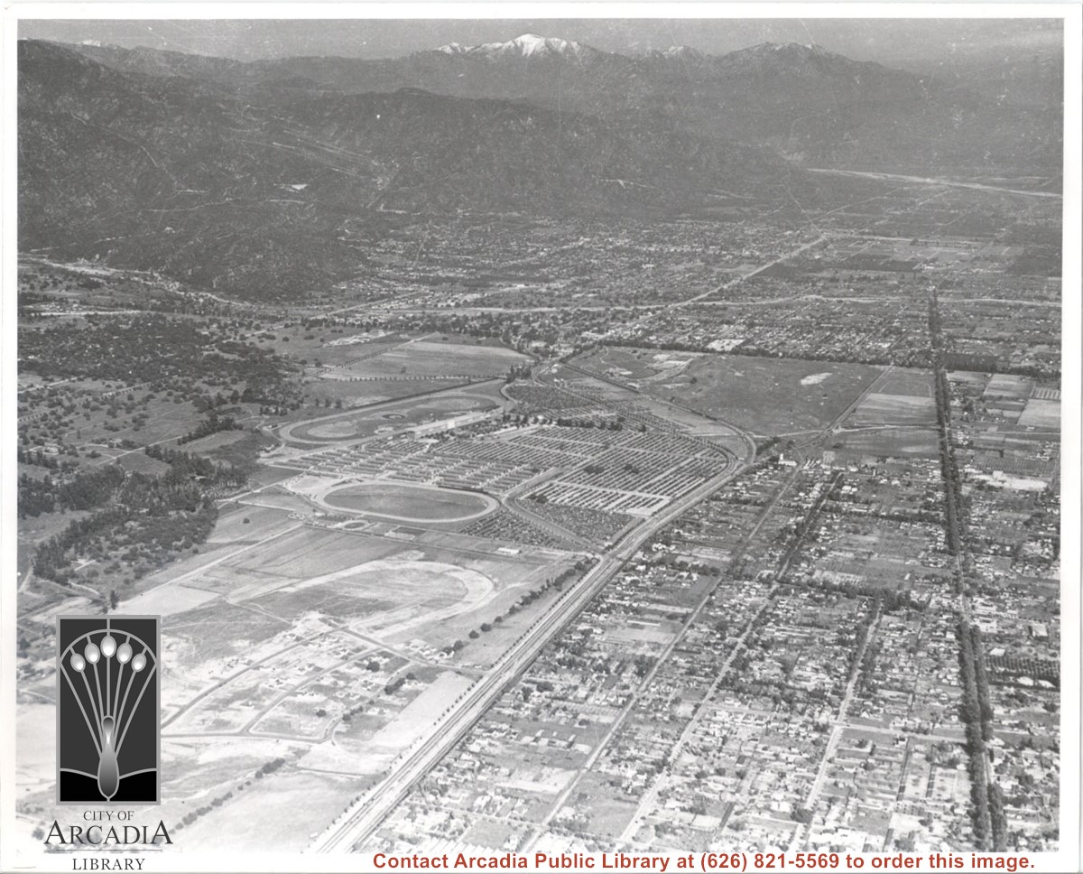
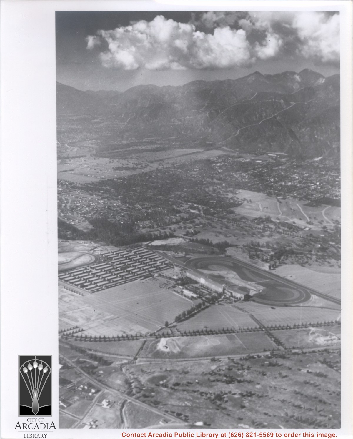
Aerial view. Looking east. Street along right edge of photo which is lined with trees is Duarte Road. Santa Anita Avenue cuts across photo from right to left and up into the San Gabriel Mountains. Huntington Drive can be seen in center of photo with young trees planted on north side of it. Santa Anita Race Track is one furthest from camera. The next small track is a training track belonging to Santa Anita. There is a VERY small round track across the street from the training track, which was part of a private horse stables. The incompleted oval was part of work done in 1933 by Joe Smoot and Anita Baldwin in their effort to develop the Jockey Club Track. This photo belongs to the Huntington Library. It is shown here for research only.
https://arcadiahistory.andornot.com/en/permalink/photographs627
- Date
- c. 1935
1 image
- Date
- c. 1935
- Subjects
- Duarte Road
- Huntington Drive
- Los Angeles Jockey Club
- San Gabriel Mountains
- Santa Anita Park-1934-1942
- Physical Description
- 8x10 b&w
- ID
- 623
- Collection
- Photographs
Images
Aerial view looking towards San Gabriel Mountains showing intersection of Baldwin Avenue and Huntington Drive, the Santa Anita Park and training track where Santa Anita Fashion Park (currently known as Westfield Santa Anita Shopping Mall) was built.
https://arcadiahistory.andornot.com/en/permalink/photographs1754
- Date
- Unknown
1 image
- Date
- Unknown
- Subjects
- Aerial Photo Collection
- Aerial views
- Baldwin Avenue
- Huntington Drive
- Malls
- San Gabriel Mountains
- Santa Anita Fashion Park
- Santa Anita Park, 1945-1980
- Westfield Santa Anita Shopping Mall
- Physical Description
- 8x10 b&w photocopy
- ID
- 1742
- Collection
- Photographs
Images
Aerial view taken from about over what became Campus Drive and Arcadia High School, and looking toward (NW) Pasadena and Sierra Madre at foot of San Gabriel Mountains. Photo shows Santa Anita Park Race Track possibly just a few years after opening.
https://arcadiahistory.andornot.com/en/permalink/photographs633
- Date
- c.1936
1 image
- Date
- c.1936
- Subjects
- Aerial Photo Collection
- Aerial views
- Arcadia High School
- Campus Drive
- San Gabriel Mountains
- Santa Anita Park-1934-1942
- Physical Description
- 8x10 b&w
- ID
- 629
- Collection
- Photographs
Images
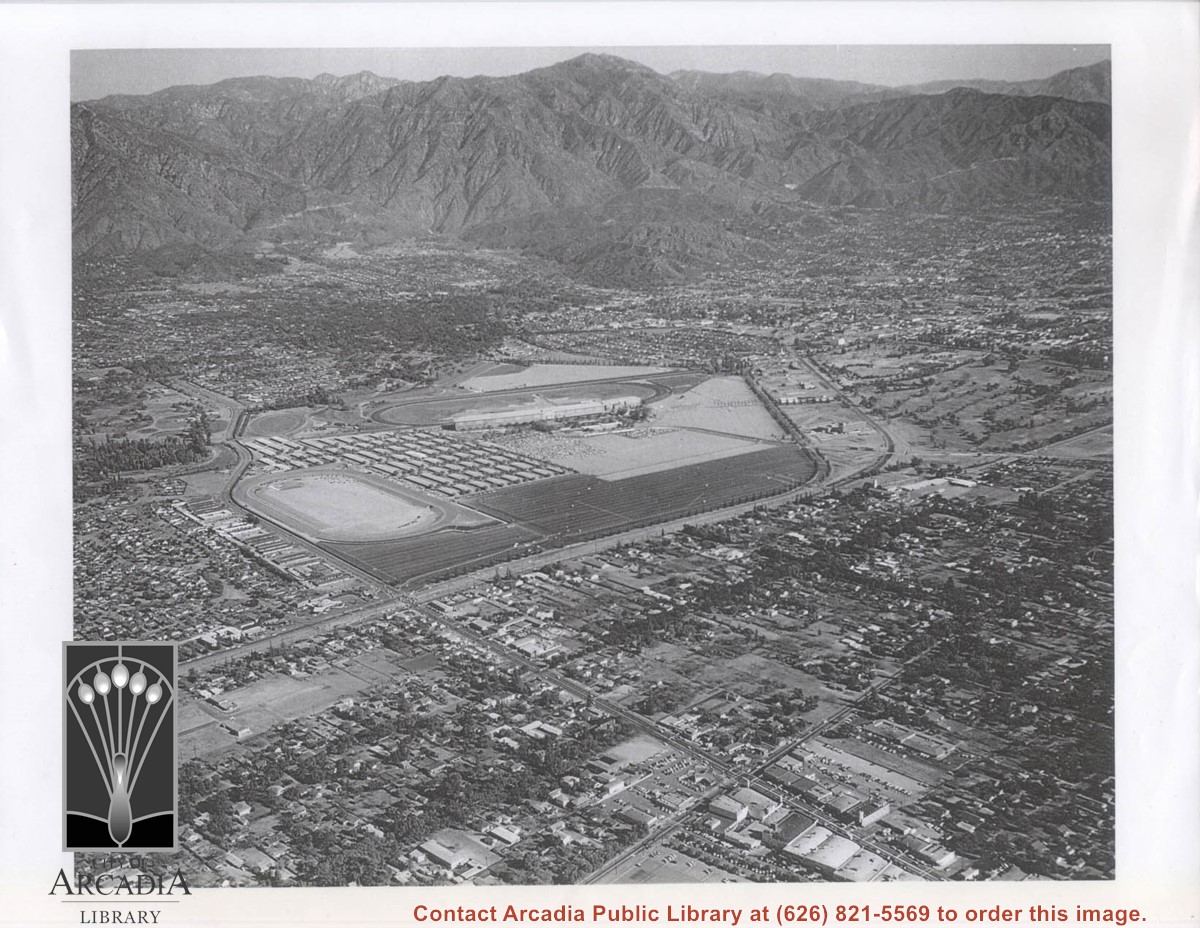
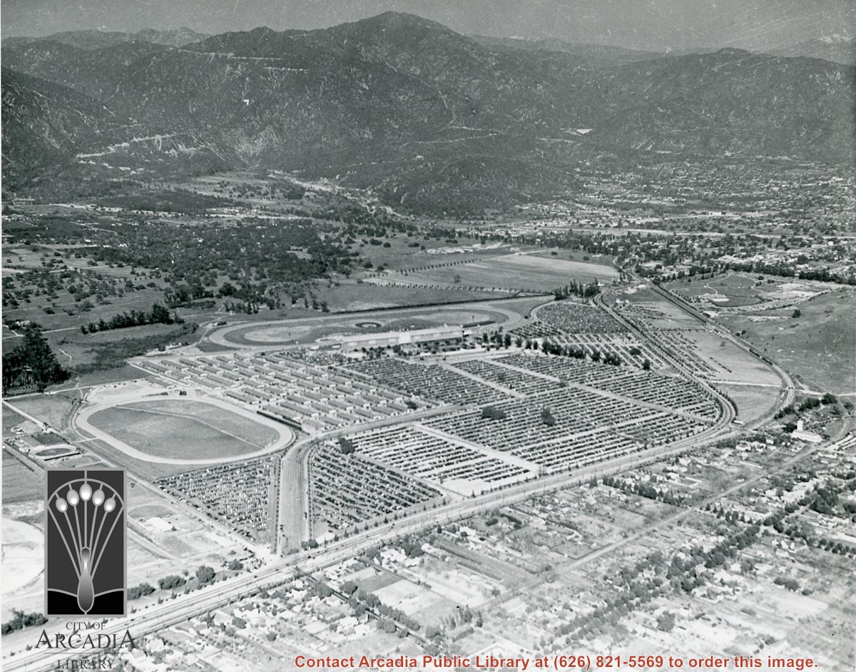
Aerial view toward NE. Main thoroughfare cutting across east to west with young trees planted on north side, is Huntington Drive. Main race track at Santa Anita is seen almost directly in center of photo, with Club House on side closest to camera. The smaller oval near left edge of photo was a training track belonging to Santa Anita which was removed for the Fashion Park. The Chantry Flats Road up to Santa Anita Canyon is clearly seen as it zig-zags around San Gabriel Mountains. This photo belongs to the Huntington Library. It is shown here for research only.
https://arcadiahistory.andornot.com/en/permalink/photographs629
- Date
- c. 1940s
1 image
- Date
- c. 1940s
- Subjects
- San Gabriel Mountains
- Santa Anita Park-1934-1942
- Chantry Flats Road
- Huntington Drive
- Fashion Park
- Physical Description
- 8x10 b&w
- ID
- 625
- Collection
- Photographs
Images
Aerial view toward north from a position south of Huntington Drive near intersection with Baldwin Avenue. It shows Santa Anita Fashion Park (currently known as Westfield Santa Anita Shopping Mall) developed by and on property owned by Santa Anita Consolidated. The Santa Anita Park Race Track and club house can be seen in center of photo. The straight white line about one inch above the club house roof is 210 Foothill Freeway. Chantry Flats road can be seen going up into San Gabriel Mountains in distance.
https://arcadiahistory.andornot.com/en/permalink/photographs646
- Date
- c. 1975
1 image
- Date
- c. 1975
- Subjects
- Aerial Photo Collection
- Aerial views
- 210 Foothill Freeway
- Chantry Flats Road
- Malls
- San Gabriel Mountains
- Santa Anita Park-1945-1980
- Santa Anita Fashion Park
- Westfield Santa Anita Shopping Mall
- Physical Description
- 8x10 b&w
- ID
- 642
- Collection
- Photographs
Images


The Apache marching band will participate in the annual Festival of Bands. Dallas Massey, Apache Tribal Chairman for the White Mountain Apaches, will be the Grand Marshal of the parade.
https://arcadiahistory.andornot.com/en/permalink/newspaper27755
- Newspaper
- Arcadia Weekly
- Date
- November 16, 2000
- Pages
- p. 1
- Subjects
- Apache Nation
- Arcadia High School - Apache Marching Band
- Festival of Bands
- Massey, Dallas
- White Mountain Apaches
- Item ID
- 27952AN
- Collection
- Newspaper Index
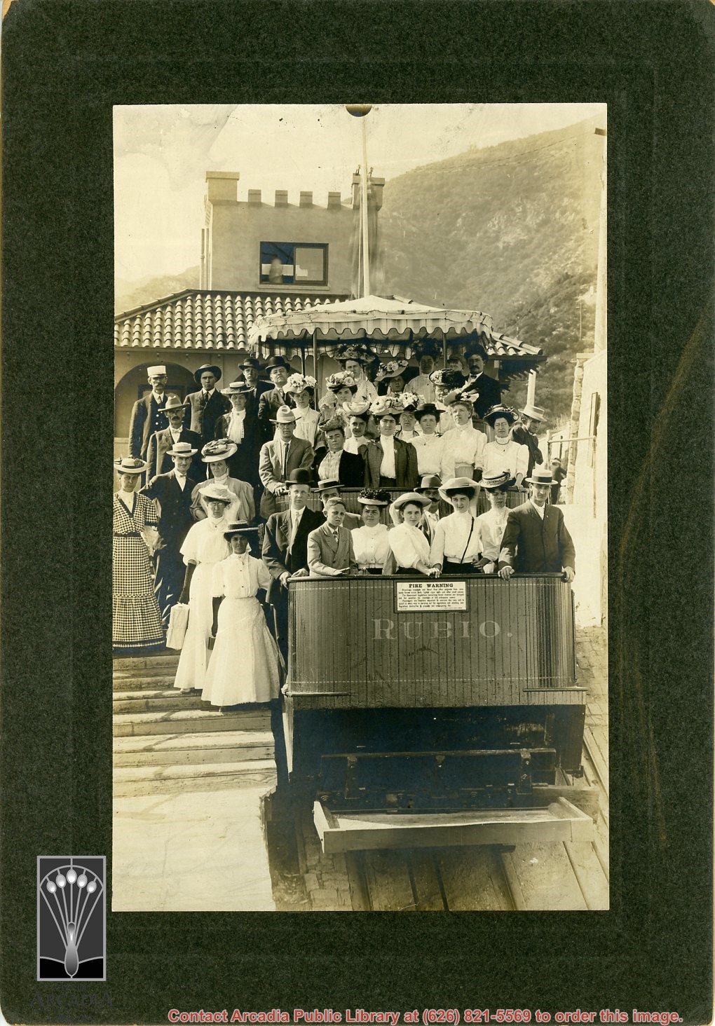
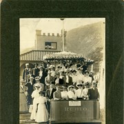
Approximately 36 men and women, many about to make the descent in the Mt. Rubio incline railroad car. (For info on this line, see Altadena Golden Years, p. 56.)
https://arcadiahistory.andornot.com/en/permalink/photographs617
- Date
- c. 1893
1 image
- Date
- c. 1893
- Subjects
- Recreation
- San Gabriel Mountains
- Physical Description
- 7x10 b&w
- ID
- 613
- Collection
- Photographs
Images
Arcadia has new hiking shuttle. U.S. Forest Service starts bus service to Chantry Flat trails from Arcadia Gold Line station. The shuttle goes to Chantry Flat Road, an area that connects to trails that lead to Sturtevant Falls, Hermit Falls, and historic Mount Wilson. The shuttle will run the next three weekends. Plans to make it permanent have not been formulated. See also Pasadena Star News, September 21, 2016, p. A7.
https://arcadiahistory.andornot.com/en/permalink/newspaper34675
- Newspaper
- Pasadena Star News
- Date
- September 20, 2016
- Pages
- p. A1, A6
- Subjects
- Angeles National Forest
- Bus
- Chantry Flat
- Hiking
- San Gabriel Mountains
- Shuttle Service
- United States Forest Service
- Item ID
- 34867AN
- Collection
- Newspaper Index
Arcadia High School students come to the aid of Apache Native Americans who suffered losses from a brush fire in Cabecue, Arizona.
https://arcadiahistory.andornot.com/en/permalink/newspaper30479
- Newspaper
- Arcadia Weekly
- Date
- July 4, 2002
- Pages
- p. 1
- Subjects
- Apache Nation
- Arcadia High School - Students
- Native American Indian Tribes
- White Mountain Tribe
- Item ID
- 30666AN
- Collection
- Newspaper Index
Arcadia High students are collecting toiletries and other items to aid members of the White Mountain Apache Tribe who were displaced by a massive wildfire. They have formed the "Apache to Apache" drive. Because the high school mascot is the Apache, students have developed a close relationship with the Native Americans who live on a reservation in Arizona.
https://arcadiahistory.andornot.com/en/permalink/newspaper23959
- Newspaper
- Pasadena Star News
- Date
- June 28, 2002
- Pages
- p. A1
- Item ID
- 24159AN
- Collection
- Newspaper Index
Arcadia police shot a mountain lion, or cougar, at 8 PM in the backyard of a home in the 2200 block of Canyon Road. The mountain lion had just mauled a dog to death and was charging at police when police shot the cat with an assault weapon.
https://arcadiahistory.andornot.com/en/permalink/newspaper31281
- Newspaper
- Pasadena Star News
- Date
- November 7, 2008
- Pages
- p. A1
- Subjects
- Big cats
- Cougars
- Mountain Lions
- Wild animals
- Item ID
- 31476AN
- Collection
- Newspaper Index
Arcadia Unified School District to reconsider Apaches as mascot amid online petition drive, officials say it is on agenda. It is a revival of a 20-year-old controversy to remove Apaches name and imagery amid a nationwide movement to erase offensive emblems. Shayan Farooq, a 2013 graduate of Arcadia High School, felt the issue needed to be addressed. Farooq started a petition at Change.org. AUSD spokesperson Ryan Foran said the issue will be addressed in its list of priorities after reopening schools during the coronavirus pandemic and recent sexual assault allegations involving current and former students who were video recorded, without consent, having sex. Controversy surrounding the Apaches mascot dates back two decades when Native American activists protested the Apache Joe mascot at Arcadia school board meetings in 1999. Then Principal Martin Plourde sought the White Mountain Apache Tribe's blessing to use the imagery and tribal leaders approved, but many students at Alchesay High School (Arcadia High School's sister school on Apache reservation) found the mascot offensive and urged Plourde to change it. 2018 Arcadia High School graduate Yumei Lin is leading a Facebook group to change the emblem.
https://arcadiahistory.andornot.com/en/permalink/newspaper35782
- Newspaper
- Pasadena Star News
- Date
- July 14, 2020
- Pages
- p. A1, A7
- Subjects
- Arcadia High School mascot
- Farooq, Shayan
- Lin, Yumei
- Plourde, Martin
- White Mountain Apache Tribe
- Collection
- Newspaper Index
Assembly Bill 2115 goes to the state legislature. It calls for a ban on using the name Apaches by Arcadia Unified School District sports teams.
https://arcadiahistory.andornot.com/en/permalink/newspaper30282
- Newspaper
- Arcadia Weekly
- Date
- May 2, 2002
- Pages
- p. 1
- Subjects
- Arcadia High School Apaches logo
- Arcadia High School mascot
- Assembly bills
- Native American Indian Tribes
- White Mountain Apache Nation
- Item ID
- 30469AN
- Collection
- Newspaper Index
Bill seeks addition to forest landscape. Rep. Judy Chu, D-Pasadena, hopes to expand San Gabriel Mountains National Monument by 100,000-plus acres with the San Gabriel Mountains Protection Act, written by Representative Judy Chu. The San Gabriel Mountains are north of Arcadia.
https://arcadiahistory.andornot.com/en/permalink/newspaper36488
- Newspaper
- Pasadena Star News
- Date
- May 30, 2023
- Pages
- p. A1, A7
- Collection
- Newspaper Index
Bobcat Fire continues to wreak havoc. Nearly 24,000 acres burned above foothill communities, north of Monrovia, and still spreading out of control yesterday as firefighters contended with powerful winds. The fire has burned 23,890 acres of pristine forest lands. It was 6% contained. Evacuation warnings are still in effect in Monrovia, Arcadia, Azusa, Sierra Madre, Duarte, Pasadena, Altadena & Bradbury.
https://arcadiahistory.andornot.com/en/permalink/newspaper35801
- Newspaper
- Pasadena Star News
- Date
- September 11, 2020
- Pages
- p. A1, A4
- Collection
- Newspaper Index
Bobcat Fire, on its 9th day in the San Gabriel Mountains, continued to grow north of the San Gabriel Valley. It had charred 38,299 acres Monday with containment at 3%. The fire has crossed to west side of Santa Anita Canyon. On Sunday, residents in Arcadia and Sierra Madre who live north of Elkins Avenue and east of Santa Anita Avenue were ordered to evacuate. About 305 homes were in the evacuation zone. Most are in Arcadia and 32 are in Sierra Madre.
https://arcadiahistory.andornot.com/en/permalink/newspaper35803
- Newspaper
- Pasadena Star News
- Date
- September 15, 2020
- Pages
- p. A1, A6
- Collection
- Newspaper Index
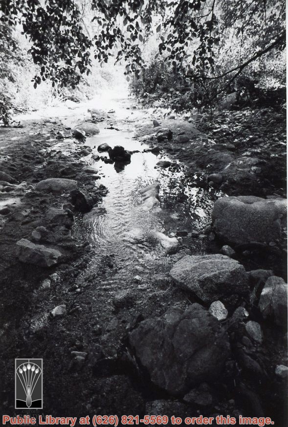
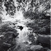
A brook at Wilderness Park. Photo by Terry Miller.
https://arcadiahistory.andornot.com/en/permalink/photographs2375
- Date
- 2001
1 image
- Date
- 2001
- Subjects
- Landscapes
- Mountains
- Nature
- Water
- Wilderness Park
- Physical Description
- 4x6 b&w
- ID
- 2256B
- Collection
- Photographs
Images
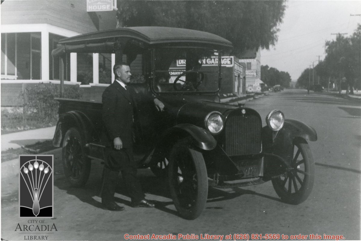
Carl Ettensperger standing by milk delivery truck owned by the Mountain View Dairy, Arcadia. This photo was on a Monrovia street. Dairy was located on Jeffries Street. (However, 1924 City Directory says Mountain View Dairy was at Valnett Ave sw corner 6th Ave.)
https://arcadiahistory.andornot.com/en/permalink/photographs1113
- Date
- c.1925
1 image
- Date
- c.1925
- Subjects
- Ettensperger, Carl
- Mountain View Dairy
- Physical Description
- 8x10 b&w
- ID
- 1104
- Collection
- Photographs
Images
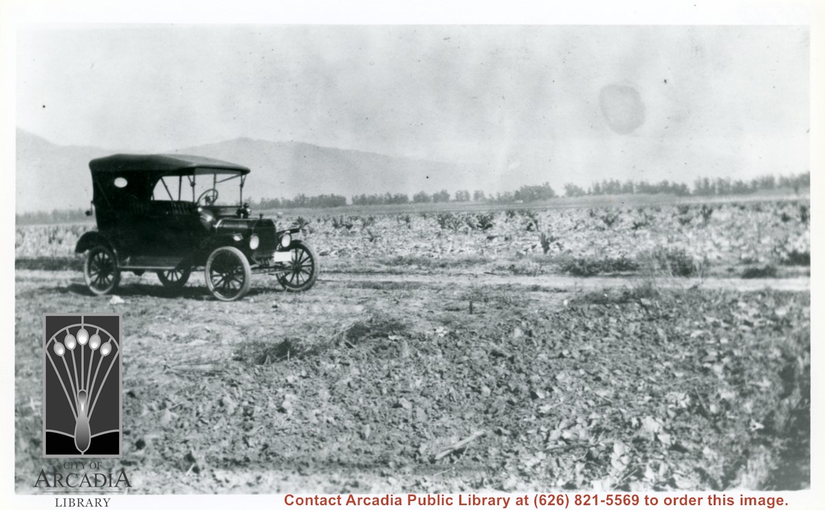
Car sitting alongside Holly Avenue at property just purchased by Aloyosius Mauch and his family near Palm Avenue and Holly Avenue. This view is toward NE.
https://arcadiahistory.andornot.com/en/permalink/photographs1007
- Date
- Feb. 1922
1 image
- Date
- Feb. 1922
- Physical Description
- 6x10 b&w (this is right portion of a panorama - photo 999 forms left portion)
- ID
- 1000
- Collection
- Photographs
Images
Councilman Gary Kovacic has suggested that Arcadia establish a sister city relationship with Whiteriver, the main community on the White Mountain Indian Reservation, upon which the White Mountain Apache Tribe live.
https://arcadiahistory.andornot.com/en/permalink/newspaper30484
- Newspaper
- Arcadia Weekly
- Date
- July 11, 2002
- Pages
- p. 8
- Subjects
- Apache Nation
- Native American Indian Tribes
- Sister cities
- White Mountain Indian Reservation
- Whiteriver (City)
- Item ID
- 30671AN
- Collection
- Newspaper Index