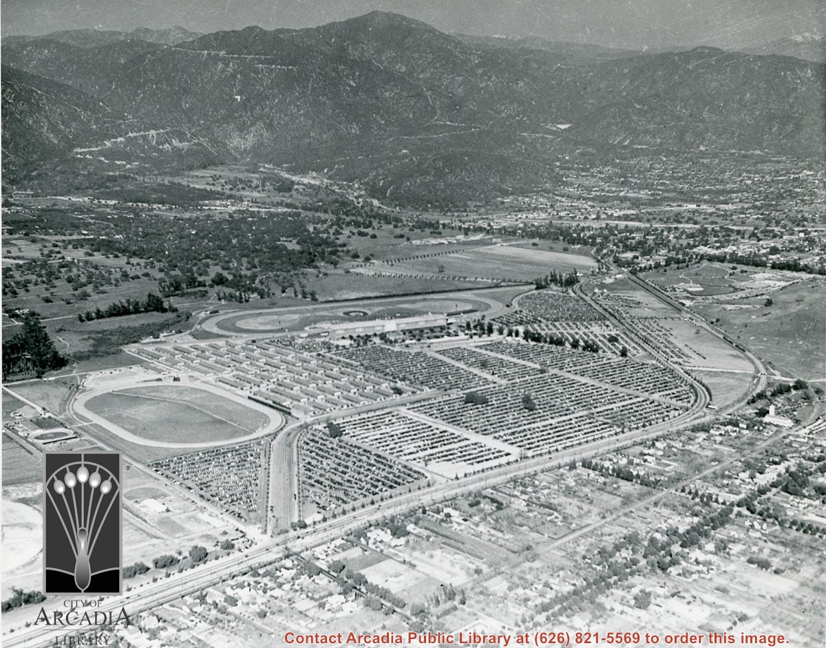
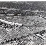
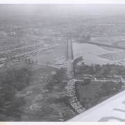
Aerial view looking east along Huntington Drive taken over the Club House at Santa Anita Park Race Track. Pony Express Museum is just to right of the "y" intersection of Huntington Drive coming into Arcadia just below the wing of the plane. Theater that was opened in 1942 is almost directly opposite Museum. Santa Anita Motor Inn, two buildings east of theater, distinguished by tall tower, opened in 1938. (It was torn down in 1975.) The residential area directly north of there is known as Santa Anita Gardens. Santa Anita Avenue is just beyond Arcadia County Park on right.
https://arcadiahistory.andornot.com/en/permalink/photographs642
- Date
- c. 1957-58
1 image
- Date
- c. 1957-58
- Subjects
- Aerial Photo Collection
- Aerial views
- Huntington Drive
- Pony Express Museum
- Santa Anita Avenue
- Santa Anita Motor Inn
- Physical Description
- 8x10 b&w
- ID
- 638
- Collection
- Photographs
Images
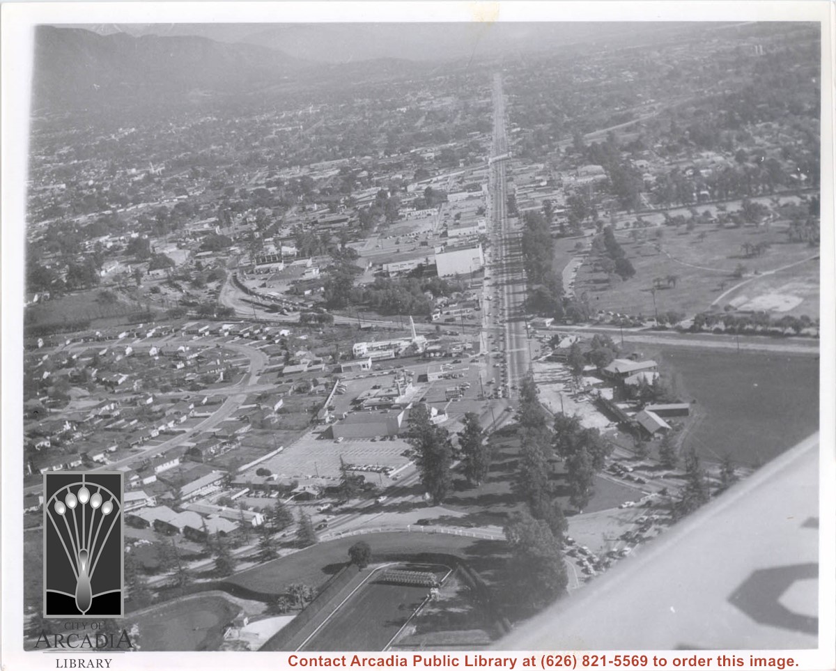
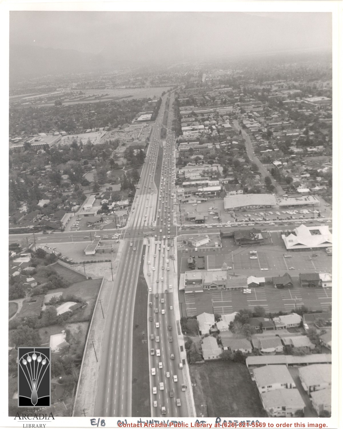
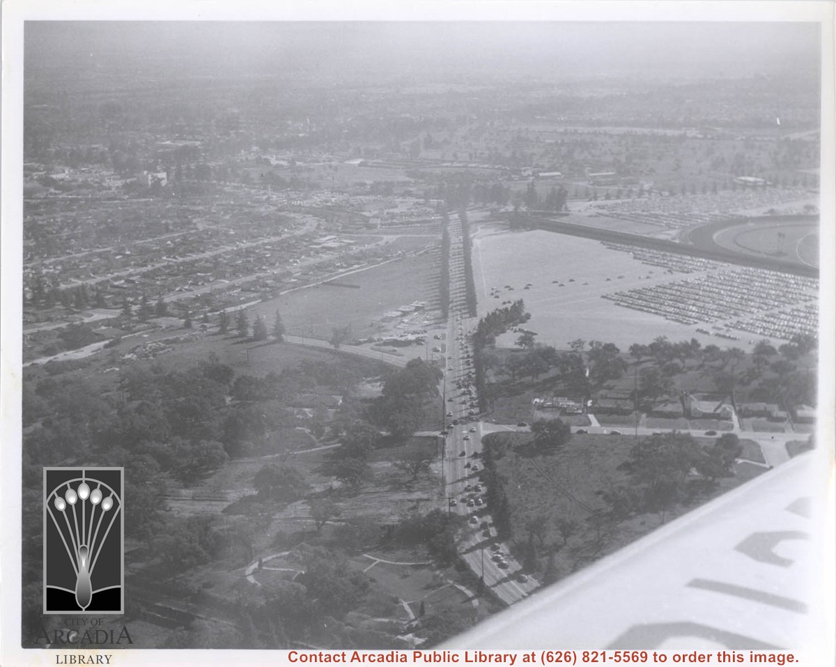
Aerial view east on Huntington Drive toward Arcadia from a position just west of Rosemead Boulevard. El Rancho Shopping Center and May Company Department Store can be seen as the business complex on the north side of Huntington Drive one block east of Rosemead Boulevard. Santa Anita Park Race Track can be seen on the left in upper portion of photo.
https://arcadiahistory.andornot.com/en/permalink/photographs637
- Date
- c.1970
1 image
- Date
- c.1970
- Subjects
- Aerial Photo Collection
- Aerial views
- El Rancho Shopping District
- Huntington Drive
- May Company Department Store
- Santa Anita Park-1945-1980
- Physical Description
- 8x10 b&w
- ID
- 633
- Collection
- Photographs
Images
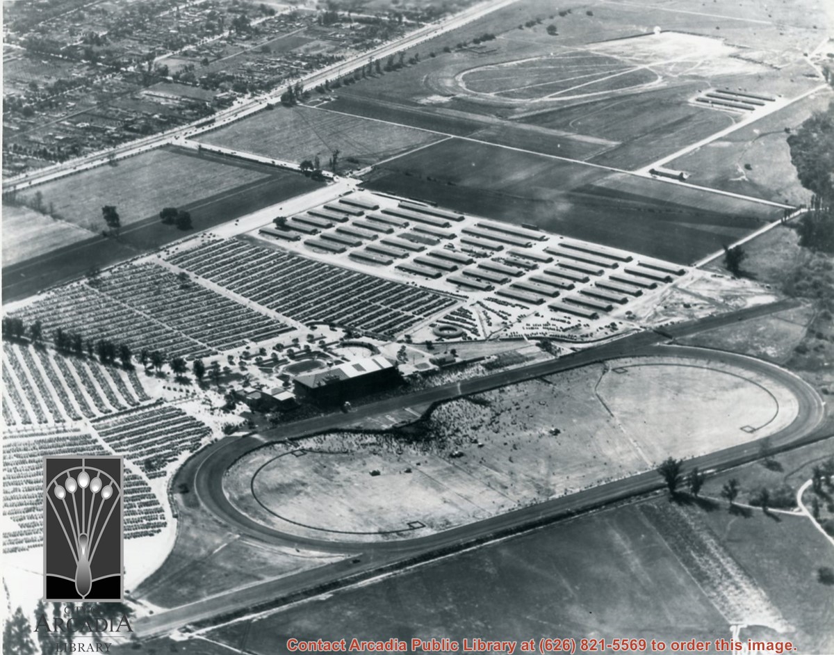
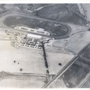
Aerial view looking west across Santa Anita Park from a position about Santa Anita Avenue just north of Huntington Drive. In the upper right portion of the photo can be seen the extensive earthwork done for the track Anita Baldwin and Joe Smoot planned to build. That vast area now is entirely built with homes and apartments and is called Santa Anita Village. Present-day Baldwin Avenue would follow the line shown by the Ranch Road bisecting the photo from right to left just east of the track abandoned by Anita Baldwin and Joe Smoot.
https://arcadiahistory.andornot.com/en/permalink/photographs985
- Date
- c.1934
1 image
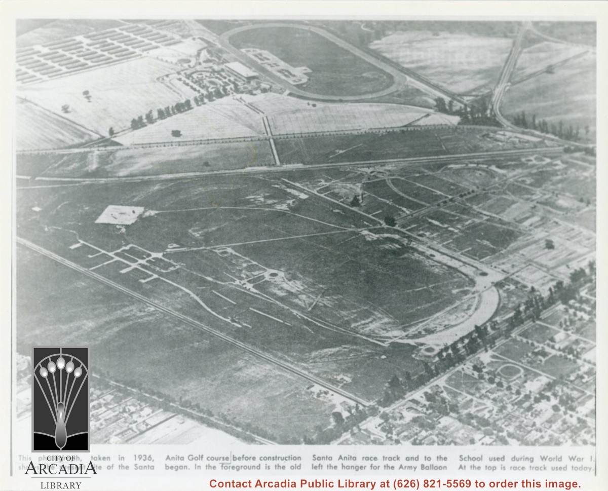
Photographically reproduced copy of an old newspaper photo taken in 1936 which is an aerial view looking north west over original race track built by Baldwin. In lower right corner can be seen Santa Anita Ave lined with Eucalyptus. On lower left, one can see present Campus Drive. Across top third of photo, one can see Huntington Drive. Note how small the trees are that line the street.
https://arcadiahistory.andornot.com/en/permalink/photographs864
- Date
- 1936
1 image
- Date
- 1936
- Subjects
- Baldwin, Elias J. "Lucky"-Horses and horse racing
- Huntington Drive
- Santa Anita Park-1907-1912
- Balloon School
- Physical Description
- 8x10 b&w
- ID
- 858
- Collection
- Photographs
Images
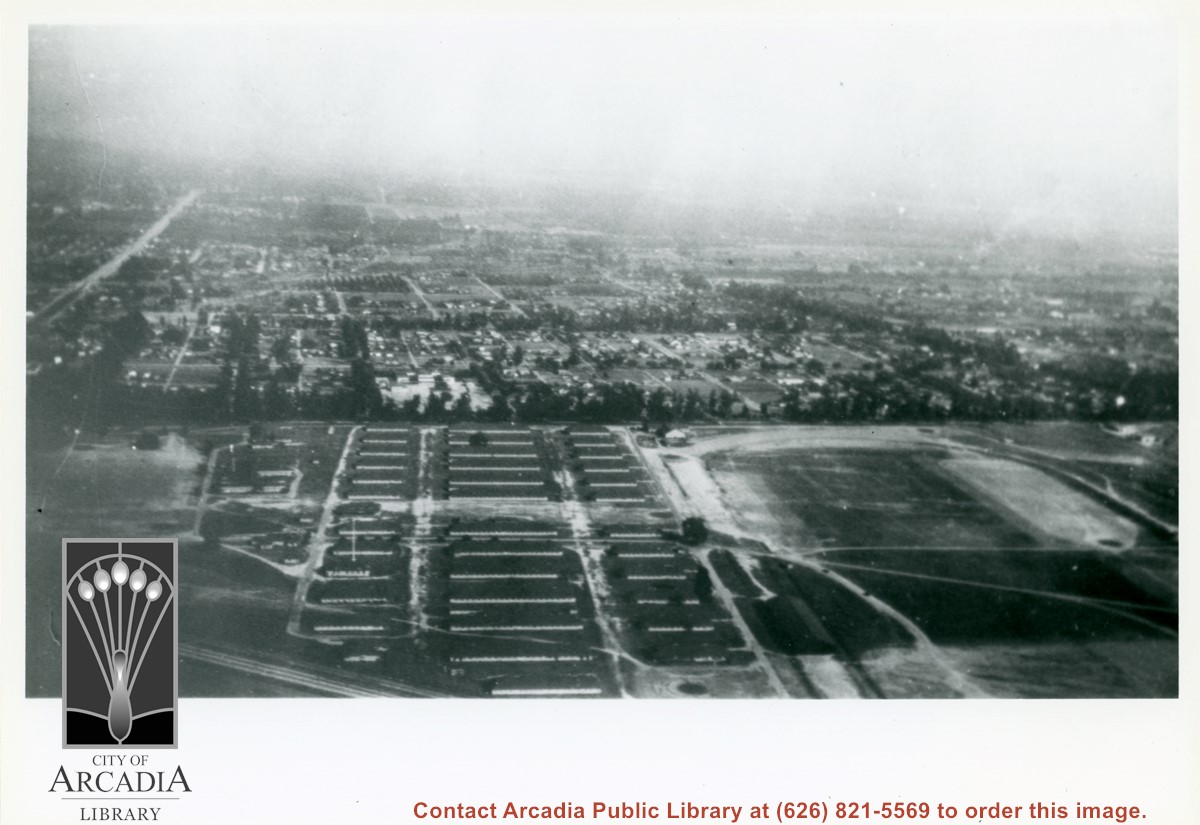
View northeast over Pacific Electric Railroad. Ross Field Balloon School occupies portion on right side of photo over to the railroad tracks. The street marking its northern boundary would be Huntington Drive. The large rectangle just north of this street was Rancho Resevoir, converted into a swimming pool. The principal street marking east boundary of Balloon School property running north to south across this photo about at middle, is Santa Anita Avenue.
https://arcadiahistory.andornot.com/en/permalink/photographs634
- Date
- November, 1929
1 image
- Date
- November, 1929
- Subjects
- Aerial Photo Collection
- Aerial views
- Balloon School
- Pacific Electric Railway
- Railroads
- Ross Field
- Physical Description
- 8x10 b&w
- ID
- 630
- Collection
- Photographs
Images

Aerial view looking east across Santa Anita Park taken from a position just west of Baldwin Avenue, which is seen at bottom of photo. Huntington Drive appears exactly in center of photo just east of race track. The 210 Foothill Freeway enters area in upper right portion of picture and exits at left side in upper left portion.
https://arcadiahistory.andornot.com/en/permalink/photographs996
- Date
- c.1979
1 image
- Date
- c.1979
- Subjects
- Aerial Photo Collection
- Aerial views
- 210 Foothill Freeway
- Huntington Drive
- Santa Anita Park-1945-1980
- Physical Description
- 8x10 b&w
- ID
- 989
- Collection
- Photographs
Images


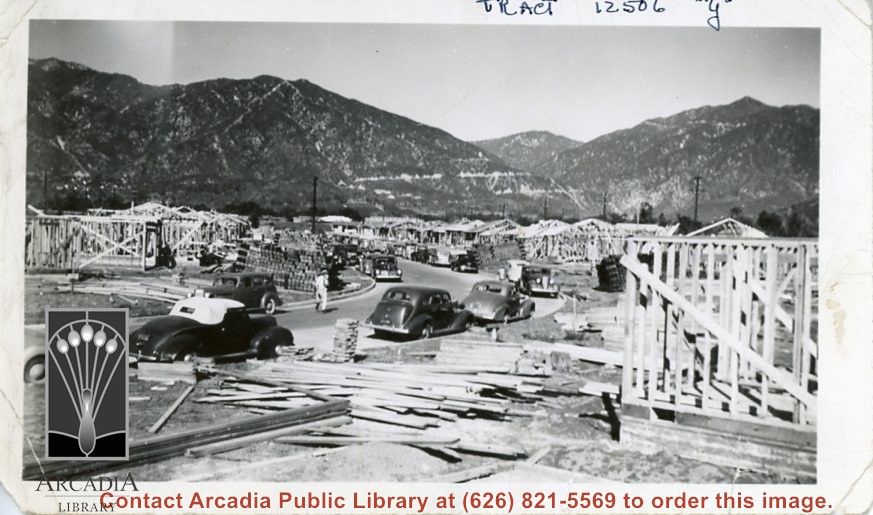
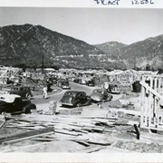
View up one street in Santa Anita Gardens area just off Huntington Drive (to the north) with houses under construction on both sides of the street. Writing on the photo indicates that it is part of Tract 12506 "Y". This tract includes San Antonio Road. Cars of the workmen are parked nearby. The Chantry Flats Road is clearly seen on the mountains in background.
https://arcadiahistory.andornot.com/en/permalink/photographs1147
- Date
- 1941
1 image
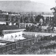
View east across concrete reservoir toward lake on Baldwin Ranch and beyond to mountains. Hugo Reid Adobe should be in trees directly under white-looking plowed field on right center part of photo. White buildings center left not identified.
https://arcadiahistory.andornot.com/en/permalink/photographs144
- Date
- c.1900's
1 image
- Date
- c.1900's
- Subjects
- Rancho Santa Anita
- Baldwin Ranch
- Physical Description
- 8x10 b&w
- ID
- 143
- Collection
- Photographs
Images

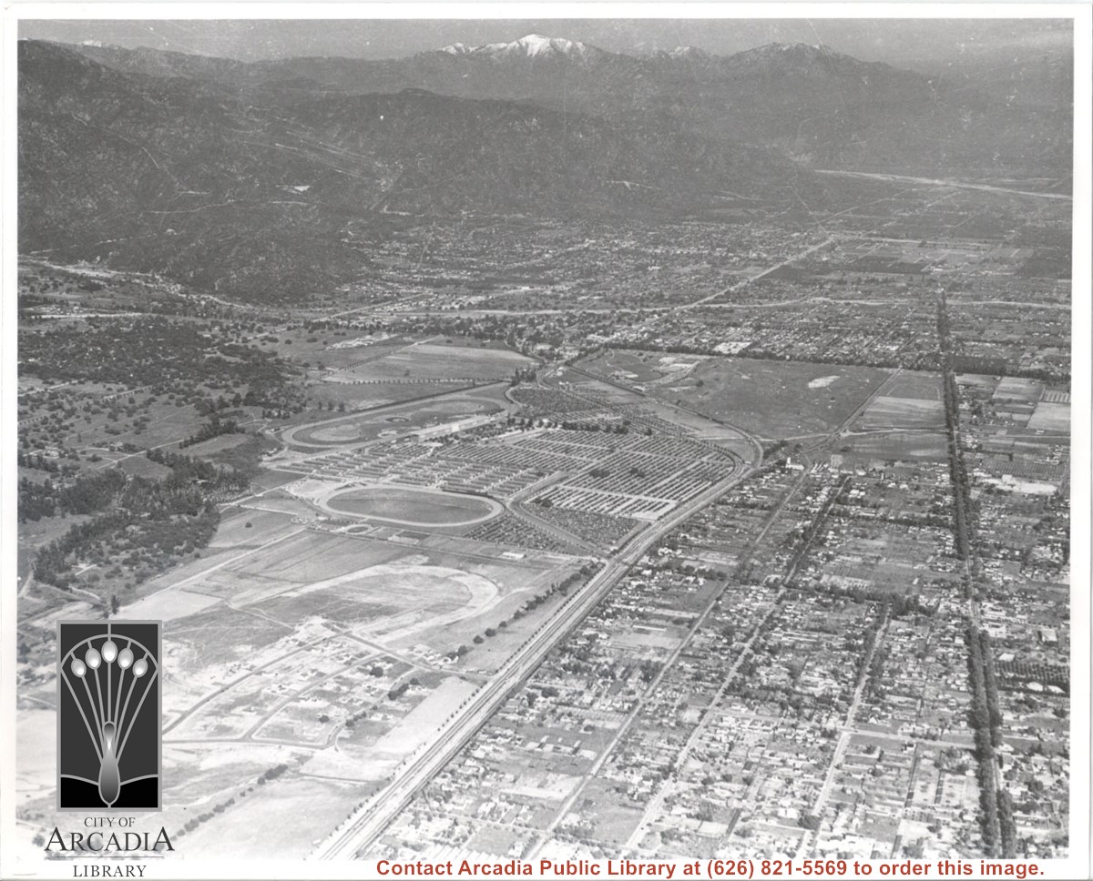
Aerial view. Looking east. Street along right edge of photo which is lined with trees is Duarte Road. Santa Anita Avenue cuts across photo from right to left and up into the San Gabriel Mountains. Huntington Drive can be seen in center of photo with young trees planted on north side of it. Santa Anita Race Track is one furthest from camera. The next small track is a training track belonging to Santa Anita. There is a VERY small round track across the street from the training track, which was part of a private horse stables. The incompleted oval was part of work done in 1933 by Joe Smoot and Anita Baldwin in their effort to develop the Jockey Club Track. This photo belongs to the Huntington Library. It is shown here for research only.
https://arcadiahistory.andornot.com/en/permalink/photographs627
- Date
- c. 1935
1 image
- Date
- c. 1935
- Subjects
- Duarte Road
- Huntington Drive
- Los Angeles Jockey Club
- San Gabriel Mountains
- Santa Anita Park-1934-1942
- Physical Description
- 8x10 b&w
- ID
- 623
- Collection
- Photographs
Images
Aerial view looking north across Santa Anita Park from a position over Arcadia County Park. Large infield crowd is evident and all parking areas are filled. Arcadia Methodist Hospital shows in lower left part of photo and Arcadia Police facility is seen in lower right. The 210 Foothill Freeway cuts across photo near the top.
https://arcadiahistory.andornot.com/en/permalink/photographs995
- Date
- c.1979
1 image
- Date
- c.1979
- Subjects
- Aerial Photo Collection
- Aerial views
- 210 Foothill Freeway
- Arcadia Methodist Hospital
- Santa Anita Park-1945-1980
- Physical Description
- 8x10 b&w
- ID
- 988
- Collection
- Photographs
Images

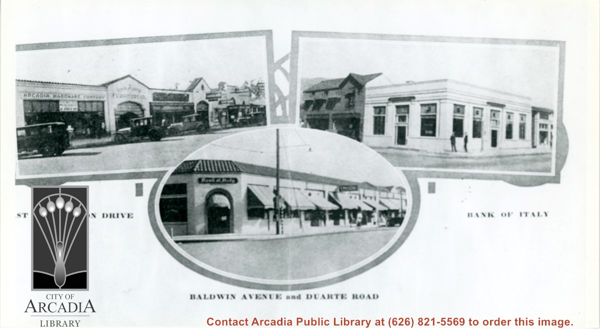
Three views of business areas in Arcadia. On left is south side of Huntington Drive. Arcadia Hardware is still located at 52 E. Huntington Drive as it is shown here. On the right is the Bank of Italy which was located on NE corner of Huntington Drive and First Ave. The building just to the north up First Ave (with awnings) is also still in use.
https://arcadiahistory.andornot.com/en/permalink/photographs896
- Date
- 1928
1 image
- Date
- 1928
- Subjects
- Business & industry
- Huntington Drive
- Baldwin Avenue
- Bank of Italy National Trust Savings
- Arcadia Hardware
- Physical Description
- 5 1/2 x 10 b&w
- ID
- 889
- Collection
- Photographs
Images
Aerial view south on Colorado Street just over large turn to the west. The residential area known as Santa Anita Gardens shows along upper left section of photo. Note that the only commerical development along the north side of Colorado Street is the Westerner Motel just near intersection with Huntington Drive. Santa Fe Railroad tracks are seen in lower left corner of photo. Santa Anita Park Race Track is on right.
https://arcadiahistory.andornot.com/en/permalink/photographs641
- Date
- c. 1956
1 image
- Date
- c. 1956
- Subjects
- Aerial Photo Collection
- Aerial views
- Colorado Boulevard
- Colorado Street
- Huntington Drive
- Railroads
- Santa Anita Park-1945-1980
- Westerner Motel
- Physical Description
- 8x10 b&w
- ID
- 637
- Collection
- Photographs
Images
Aerial view from position above Huntington Drive near Holly Avenue intersection looking north over Santa Anita Park. Colorado Place and Huntington Drive are seen coming together at right side of photo. Note how small the deodar (?) trees planted along Huntington Drive and Colorado Place are. Row of trees seen in center of photo were apparently left from Ranch days and were later removed.
https://arcadiahistory.andornot.com/en/permalink/photographs984
- Date
- December 1, 1935
1 image
- Date
- December 1, 1935
- Subjects
- Aerial Photo Collection
- Aerial views
- Colorado Place
- Huntington Drive
- Santa Anita Park-1934-1942
- Physical Description
- 8x10 b&w
- ID
- 976
- Collection
- Photographs
Images

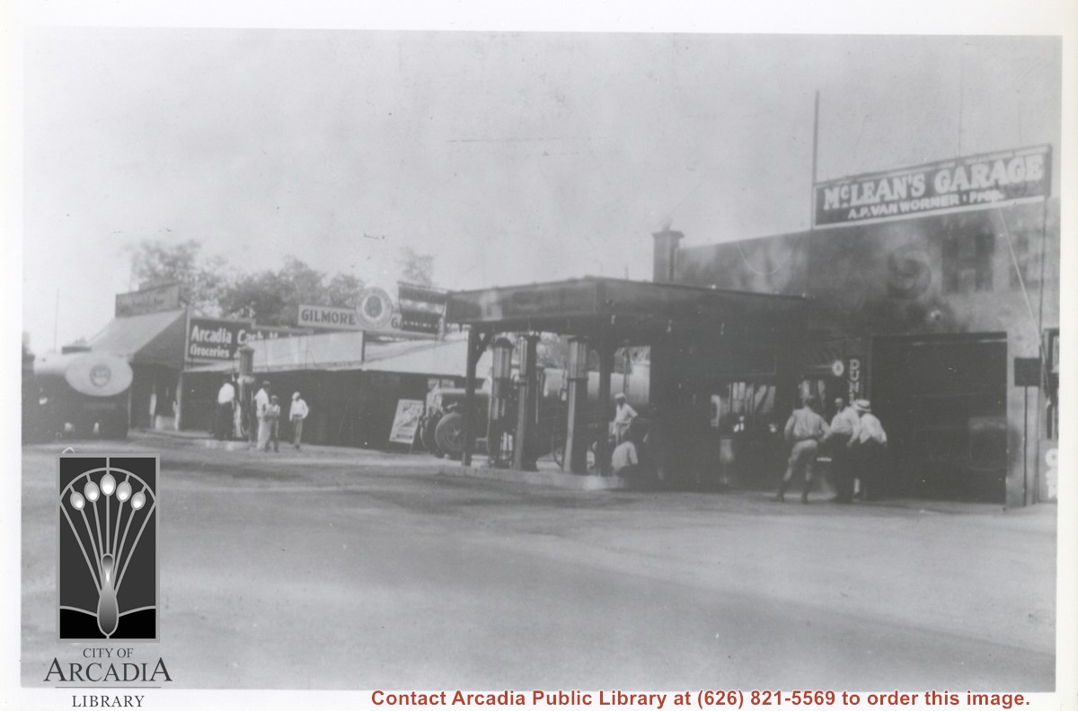
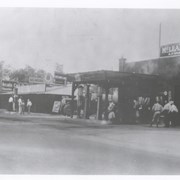
Looking north east toward intersection of Santa Anita Ave. near point where Campus Drive intersects. McLean's Garage is plainly seen on the right. A large gasoline truck is parked just to the north. Farther north can be seen Arcadia Cash Market with another tank truck parked in front. There are at least 9 people seen standing by; one, a police officer, third from right.
https://arcadiahistory.andornot.com/en/permalink/photographs855
- Date
- c.1933
1 image
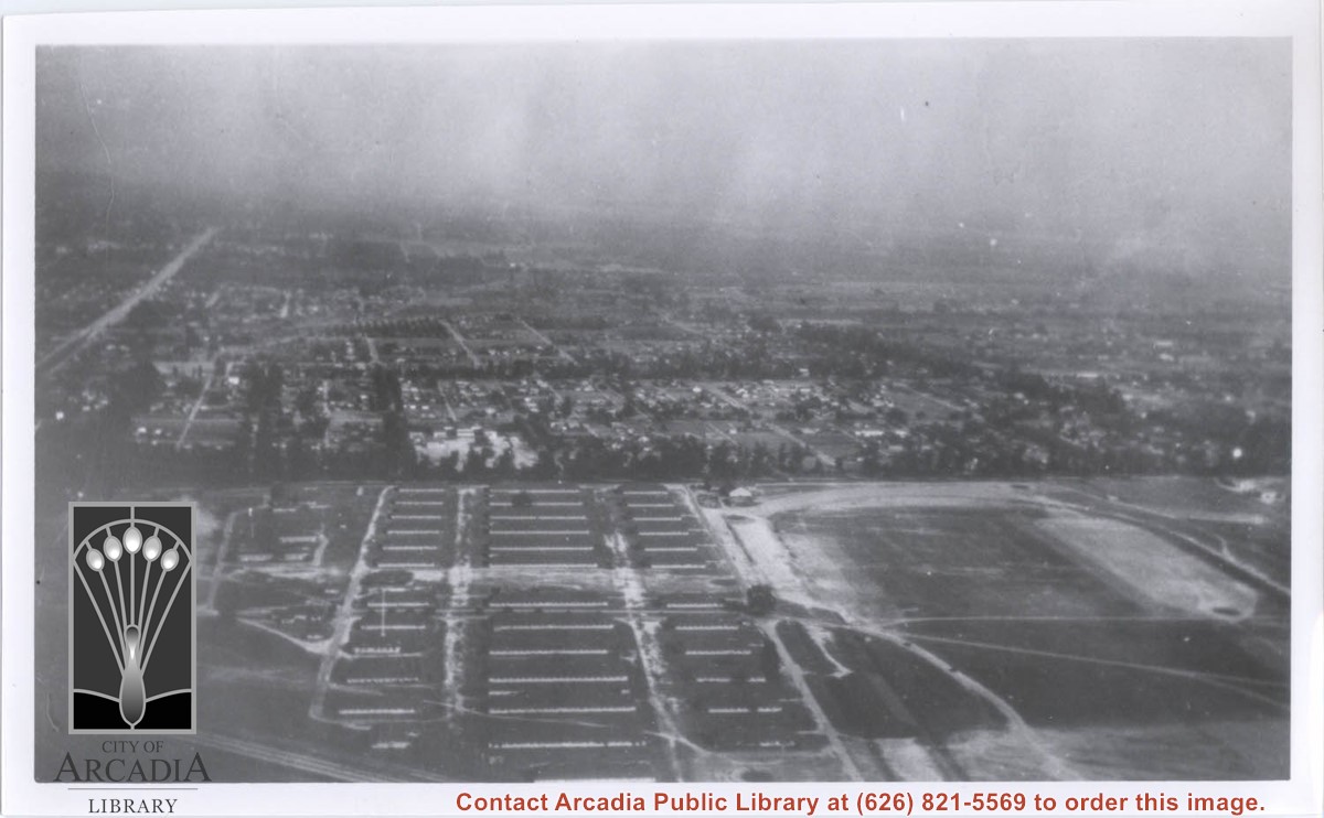
Looking east over barracks and main building at Ross Field. Tree-lined street cutting across photo at far side of field is Santa Anita Avenue. The oval of the race track built by E.J."Lucky" Baldwin and which opened in 1907 can clearly be seen on right. Broad E/W street seen on far left is Huntington Drive.
https://arcadiahistory.andornot.com/en/permalink/photographs867
- Date
- c.1928
1 image
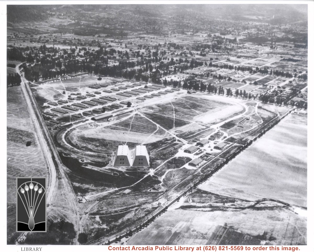
Aerial view of Ross Field looking east from a position of about Huntington Drive and present Holly Avenue. Two large hangars are at west point of triangular property. The wash cutting across foreground is the wash just to west of present high school.
https://arcadiahistory.andornot.com/en/permalink/photographs228
- Date
- c.1928
1 image
- Date
- c.1928
- Subjects
- Balloon School
- Arcadia County Park
- Physical Description
- 8x10 b&w
- ID
- 226
- Collection
- Photographs
Images
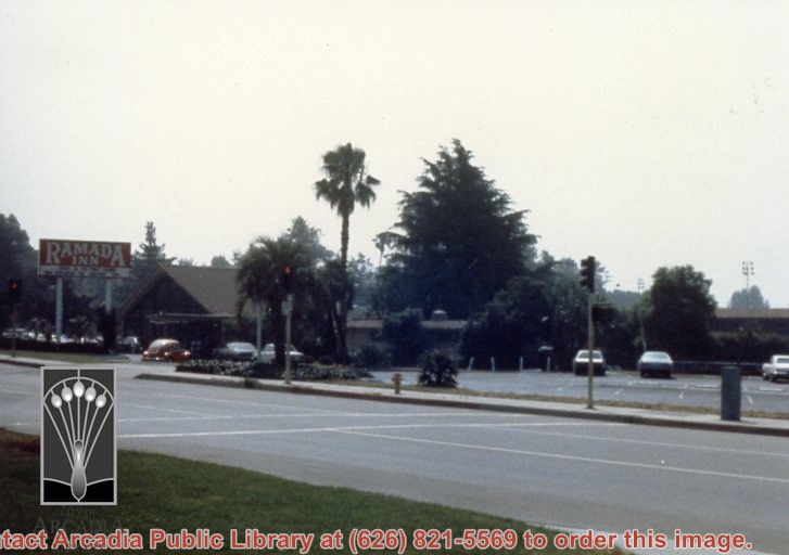
Ramada Inn at 130 W. Huntington Drive. Photo taken from across Huntington Drive. Includes the sign and parking lot. Former location of Lyon's Pony Express Museum.
https://arcadiahistory.andornot.com/en/permalink/photographs1229
- Date
- 1979
1 image
- Date
- 1979
- Subjects
- Ramada Inn
- Pony Express Museum
- Physical Description
- 4x5 color
- ID
- 1220
- Collection
- Photographs
Images
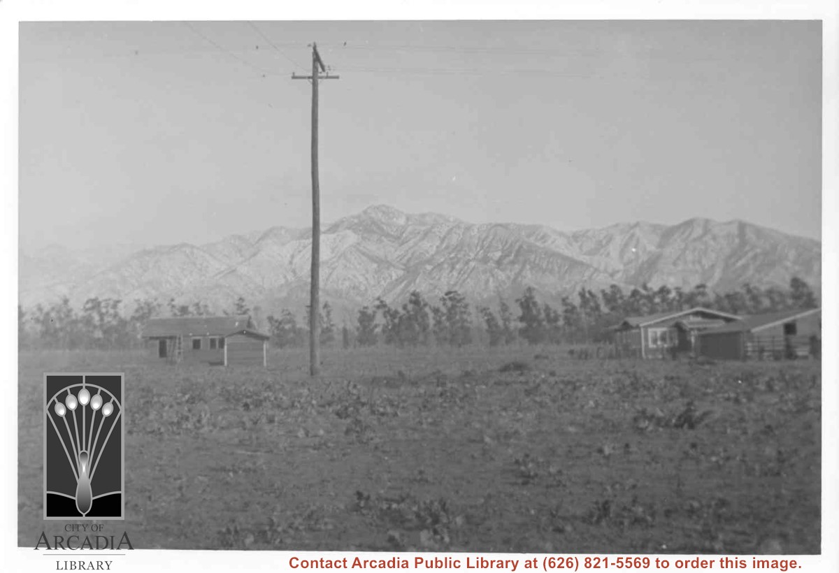
View from back yard of Ramuz family home on Arcadia Ave. looking north toward San Gabriel Mountains. (Later they would build home on South Santa Anita in conjunction with their business, The Arcadia Nursery.) There are two small houses, one on left is still under construction. Just to left of center is a power pole. Line of eucalyptus in background apparently was along Huntington Drive.
https://arcadiahistory.andornot.com/en/permalink/photographs884
- Date
- c.1917
1 image
- Date
- c.1917
- Subjects
- Houses
- San Gabriel Mountains
- Physical Description
- 7x10 b&w
- ID
- 878
- Collection
- Photographs
Images
Aerial view toward the east taken from about over present Club House at Santa Anita Park Race Track. The main street running North/South is Santa Anita Avenue. View shows the oval of Elias J. "Lucky" Baldwin's race track in what is currently Arcadia County Park. The buildings would be barracks of Ross Field U.S. Army Balloon School. Duarte Road can be seen coming into photo at right edge of photo near intersection with Santa Anita Avenue. The broad street along left side would be Huntington Drive. Railroad tracks can be seen in lower left corner.
https://arcadiahistory.andornot.com/en/permalink/photographs635
- Date
- November 1929
1 image
- Date
- November 1929
- Subjects
- Aerial Photo Collection
- Aerial views
- Balloon School
- Huntington Drive
- Race tracks
- Railroads
- Santa Anita Avenue
- Physical Description
- 6x10 b&w
- ID
- 631
- Collection
- Photographs
Images

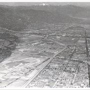
Aerial view toward NE. Main thoroughfare cutting across east to west with young trees planted on north side, is Huntington Drive. Main race track at Santa Anita is seen almost directly in center of photo, with Club House on side closest to camera. The smaller oval near left edge of photo was a training track belonging to Santa Anita which was removed for the Fashion Park. The Chantry Flats Road up to Santa Anita Canyon is clearly seen as it zig-zags around San Gabriel Mountains. This photo belongs to the Huntington Library. It is shown here for research only.
https://arcadiahistory.andornot.com/en/permalink/photographs629
- Date
- c. 1940s
1 image
- Date
- c. 1940s
- Subjects
- San Gabriel Mountains
- Santa Anita Park-1934-1942
- Chantry Flats Road
- Huntington Drive
- Fashion Park
- Physical Description
- 8x10 b&w
- ID
- 625
- Collection
- Photographs
Images