Westfield America Inc. has closed a deal with TrizecHahn Corp. to buy a 40 percent interest in Santa Anita Fashion Park.
https://arcadiahistory.andornot.com/en/permalink/newspaper15321
- Newspaper
- Pasadena Star News
- Date
- September 29, 1998
- Pages
- p. A1
- Subjects
- Santa Anita Fashion Park
- Item ID
- 15880AN
- Collection
- Newspaper Index
Westfield America Inc. announced yesterday that it will buy an additional 50 percent interest in Westfield Shoppingtown Santa Anita Fashion Park from Meditrust, giving it nearly 90 percent ownership.
https://arcadiahistory.andornot.com/en/permalink/newspaper16194
- Newspaper
- Pasadena Star News
- Date
- December 29, 1998
- Pages
- p. B5
- Subjects
- Santa Anita Park
- Item ID
- 16940AN
- Collection
- Newspaper Index
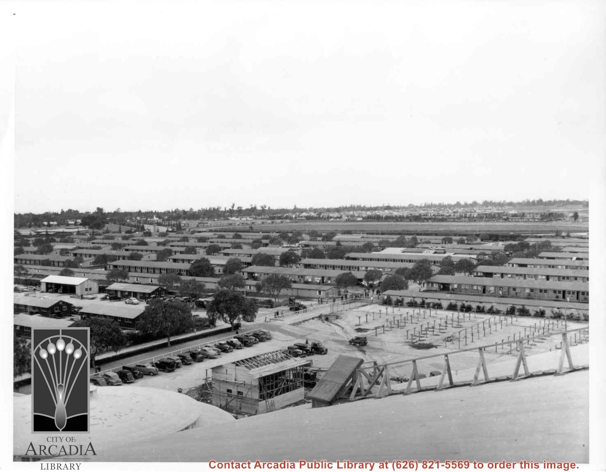
View almost due west from Santa Anita Race track Clubhouse roof over portion of housing put up for the evacuees at the Santa Anita Assembly Center for the Japanese. Note training track in the center of photo. Beyond it can be seen houses in Santa Anita Village. This entire area became part of Fashion Park later. This photo, together with photos #655 and 656, form a panorama.
https://arcadiahistory.andornot.com/en/permalink/photographs658
- Date
- April 1942
1 image
- Date
- April 1942
- Subjects
- Santa Anita Assembly Center for the Japanese-Buildings and grounds
- Santa Anita Park-1942-1945
- Fashion Park
- Physical Description
- 8x10 b&w
- ID
- 654
- Collection
- Photographs
Images
Gruen Associates, Inc. Santa Anita Fashion Park
https://arcadiahistory.andornot.com/en/permalink/subject346
- Contents
- 1. Gruen Associates, Inc. Santa Anita Fashion Park. Bound plans and sketches.
- Contents
- 1. Gruen Associates, Inc. Santa Anita Fashion Park. Bound plans and sketches.
- Location
- History Room
- Box Number
- Box 38
- Shelf Number
- Shelf B7
- Item ID
- 347AF
- Collection
- Subject Files
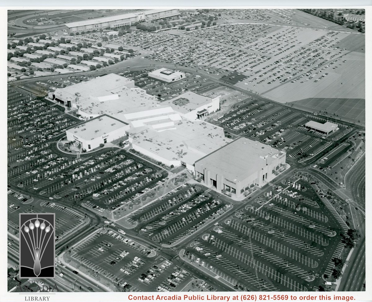
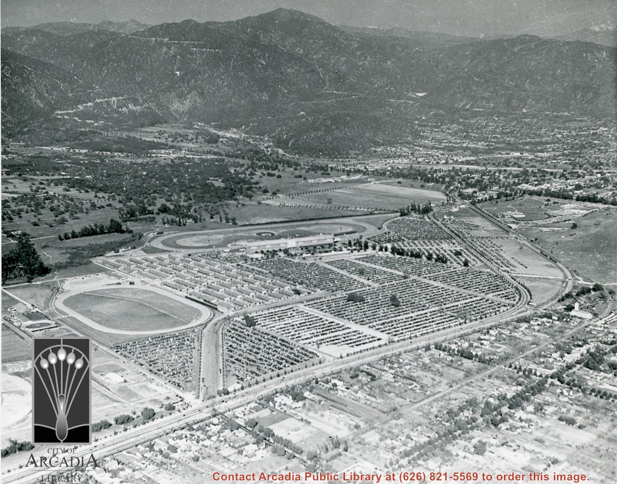
Aerial view looking towards San Gabriel Mountains showing intersection of Baldwin Avenue and Huntington Drive, the Santa Anita Park and training track where Santa Anita Fashion Park (currently known as Westfield Santa Anita Shopping Mall) was built.
https://arcadiahistory.andornot.com/en/permalink/photographs1754
- Date
- Unknown
1 image
- Date
- Unknown
- Subjects
- Aerial Photo Collection
- Aerial views
- Baldwin Avenue
- Huntington Drive
- Malls
- San Gabriel Mountains
- Santa Anita Fashion Park
- Santa Anita Park, 1945-1980
- Westfield Santa Anita Shopping Mall
- Physical Description
- 8x10 b&w photocopy
- ID
- 1742
- Collection
- Photographs
Images
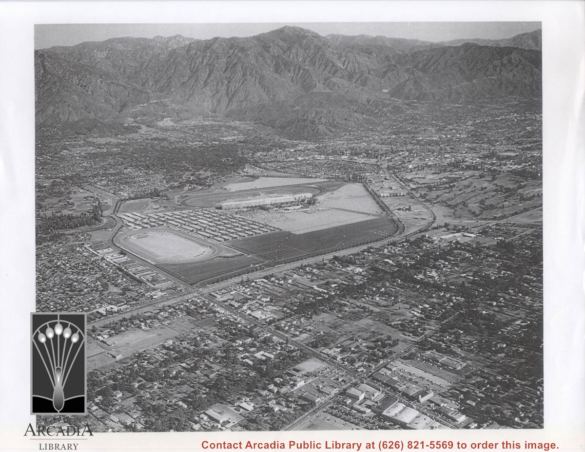
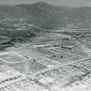
Aerial view toward north from a position south of Huntington Drive near intersection with Baldwin Avenue. It shows Santa Anita Fashion Park (currently known as Westfield Santa Anita Shopping Mall) developed by and on property owned by Santa Anita Consolidated. The Santa Anita Park Race Track and club house can be seen in center of photo. The straight white line about one inch above the club house roof is 210 Foothill Freeway. Chantry Flats road can be seen going up into San Gabriel Mountains in distance.
https://arcadiahistory.andornot.com/en/permalink/photographs646
- Date
- c. 1975
1 image
- Date
- c. 1975
- Subjects
- Aerial Photo Collection
- Aerial views
- 210 Foothill Freeway
- Chantry Flats Road
- Malls
- San Gabriel Mountains
- Santa Anita Park-1945-1980
- Santa Anita Fashion Park
- Westfield Santa Anita Shopping Mall
- Physical Description
- 8x10 b&w
- ID
- 642
- Collection
- Photographs
Images


The Santa Anita Fashion Park has a gender-neutral family bathroom which opened in early October.
https://arcadiahistory.andornot.com/en/permalink/newspaper11650
- Date
- December 19, 1997
- Pages
- p. 7
- Subjects
- Santa Anita Fashion Park
- Item ID
- 11861AN
- Collection
- Newspaper Index
Concerns about a proposed entertainment complex next to Santa Anita Park race track have been expressed by representatives of three stores in the Santa Anita Fashion Park.
https://arcadiahistory.andornot.com/en/permalink/newspaper6258
- Newspaper
- Pasadena Star News
- Date
- July 10, 1996
- Pages
- p. A1
- Item ID
- 6083AN
- Collection
- Newspaper Index
Aerial view toward SW from position just north of Santa Anita Race Track with large crowd in attendance. View shows planting design on the infield, the clubhouse, and to the west, the former training track belonging to Santa Anita. This and stables were removed or relocated to make room for the Fashion Park. Baldwin Avenue was not cut through at this time. This photo belongs to the Huntington Library. It is shown here for research only.
https://arcadiahistory.andornot.com/en/permalink/photographs630
- Date
- c. 1935
1 image

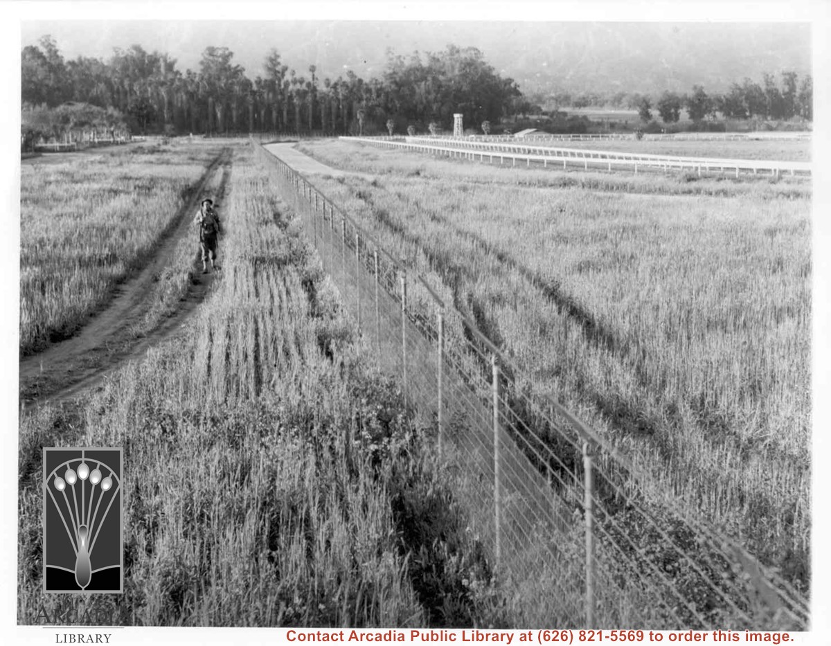
Lone army sentry patrolling outside fence of Santa Anita Assembly Center for the Japanese. White fencing encloses training track which was located alongside Baldwin Avenue, approximately where west parking area for Fashion Park (now Westfield Santa Anita mall) is now. Palm trees seen on left side, would be on grounds of present Arboretum.
https://arcadiahistory.andornot.com/en/permalink/photographs661
- Date
- April 1942
1 image
Multibillion dollar businessman and horse owner, Frank Stronach, has signed a letter of intent for his auto systems company, Magna International Inc., to buy Santa Anita Park
https://arcadiahistory.andornot.com/en/permalink/newspaper16086
- Newspaper
- Pasadena Star News
- Date
- November 15, 1998
- Pages
- p. C1 photos
- Pasadena Star News
- Newspaper
- Pasadena Star News
- Date
- November 15, 1998
- Pages
- p. C1 photos
- Pasadena Star News
- Subjects
- Santa Anita Park
- Item ID
- 16844AN
- Collection
- Newspaper Index
Andy Tran of Alhambra was stabbed by Enrique Farias at the Santa Anita Fashion Park and died as a result of the attack.
https://arcadiahistory.andornot.com/en/permalink/newspaper25925
- Newspaper
- Arcadia Weekly
- Date
- December 18, 1997
- Pages
- p. 1
- Subjects
- Tran, Andy
- Santa Anita Fashion Park
- Murder
- Stabbing
- Item ID
- 26125AN
- Collection
- Newspaper Index
International businessman and horse owner Frank Stronach confirmed Tuesday that he and Meditrust, the parent company of Santa Anita Park, have signed a letter of intent under which he will buy the race track.
https://arcadiahistory.andornot.com/en/permalink/newspaper16087
- Newspaper
- Pasadena Star News
- Date
- November 11, 1998
- Pages
- p. A1
- Subjects
- Santa Anita Park
- Item ID
- 16845AN
- Collection
- Newspaper Index
The owners of Westfield Shoppingtown Santa Anita (formerly Santa Anita Fashion Park), have submitted a request to the city to expand the building by as much as 55 %.
https://arcadiahistory.andornot.com/en/permalink/newspaper17052
- Newspaper
- Pasadena Star News
- Date
- June 28, 1999
- Pages
- p. A1
- Subjects
- Westfield Santa Anita
- Item ID
- 14482AN
- Collection
- Newspaper Index
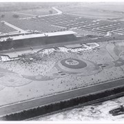
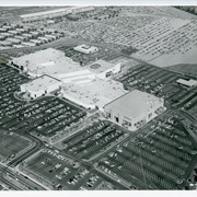
Aerial view looking down on Fashion Park from a position over intersection of Baldwin & Huntington Drive. Looking N toward Santa Anita Race Track grandstand during racing season (all of the cars parked on light-surfaced parking area are attending races.)
https://arcadiahistory.andornot.com/en/permalink/photographs736
- Date
- c.1975
1 image
Investors and horseracing interests are lining up to buy Santa Anita Park only one year after it was purchased by Meditrust.
https://arcadiahistory.andornot.com/en/permalink/newspaper15847
- Newspaper
- Pasadena Star News
- Date
- October 28, 1998
- Pages
- p. A1
- Subjects
- Santa Anita Park
- Item ID
- 16604AN
- Collection
- Newspaper Index
As the first stage of what the owners hope will be a 2-part improvement of Arcadia's Santa Anita Fashion Park, the 12-year-old shopping center has announced it will soon begin a $10.5 million interior and exterior remodeling.
https://arcadiahistory.andornot.com/en/permalink/newspaper1553
- Newspaper
- Arcadia Tribune
- Date
- August 30, 1987
- Pages
- p. A-1 photo
- Subjects
- Fashion Park
- Item ID
- 1552AN
- Collection
- Newspaper Index
Santa Anita Park Race Track just right of center at south edge of photo. Oval to the left of Santa Anita Park Race Track was training track which was removed to make room for Santa Anita Fashion Park (currently Westfield Santa Anita Shopping Mall). Street just to left of training track is Baldwin Avenue. Huntington Drive and Colorado Place form a "y" just east of Santa Anita Park Race Track. Along both can be noticed the conifer trees planted a few years earlier. Street completely bisecting photo just below center is Foothill Boulevard, next one is Orange Grove Avenue. Santa Anita Avenue is partially in view on right edge of photo. Oval on extreme lower left side of photo is old Baldwin training track. Baseball diamond in lower right corner is at Arcadia County Park. Scale: 1"=660'
https://arcadiahistory.andornot.com/en/permalink/photographs620
- Date
- June 5, 1938
1 image
- Date
- June 5, 1938
- Subjects
- Aerial Photo Collection
- Aerial views
- Baldwin Avenue
- Colorado Boulevard
- Colorado Place
- Colorado Street
- Foothill Boulevard
- Huntington Drive
- Orange Grove Avenue
- Santa Anita Fashion Park (later known as Westfield Santa Anita)
- Santa Anita Park-1934-1942
- Physical Description
- 8x10 b&w
- ID
- 616
- Collection
- Photographs
Images


Aerial view toward NE. Main thoroughfare cutting across east to west with young trees planted on north side, is Huntington Drive. Main race track at Santa Anita is seen almost directly in center of photo, with Club House on side closest to camera. The smaller oval near left edge of photo was a training track belonging to Santa Anita which was removed for the Fashion Park. The Chantry Flats Road up to Santa Anita Canyon is clearly seen as it zig-zags around San Gabriel Mountains. This photo belongs to the Huntington Library. It is shown here for research only.
https://arcadiahistory.andornot.com/en/permalink/photographs629
- Date
- c. 1940s
1 image
- Date
- c. 1940s
- Subjects
- San Gabriel Mountains
- Santa Anita Park-1934-1942
- Chantry Flats Road
- Huntington Drive
- Fashion Park
- Physical Description
- 8x10 b&w
- ID
- 625
- Collection
- Photographs
Images
Months of talks between Westfield Shopping Town Santa Anita and Santa Anita Park race track about building a shopping center seem to have fallen through.
https://arcadiahistory.andornot.com/en/permalink/newspaper18184
- Newspaper
- Pasadena Star News
- Date
- January 12, 2000
- Pages
- p. A3
- Subjects
- Westfield Santa Anita
- Santa Anita Park
- Item ID
- 18431AN
- Collection
- Newspaper Index